![](/images/other/stat-length.png)
![Tocht Stappen Fanlo - Canyon d’Anisclo et village 10 km - Photo](https://media.geolcdn.com/t/1900/400/9073b980-85fc-4706-93e6-44f34959e40c.jpg&format=pjpeg&maxdim=2)
Canyon d’Anisclo et village 10 km
rvapeldo
Gebruiker GUIDE
![Lengte](/images/other/stat-length.png)
![Max. hoogte](https://static1.geolcdn.com/siteimages/upload/files/1508320355ic_sort_altitude_max_24dp.png)
![Positief hoogteverschil](https://static1.geolcdn.com/siteimages/upload/files/1508320355ic_sort_den_pos_24dp.png)
![Km-Effort](/images/other/stat-length.png)
![Min. hoogte](https://static1.geolcdn.com/siteimages/upload/files/1508320355ic_sort_altitude_min_24dp.png)
![Negatief hoogteverschil](https://static1.geolcdn.com/siteimages/upload/files/1508320355ic_sort_den_neg_24dp.png)
![Boucle](https://static1.geolcdn.com/siteimages/upload/files/16400158638029165_repeat_loop_refresh_sync_direction_icon.png)
![Stappen](https://static1.geolcdn.com/sitytour/trail-icons/101.png)
5h02
Moeilijkheid : Medium
![Scan deze QR-code om de tocht te openen in de SityTrail-applicatie](https://capi.geolives.com/qq0zvz2zws4bq2lad0pu/sitytour/trails/2145662/qr.png?size=200)
Gratisgps-wandelapplicatie
Over ons
Tocht Stappen van 11 km beschikbaar op Aragón, Huesca, Fanlo. Deze tocht wordt voorgesteld door rvapeldo.
Beschrijving
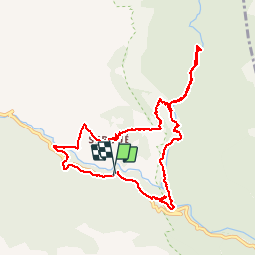
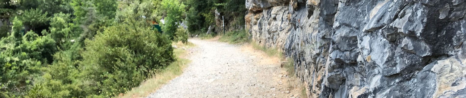
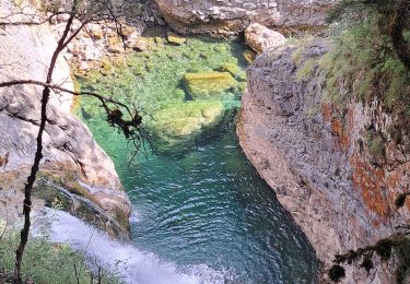
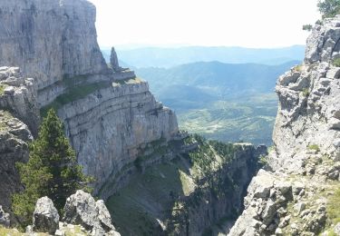
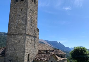
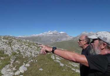
La randonnée associe une boucle qui passe par le village de Sercué, en reconstruction (voir photo de l’église branlante) et une exploration du magnifique canyon d’Anisclo et ses vasques successives, un cousin du Verdon (qui peut être plus longue que celle réalisée ici). C’est une randonnée d’intensité moyenne, qui part d’un parking le long de la route (de la Tella), mais il y a moyen de se garer au parking de San Urbez un peu plus bas, situé au déboucher de la vallée d’Anisclo. Une variante de la boucle consiste à descendre, au même endroit, en direction du moulin, pour approcher le cours d’eau et remonter vers l’ouest. Une partie de la boucle est constituée par un le GR15. Pas de difficulté majeure, mais il faut ouvrir l’oeil dans la descente du village de Sercué au bas du canyon d’Anisclo (qui je crois est un bout du GR15).
Plaatsbepaling
Opmerkingen
Wandeltochten in de omgeving
![Tocht Stappen Fanlo - Pyrénées 2023 Jour 9 - Canyon d'Anisclo - Photo](https://media.geolcdn.com/t/375/260/6b784207-fdda-452c-9ac5-99b78cc61698.jpg&format=jpg&maxdim=2)
![Stappen Stappen](https://static1.geolcdn.com/sitytour/trail-icons/101.png)
Stappen
![](/images/other/stat-length.png)
![](https://static1.geolcdn.com/siteimages/upload/files/16400158638029165_repeat_loop_refresh_sync_direction_icon.png)
![Tocht Stappen Puértolas - Les Sestrales depuis le col de Plana Canal - Photo](https://media.geolcdn.com/t/375/260/aa043a3b-808c-4320-b2bd-83fe386b8b3c.jpg&format=jpg&maxdim=2)
![Stappen Stappen](https://static1.geolcdn.com/sitytour/trail-icons/101.png)
Stappen
![](/images/other/stat-length.png)
![](https://static1.geolcdn.com/siteimages/upload/files/16400158638029165_repeat_loop_refresh_sync_direction_icon.png)
![Tocht Paardrijden Fanlo - Parc National d’Ordesa J4 - Photo](https://media.geolcdn.com/t/375/260/81b3b568-951e-4f6b-a2a4-194ea0c30949.jpg&format=jpg&maxdim=2)
![Paardrijden Paardrijden](https://static1.geolcdn.com/sitytour/trail-icons/301.png)
Paardrijden
![](/images/other/stat-length.png)
![](https://static1.geolcdn.com/siteimages/upload/files/16400158638029165_repeat_loop_refresh_sync_direction_icon.png)
![Tocht Stappen Puértolas - SESTRALES BAJO - Photo](https://media.geolcdn.com/t/375/260/5f36201a-6efe-4392-809e-cc57fb1ae425.jpg&format=jpg&maxdim=2)
![Stappen Stappen](https://static1.geolcdn.com/sitytour/trail-icons/101.png)
Stappen
![](/images/other/stat-length.png)
![](https://static1.geolcdn.com/siteimages/upload/files/16400158638029165_repeat_loop_refresh_sync_direction_icon.png)
![Tocht Te voet Fanlo - Nerin - canyon d'Anisclo - Photo](https://media.geolcdn.com/t/375/260/ext.jpg?maxdim=2&url=https%3A%2F%2Fstatic1.geolcdn.com%2Fsiteimages%2Fupload%2Ffiles%2F1545311037marcheuse_200dpi.jpg)
![Te voet Te voet](https://static1.geolcdn.com/sitytour/trail-icons/100.png)
Te voet
![](/images/other/stat-length.png)
![](https://static1.geolcdn.com/siteimages/upload/files/16400158638029165_repeat_loop_refresh_sync_direction_icon.png)
![Tocht Stappen Fanlo - Canyon d'Anisclo - Photo](https://media.geolcdn.com/t/375/260/ext.jpg?maxdim=2&url=https%3A%2F%2Fstatic1.geolcdn.com%2Fsiteimages%2Fupload%2Ffiles%2F1553511878bg_sport_marche.png)
![Stappen Stappen](https://static1.geolcdn.com/sitytour/trail-icons/101.png)
Stappen
![](/images/other/stat-length.png)
![](https://static1.geolcdn.com/siteimages/upload/files/16400158638029165_repeat_loop_refresh_sync_direction_icon.png)
![Tocht Stappen Fanlo - petit sestrale - Photo](https://media.geolcdn.com/t/375/260/ext.jpg?maxdim=2&url=https%3A%2F%2Fstatic1.geolcdn.com%2Fsiteimages%2Fupload%2Ffiles%2F1553511878bg_sport_marche.png)
![Stappen Stappen](https://static1.geolcdn.com/sitytour/trail-icons/101.png)
Stappen
![](/images/other/stat-length.png)
![](https://static1.geolcdn.com/siteimages/upload/files/16400158638029165_repeat_loop_refresh_sync_direction_icon.png)
![Tocht Stappen Fanlo - 31_7_24 - Photo](https://media.geolcdn.com/t/375/260/ext.jpg?maxdim=2&url=https%3A%2F%2Fstatic1.geolcdn.com%2Fsiteimages%2Fupload%2Ffiles%2F1553511878bg_sport_marche.png)
![Stappen Stappen](https://static1.geolcdn.com/sitytour/trail-icons/101.png)
![Tocht Stappen Fanlo - Buerba circular - Photo](https://media.geolcdn.com/t/375/260/ext.jpg?maxdim=2&url=https%3A%2F%2Fstatic1.geolcdn.com%2Fsiteimages%2Fupload%2Ffiles%2F1553511878bg_sport_marche.png)
![Stappen Stappen](https://static1.geolcdn.com/sitytour/trail-icons/101.png)