![](/images/other/stat-length.png)
![Tocht Stappen Le Bourg-d'Oisans - Villard Notre Dame - Col du Solude par le sentier de la gorge - Photo](https://media.geolcdn.com/t/1900/400/6e0a8b97-e4d6-4688-9a9b-475ac3d800eb.jpg&format=pjpeg&maxdim=2)
Villard Notre Dame - Col du Solude par le sentier de la gorge
patjobou
Gebruiker
![Lengte](/images/other/stat-length.png)
![Max. hoogte](https://static1.geolcdn.com/siteimages/upload/files/1508320355ic_sort_altitude_max_24dp.png)
![Positief hoogteverschil](https://static1.geolcdn.com/siteimages/upload/files/1508320355ic_sort_den_pos_24dp.png)
![Km-Effort](/images/other/stat-length.png)
![Min. hoogte](https://static1.geolcdn.com/siteimages/upload/files/1508320355ic_sort_altitude_min_24dp.png)
![Negatief hoogteverschil](https://static1.geolcdn.com/siteimages/upload/files/1508320355ic_sort_den_neg_24dp.png)
![Boucle](https://static1.geolcdn.com/siteimages/upload/files/16400158638029165_repeat_loop_refresh_sync_direction_icon.png)
![Stappen](https://static1.geolcdn.com/sitytour/trail-icons/101.png)
5h57
Moeilijkheid : Moeilijk
![Scan deze QR-code om de tocht te openen in de SityTrail-applicatie](https://capi.geolives.com/qq0zvz2zws4bq2lad0pu/sitytour/trails/2137426/qr.png?size=200)
Gratisgps-wandelapplicatie
Over ons
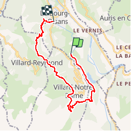
Tocht Stappen van 15,9 km beschikbaar op Auvergne-Rhône-Alpes, Isère, Le Bourg-d'Oisans. Deze tocht wordt voorgesteld door patjobou.
Beschrijving
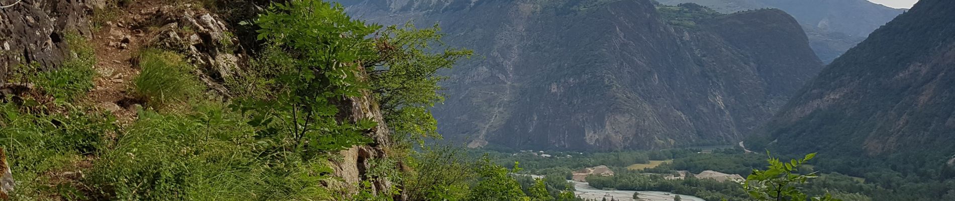
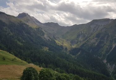
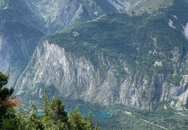
Belle boucle sur les Hauteurs de Bourg d'Oisans, face au confluent de La Romanche et du Vénéon.
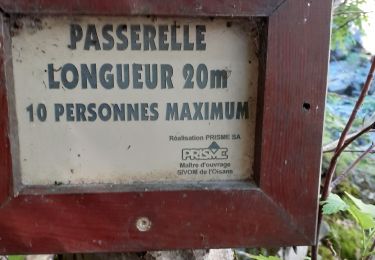
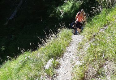
Les premiers 800m de montée sont très soutenus, avec des passages aménagés (marches, câbles, pont népalais). La suite est classique. La descente se fait sur un bon sentier bien tracé. Belles vues sur l'Oisans. Il est judicieux de faire une 'manip de voiture', entre Le Bourg d'Oisans et Le Pont du Fournol, pour gagner 3 km de marche à plat sur route.
Il est possible de rallonger un peu, en passant par 'Les Maisons du Loup', ce qui rajoute 120m de dénivelé.
Plaatsbepaling
Opmerkingen
Wandeltochten in de omgeving
![Tocht Stappen Le Bourg-d'Oisans - 38 BG d Oisans cascade pisse - Photo](https://media.geolcdn.com/t/375/260/2e81579a-11c0-4302-b399-8bc55cc0dd5f.jpg&format=jpg&maxdim=2)
![Stappen Stappen](https://static1.geolcdn.com/sitytour/trail-icons/101.png)
Stappen
![](/images/other/stat-length.png)
![](https://static1.geolcdn.com/siteimages/upload/files/16400158638029165_repeat_loop_refresh_sync_direction_icon.png)
![Tocht Ski randonnée Oulles - Le Grand Galbert - Photo](https://media.geolcdn.com/t/375/260/deb5abfe-9d12-4610-a034-8cf37e109247.jpg&format=jpg&maxdim=2)
![Ski randonnée Ski randonnée](https://static1.geolcdn.com/sitytour/trail-icons/503.png)
Ski randonnée
![](/images/other/stat-length.png)
![](https://static1.geolcdn.com/siteimages/upload/files/16400158638029165_repeat_loop_refresh_sync_direction_icon.png)
![Tocht Stappen Le Bourg-d'Oisans - Lac de Buclet et cascade de la Pisse - Photo](https://media.geolcdn.com/t/375/260/7920e5ce-d45f-4ce3-8489-7c3261ef3795.jpg&format=jpg&maxdim=2)
![Stappen Stappen](https://static1.geolcdn.com/sitytour/trail-icons/101.png)
Stappen
![](/images/other/stat-length.png)
![](https://static1.geolcdn.com/siteimages/upload/files/16400158638029165_repeat_loop_refresh_sync_direction_icon.png)
![Tocht Ski randonnée Auris - 220123 les Buffes - Photo](https://media.geolcdn.com/t/375/260/1f219626-40f4-4df5-bc13-28244765ba6f.jpg&format=jpg&maxdim=2)
![Ski randonnée Ski randonnée](https://static1.geolcdn.com/sitytour/trail-icons/503.png)
Ski randonnée
![](/images/other/stat-length.png)
![](https://static1.geolcdn.com/siteimages/upload/files/16400158638029165_repeat_loop_refresh_sync_direction_icon.png)
![Tocht Stappen Villard-Reymond - La Croix du Carrelet et la crête de Croix de La Garde - Photo](https://media.geolcdn.com/t/375/260/719f71c8-5764-4d7d-9547-f0e72ea0e1f5.jpg&format=jpg&maxdim=2)
![Stappen Stappen](https://static1.geolcdn.com/sitytour/trail-icons/101.png)
Stappen
![](/images/other/stat-length.png)
![](https://static1.geolcdn.com/siteimages/upload/files/16400158638029165_repeat_loop_refresh_sync_direction_icon.png)
![Tocht Stappen Auris - Auris en Oizan- balade vers Placet - Photo](https://media.geolcdn.com/t/375/260/5a0f490f-c9f2-4b39-aad1-de8711b6f381.jpg&format=jpg&maxdim=2)
![Stappen Stappen](https://static1.geolcdn.com/sitytour/trail-icons/101.png)
Stappen
![](/images/other/stat-length.png)
![](https://static1.geolcdn.com/siteimages/upload/files/16400158638029165_repeat_loop_refresh_sync_direction_icon.png)
![Tocht Stappen Le Bourg-d'Oisans - Bourg d'Oisans les cascades - Photo](https://media.geolcdn.com/t/375/260/f162be93-5b19-484b-970f-69f2c59af7f2.jpg&format=jpg&maxdim=2)
![Stappen Stappen](https://static1.geolcdn.com/sitytour/trail-icons/101.png)
Stappen
![](/images/other/stat-length.png)
![](https://static1.geolcdn.com/siteimages/upload/files/16400158638029165_repeat_loop_refresh_sync_direction_icon.png)
![Tocht Stappen Villard-Notre-Dame - villard Redmond - Photo](https://media.geolcdn.com/t/375/260/06639bd3-b0d9-4d0a-b2aa-40bb1a3232fe.jpg&format=jpg&maxdim=2)
![Stappen Stappen](https://static1.geolcdn.com/sitytour/trail-icons/101.png)
Stappen
![](/images/other/stat-length.png)
![](https://static1.geolcdn.com/siteimages/upload/files/16400158638029165_repeat_loop_refresh_sync_direction_icon.png)
![Tocht Sneeuwschoenen Auris - Alpe d'Huez - Gorges de La Sarenne - Photo](https://media.geolcdn.com/t/375/260/ext.jpg?maxdim=2&url=https%3A%2F%2Fservices.sitytrail.com%2FGeolivesWS%2FDownloadMedia.ashx%3FTrailID%3D1105322%26Media%3Dfix__20190131122334.jpg)
![Sneeuwschoenen Sneeuwschoenen](https://static1.geolcdn.com/sitytour/trail-icons/504.png)
Sneeuwschoenen
![](/images/other/stat-length.png)
![](https://static1.geolcdn.com/siteimages/upload/files/16400158638029165_repeat_loop_refresh_sync_direction_icon.png)