![](/images/other/stat-length.png)
![Tocht Stappen Maasmechelen - Maasmechelen - Photo](https://media.geolcdn.com/t/1900/400/ext.pjpeg?maxdim=2&url=https%3A%2F%2Fstatic1.geolcdn.com%2Fsiteimages%2Fupload%2Ffiles%2F1553511878bg_sport_marche.png)
Maasmechelen
flip96
Gebruiker
![Lengte](/images/other/stat-length.png)
Lengte
17,2 km
![Max. hoogte](https://static1.geolcdn.com/siteimages/upload/files/1508320355ic_sort_altitude_max_24dp.png)
Max. hoogte
101 m
![Positief hoogteverschil](https://static1.geolcdn.com/siteimages/upload/files/1508320355ic_sort_den_pos_24dp.png)
Positief hoogteverschil
173 m
![Km-Effort](/images/other/stat-length.png)
Km-Effort
19,5 km
![Min. hoogte](https://static1.geolcdn.com/siteimages/upload/files/1508320355ic_sort_altitude_min_24dp.png)
Min. hoogte
48 m
![Negatief hoogteverschil](https://static1.geolcdn.com/siteimages/upload/files/1508320355ic_sort_den_neg_24dp.png)
Negatief hoogteverschil
173 m
![Boucle](https://static1.geolcdn.com/siteimages/upload/files/16400158638029165_repeat_loop_refresh_sync_direction_icon.png)
Boucle
Ja
Datum van aanmaak :
2014-12-10 00:00:00.0
Laatste wijziging :
2014-12-10 00:00:00.0
![Stappen](https://static1.geolcdn.com/sitytour/trail-icons/101.png)
4h20
Moeilijkheid : Gemakkelijk
![Scan deze QR-code om de tocht te openen in de SityTrail-applicatie](https://capi.geolives.com/qq0zvz2zws4bq2lad0pu/sitytour/trails/213742/qr.png?size=200)
Gratisgps-wandelapplicatie
Over ons
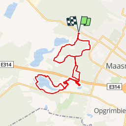
Tocht Stappen van 17,2 km beschikbaar op Vlaanderen, Limburg, Maasmechelen. Deze tocht wordt voorgesteld door flip96.
Beschrijving
Rondwandeling op de Mechelse Heide. Vanuit Maasmechelen, Poort Nationale Park K5 (Joseph Smeetslaan 280 Maasmechelen).
Mooie, eenvoudige wandeling met in augustus/september bloeiende heide.
Prachtige waterplassen in voormalige zandgroeve.
Opmerkingen? flip96@home.nl
Plaatsbepaling
Land:
Belgium
Regio :
Vlaanderen
Departement/Provincie :
Limburg
Gemeente :
Maasmechelen
Locatie:
Mechelen-aan-de-Maas
Vertrek:(Dec)
Vertrek:(UTM)
686663 ; 5650755 (31U) N.
Opmerkingen
Wandeltochten in de omgeving
![Tocht Stappen Maasmechelen - Mechelse Heide - Photo](https://media.geolcdn.com/t/375/260/ext.jpg?maxdim=2&url=https%3A%2F%2Fmedia.geolcdn.com%2Ff%2F501f02e9-8086-4be8-98c9-f01120ddee06.jpg)
![Stappen Stappen](https://static1.geolcdn.com/sitytour/trail-icons/101.png)
Mechelse Heide
Stappen
Gemakkelijk
(2)
Maasmechelen,
Vlaanderen,
Limburg,
Belgium
![](/images/other/stat-length.png)
14,2 km | 16,2 km-effort
3h 41min
![](https://static1.geolcdn.com/siteimages/upload/files/16400158638029165_repeat_loop_refresh_sync_direction_icon.png)
Ja
![Tocht Te voet As - Mechelse Heide Noord - Photo](https://media.geolcdn.com/t/375/260/ext.jpg?maxdim=2&url=https%3A%2F%2Fmedia.geolcdn.com%2Ff%2F6c3d6be9-86c4-472e-82c2-64c07d2c49aa.jpeg)
![Te voet Te voet](https://static1.geolcdn.com/sitytour/trail-icons/100.png)
Mechelse Heide Noord
Te voet
Gemakkelijk
As,
Vlaanderen,
Limburg,
Belgium
![](/images/other/stat-length.png)
4,3 km | 4,8 km-effort
1h 5min
![](https://static1.geolcdn.com/siteimages/upload/files/16400158638029165_repeat_loop_refresh_sync_direction_icon.png)
Neen
![Tocht Te voet Maasmechelen - Erfgoedwandeling Eisden Tuinwijk - Photo](https://media.geolcdn.com/t/375/260/ext.jpg?maxdim=2&url=https%3A%2F%2Fmedia.geolcdn.com%2Ff%2F28db0122-7bbc-4a11-ae3a-faea898e04f5.jpeg)
![Te voet Te voet](https://static1.geolcdn.com/sitytour/trail-icons/100.png)
Erfgoedwandeling Eisden Tuinwijk
Te voet
Gemakkelijk
Maasmechelen,
Vlaanderen,
Limburg,
Belgium
![](/images/other/stat-length.png)
3,1 km | 3,3 km-effort
44min
![](https://static1.geolcdn.com/siteimages/upload/files/16400158638029165_repeat_loop_refresh_sync_direction_icon.png)
Ja
![Tocht Te voet Dilsen-Stokkem - Connecterra Rode driehoek - Photo](https://media.geolcdn.com/t/375/260/ext.jpg?maxdim=2&url=https%3A%2F%2Fmedia.geolcdn.com%2Ff%2F5eb5c103-eb27-4a59-83d3-dfd2672ebb0c.jpeg)
![Te voet Te voet](https://static1.geolcdn.com/sitytour/trail-icons/100.png)
Connecterra Rode driehoek
Te voet
Gemakkelijk
Dilsen-Stokkem,
Vlaanderen,
Limburg,
Belgium
![](/images/other/stat-length.png)
6,2 km | 7 km-effort
1h 35min
![](https://static1.geolcdn.com/siteimages/upload/files/16400158638029165_repeat_loop_refresh_sync_direction_icon.png)
Neen
![Tocht Te voet Maasmechelen - Station As Groene rechthoek - Photo](https://media.geolcdn.com/t/375/260/ext.jpg?maxdim=2&url=https%3A%2F%2Fmedia.geolcdn.com%2Ff%2F6c3d6be9-86c4-472e-82c2-64c07d2c49aa.jpeg)
![Te voet Te voet](https://static1.geolcdn.com/sitytour/trail-icons/100.png)
Station As Groene rechthoek
Te voet
Gemakkelijk
Maasmechelen,
Vlaanderen,
Limburg,
Belgium
![](/images/other/stat-length.png)
3,3 km | 3,8 km-effort
51min
![](https://static1.geolcdn.com/siteimages/upload/files/16400158638029165_repeat_loop_refresh_sync_direction_icon.png)
Ja
![Tocht Te voet Maasmechelen - Leut & Meeswijk Gele zeshoek - Photo](https://media.geolcdn.com/t/375/260/ext.jpg?maxdim=2&url=https%3A%2F%2Fmedia.geolcdn.com%2Ff%2F3a349166-7856-4cc9-a007-a2d01b733e80.jpeg)
![Te voet Te voet](https://static1.geolcdn.com/sitytour/trail-icons/100.png)
Leut & Meeswijk Gele zeshoek
Te voet
Gemakkelijk
Maasmechelen,
Vlaanderen,
Limburg,
Belgium
![](/images/other/stat-length.png)
7 km | 7,4 km-effort
1h 40min
![](https://static1.geolcdn.com/siteimages/upload/files/16400158638029165_repeat_loop_refresh_sync_direction_icon.png)
Ja
![Tocht Te voet Maasmechelen - Station As Blauwe ruit - Photo](https://media.geolcdn.com/t/375/260/ext.jpg?maxdim=2&url=https%3A%2F%2Fmedia.geolcdn.com%2Ff%2F6c3d6be9-86c4-472e-82c2-64c07d2c49aa.jpeg)
![Te voet Te voet](https://static1.geolcdn.com/sitytour/trail-icons/100.png)
Station As Blauwe ruit
Te voet
Gemakkelijk
Maasmechelen,
Vlaanderen,
Limburg,
Belgium
![](/images/other/stat-length.png)
6,5 km | 7,1 km-effort
1h 36min
![](https://static1.geolcdn.com/siteimages/upload/files/16400158638029165_repeat_loop_refresh_sync_direction_icon.png)
Ja
![Tocht Te voet Maasmechelen - Station As Rode driehoek - Photo](https://media.geolcdn.com/t/375/260/ext.jpg?maxdim=2&url=https%3A%2F%2Fmedia.geolcdn.com%2Ff%2F6649a029-f07f-4f45-b4d8-2b574463e7fd.jpeg)
![Te voet Te voet](https://static1.geolcdn.com/sitytour/trail-icons/100.png)
Station As Rode driehoek
Te voet
Gemakkelijk
Maasmechelen,
Vlaanderen,
Limburg,
Belgium
![](/images/other/stat-length.png)
12 km | 13,4 km-effort
3h 3min
![](https://static1.geolcdn.com/siteimages/upload/files/16400158638029165_repeat_loop_refresh_sync_direction_icon.png)
Ja
![Tocht Te voet Dilsen-Stokkem - Litzberg groene rechthoek - Photo](https://media.geolcdn.com/t/375/260/ext.jpg?maxdim=2&url=https%3A%2F%2Fmedia.geolcdn.com%2Ff%2F085d16b1-ffd1-4281-a4d3-38ce31d4ff24.jpeg)
![Te voet Te voet](https://static1.geolcdn.com/sitytour/trail-icons/100.png)
Litzberg groene rechthoek
Te voet
Gemakkelijk
Dilsen-Stokkem,
Vlaanderen,
Limburg,
Belgium
![](/images/other/stat-length.png)
3 km | 3,7 km-effort
49min
![](https://static1.geolcdn.com/siteimages/upload/files/16400158638029165_repeat_loop_refresh_sync_direction_icon.png)
Ja