Tocht Stappen Saint-Martin-de-Queyrières - 2 - Compostelle/Bouchier - Mont-Dauphin 020719 - Photo

2 - Compostelle/Bouchier - Mont-Dauphin 020719

 R@ph
R@ph

Gebruiker GUIDE

© OpenStreetMap contributors
Lengte
Lengte
33 km
Max. hoogte
Max. hoogte
1651 m
Positief hoogteverschil
1010 m
Km-Effort
Km-Effort  
48 km
Min. hoogte
Min. hoogte
901 m
Negatief hoogteverschil
1502 m
Boucle
Boucle
Neen
Datum van aanmaak :
2019-07-10 06:20:56.278
Laatste wijziging :
2019-07-10 14:53:06.628

(0 Bericht)

Stappen
Stappen
10h07
Moeilijkheid : Zeer moeilijk

Scan deze QR-code om de tocht te openen in de SityTrail-applicatie

Gratisgps-wandelapplicatie

Logo SityTrail SityTrail

IGN / Geografische instituten

SityTrail uit de App Store downloaden SityTrail uit Google Play downloaden

Logo SityTrail SityTrail World

De wereld gaat voor u open

SityTrail uit de App Store downloaden SityTrail uit Google Play downloaden SityTrail op Huawei AppGallery downloaden

Over ons

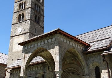
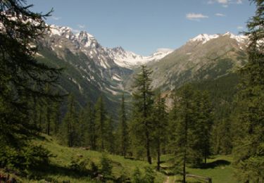
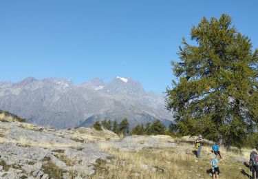
Tocht Stappen van 33 km beschikbaar op Provence-Alpes-Côte d'Azur, Hautes-Alpes, Saint-Martin-de-Queyrières. Deze tocht wordt voorgesteld door R@ph.

Hoogteprofiel

Plaatsbepaling

Land:
France
Regio :
Provence-Alpes-Côte d'Azur
Departement/Provincie :
Hautes-Alpes
Gemeente :
Saint-Martin-de-Queyrières
Locatie:
Unknown
Vertrek:(UTM)
307441 ; 4966969 (32T) N.

Wandeltochten in de omgeving

Tocht Trail Puy-Saint-André - Clos du Vas - Puy Chalvin - Photo
Trail
GUIDE
toutankhcarton

Trail

Medium
Puy-Saint-André, Provence-Alpes-Côte d'Azur, Hautes-Alpes, France
7,4 km | 13,4 km-effort
1h 30min
Ja
Tocht Lopen Puy-Saint-André - Clos du Vas - St Blaise - Briançon - Villar St Pancrace (Hautes-Alpes) - Photo
Lopen
GUIDE
toutankhcarton

Lopen

Medium
Puy-Saint-André, Provence-Alpes-Côte d'Azur, Hautes-Alpes, France
8 km | 10 km-effort
1h 7min
Ja
Tocht Te voet Vallouise-Pelvoux - Boucle de Vallouise - Photo
Te voet
GUIDE+

Te voet

Gemakkelijk
Vallouise-Pelvoux, Provence-Alpes-Côte d'Azur, Hautes-Alpes, France
8,1 km | 11,6 km-effort
2h 38min
Ja
Tocht Te voet Les Vigneaux - Tour des Vigneaux - Photo
Te voet
GUIDE+

Te voet

Gemakkelijk
Les Vigneaux, Provence-Alpes-Côte d'Azur, Hautes-Alpes, France
5,7 km | 7,5 km-effort
1h 42min
Ja
Tocht Stappen Saint-Martin-de-Queyrières - Tête du Puy (Argentière La Bessée) - Photo
Stappen
PapouBertrand

Stappen

Zeer moeilijk
Saint-Martin-de-Queyrières, Provence-Alpes-Côte d'Azur, Hautes-Alpes, France
11,3 km | 25 km-effort
6h 11min
Ja
Tocht Te voet Les Vigneaux - Entre Parapin et Gyronde - Photo
Te voet
GUIDE+

Te voet

Gemakkelijk
Les Vigneaux, Provence-Alpes-Côte d'Azur, Hautes-Alpes, France
5,8 km | 8,3 km-effort
1h 53min
Ja
Tocht Stappen Puy-Saint-Vincent - Les Têtes - Puy Saint Vincent - Photo
Stappen
tracegps

Stappen

Medium
Puy-Saint-Vincent, Provence-Alpes-Côte d'Azur, Hautes-Alpes, France
12,3 km | 21 km-effort
4h 0min
Ja
Tocht Stappen Les Vigneaux - têtes et lacs - Photo
Stappen
nde

Stappen

Gemakkelijk
(2)
Les Vigneaux, Provence-Alpes-Côte d'Azur, Hautes-Alpes, France
7,1 km | 11 km-effort
2h 40min
Ja
Tocht Stappen L'Argentière-la-Bessée - Les Têtes et tête d'Oréac  - Photo
Stappen
GUIDE
orsel

Stappen

Medium
L'Argentière-la-Bessée, Provence-Alpes-Côte d'Azur, Hautes-Alpes, France
14,8 km | 29 km-effort
6h 23min
Ja


Sluiten
Mijn abonnementen