![](/images/other/stat-length.png)
![Tocht Stappen Vallorbe - dent de Vaulion et mont d'or - Photo](https://media.geolcdn.com/t/1900/400/ext.pjpeg?maxdim=2&url=https%3A%2F%2Fstatic1.geolcdn.com%2Fsiteimages%2Fupload%2Ffiles%2F1553511878bg_sport_marche.png)
dent de Vaulion et mont d'or
BM25
Gebruiker
![Lengte](/images/other/stat-length.png)
Lengte
28 km
![Max. hoogte](https://static1.geolcdn.com/siteimages/upload/files/1508320355ic_sort_altitude_max_24dp.png)
Max. hoogte
1470 m
![Positief hoogteverschil](https://static1.geolcdn.com/siteimages/upload/files/1508320355ic_sort_den_pos_24dp.png)
Positief hoogteverschil
1523 m
![Km-Effort](/images/other/stat-length.png)
Km-Effort
47 km
![Min. hoogte](https://static1.geolcdn.com/siteimages/upload/files/1508320355ic_sort_altitude_min_24dp.png)
Min. hoogte
746 m
![Negatief hoogteverschil](https://static1.geolcdn.com/siteimages/upload/files/1508320355ic_sort_den_neg_24dp.png)
Negatief hoogteverschil
1269 m
![Boucle](https://static1.geolcdn.com/siteimages/upload/files/16400158638029165_repeat_loop_refresh_sync_direction_icon.png)
Boucle
Neen
Datum van aanmaak :
2019-07-09 06:18:00.724
Laatste wijziging :
2019-07-09 14:11:20.029
![Stappen](https://static1.geolcdn.com/sitytour/trail-icons/101.png)
7h25
Moeilijkheid : Medium
![Scan deze QR-code om de tocht te openen in de SityTrail-applicatie](https://capi.geolives.com/qq0zvz2zws4bq2lad0pu/sitytour/trails/2135507/qr.png?size=200)
Gratisgps-wandelapplicatie
Over ons
Tocht Stappen van 28 km beschikbaar op Waadland, District du Jura-Nord vaudois, Vallorbe. Deze tocht wordt voorgesteld door BM25.
Beschrijving
depuis Vallorbe ,ascension dent de Vaulion, retour par la petite échelle, cabane du CAS puis sommet Mont d'or par les crêtes, et retour station Metabief.
Plaatsbepaling
Land:
Switzerland
Regio :
Waadland
Departement/Provincie :
District du Jura-Nord vaudois
Gemeente :
Vallorbe
Locatie:
Unknown
Vertrek:(Dec)
Vertrek:(UTM)
299321 ; 5176214 (32T) N.
Opmerkingen
Wandeltochten in de omgeving
![Tocht Mountainbike Vallorbe - Le Suchet - Photo](https://media.geolcdn.com/t/375/260/ext.jpg?maxdim=2&url=https%3A%2F%2Fstatic1.geolcdn.com%2Fsiteimages%2Fupload%2Ffiles%2F1524743154velo.jpg)
![Mountainbike Mountainbike](https://static1.geolcdn.com/sitytour/trail-icons/202.png)
Le Suchet
Mountainbike
Heel gemakkelijk
(1)
Vallorbe,
Waadland,
District du Jura-Nord vaudois,
Switzerland
![](/images/other/stat-length.png)
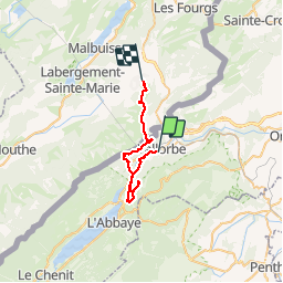
35 km | 53 km-effort
14h 41min
![](https://static1.geolcdn.com/siteimages/upload/files/16400158638029165_repeat_loop_refresh_sync_direction_icon.png)
Ja
![Tocht Te voet Vallorbe - Mont d'Orzeires - Le Pont Gare - Photo](https://media.geolcdn.com/t/375/260/7e9156be-5722-477c-ab77-407a4f623ffb.jpeg&format=jpg&maxdim=2)
![Te voet Te voet](https://static1.geolcdn.com/sitytour/trail-icons/100.png)
Mont d'Orzeires - Le Pont Gare
Te voet
Gemakkelijk
Vallorbe,
Waadland,
District du Jura-Nord vaudois,
Switzerland
![](/images/other/stat-length.png)
3,2 km | 4,4 km-effort
59min
![](https://static1.geolcdn.com/siteimages/upload/files/16400158638029165_repeat_loop_refresh_sync_direction_icon.png)
Neen
![Tocht Te voet Ballaigues - Ballaigues-Vallorbe - Photo](https://media.geolcdn.com/t/375/260/94e39ae2-cd96-4289-ab6b-b58b7f70c35d.jpeg&format=jpg&maxdim=2)
![Te voet Te voet](https://static1.geolcdn.com/sitytour/trail-icons/100.png)
Ballaigues-Vallorbe
Te voet
Gemakkelijk
Ballaigues,
Waadland,
District du Jura-Nord vaudois,
Switzerland
![](/images/other/stat-length.png)
5,1 km | 6,3 km-effort
1h 25min
![](https://static1.geolcdn.com/siteimages/upload/files/16400158638029165_repeat_loop_refresh_sync_direction_icon.png)
Neen
![Tocht Te voet Vallorbe - Saigne Geret-Les Revines - Photo](https://media.geolcdn.com/t/375/260/7e9156be-5722-477c-ab77-407a4f623ffb.jpeg&format=jpg&maxdim=2)
![Te voet Te voet](https://static1.geolcdn.com/sitytour/trail-icons/100.png)
Saigne Geret-Les Revines
Te voet
Gemakkelijk
Vallorbe,
Waadland,
District du Jura-Nord vaudois,
Switzerland
![](/images/other/stat-length.png)
3,5 km | 4,1 km-effort
56min
![](https://static1.geolcdn.com/siteimages/upload/files/16400158638029165_repeat_loop_refresh_sync_direction_icon.png)
Neen
![Tocht Te voet Juriens - TP Mollendruz - Romainmôtie - Photo](https://media.geolcdn.com/t/375/260/dev_7316eb13-f07d-4453-9d47-20985e85773c.jpeg&format=jpg&maxdim=2)
![Te voet Te voet](https://static1.geolcdn.com/sitytour/trail-icons/100.png)
TP Mollendruz - Romainmôtie
Te voet
Gemakkelijk
Juriens,
Waadland,
District du Jura-Nord vaudois,
Switzerland
![](/images/other/stat-length.png)
7,8 km | 11,6 km-effort
2h 38min
![](https://static1.geolcdn.com/siteimages/upload/files/16400158638029165_repeat_loop_refresh_sync_direction_icon.png)
Neen
![Tocht Stappen L'Abbaye - La Dent de Vaulion - Photo](https://media.geolcdn.com/t/375/260/d5e685b7-4a94-4c58-8eef-781dbd85a043.jpg&format=jpg&maxdim=2)
![Stappen Stappen](https://static1.geolcdn.com/sitytour/trail-icons/101.png)
La Dent de Vaulion
Stappen
Zeer moeilijk
(1)
L'Abbaye,
Waadland,
District du Jura-Nord vaudois,
Switzerland
![](/images/other/stat-length.png)
14,6 km | 22 km-effort
4h 31min
![](https://static1.geolcdn.com/siteimages/upload/files/16400158638029165_repeat_loop_refresh_sync_direction_icon.png)
Ja
![Tocht Stappen Métabief - Le mont d 0r - Photo](https://media.geolcdn.com/t/375/260/dfbdcbfb-f5e1-43ae-8768-86e7f8471cb6.jpg&format=jpg&maxdim=2)
![Stappen Stappen](https://static1.geolcdn.com/sitytour/trail-icons/101.png)
Le mont d 0r
Stappen
Medium
Métabief,
Bourgondië-Franche-Comté,
Doubs,
France
![](/images/other/stat-length.png)
18,5 km | 25 km-effort
4h 38min
![](https://static1.geolcdn.com/siteimages/upload/files/16400158638029165_repeat_loop_refresh_sync_direction_icon.png)
Neen
![Tocht Stappen Rochejean - Mont d'or - Photo](https://media.geolcdn.com/t/375/260/22137291-8125-4d4b-9cc5-d81179db76e3.jpg&format=jpg&maxdim=2)
![Stappen Stappen](https://static1.geolcdn.com/sitytour/trail-icons/101.png)
Mont d'or
Stappen
Gemakkelijk
Rochejean,
Bourgondië-Franche-Comté,
Doubs,
France
![](/images/other/stat-length.png)
11,9 km | 17,5 km-effort
4h 53min
![](https://static1.geolcdn.com/siteimages/upload/files/16400158638029165_repeat_loop_refresh_sync_direction_icon.png)
Ja
![Tocht Stappen Jougne - La Jougnena - Photo](https://media.geolcdn.com/t/375/260/ext.jpg?maxdim=2&url=https%3A%2F%2Fstatic1.geolcdn.com%2Fsiteimages%2Fupload%2Ffiles%2F1553511878bg_sport_marche.png)
![Stappen Stappen](https://static1.geolcdn.com/sitytour/trail-icons/101.png)
La Jougnena
Stappen
Zeer moeilijk
(1)
Jougne,
Bourgondië-Franche-Comté,
Doubs,
France
![](/images/other/stat-length.png)
17,7 km | 24 km-effort
5h 32min
![](https://static1.geolcdn.com/siteimages/upload/files/16400158638029165_repeat_loop_refresh_sync_direction_icon.png)
Ja