![](/images/other/stat-length.png)
![Tocht Stappen Laruns - AYOUS - Photo](https://media.geolcdn.com/t/1900/400/ext.pjpeg?maxdim=2&url=https%3A%2F%2Fstatic1.geolcdn.com%2Fsiteimages%2Fupload%2Ffiles%2F1553511878bg_sport_marche.png)
AYOUS
marmotte65
Gebruiker GUIDE
![Lengte](/images/other/stat-length.png)
Lengte
15,3 km
![Max. hoogte](https://static1.geolcdn.com/siteimages/upload/files/1508320355ic_sort_altitude_max_24dp.png)
Max. hoogte
2096 m
![Positief hoogteverschil](https://static1.geolcdn.com/siteimages/upload/files/1508320355ic_sort_den_pos_24dp.png)
Positief hoogteverschil
745 m
![Km-Effort](/images/other/stat-length.png)
Km-Effort
25 km
![Min. hoogte](https://static1.geolcdn.com/siteimages/upload/files/1508320355ic_sort_altitude_min_24dp.png)
Min. hoogte
1415 m
![Negatief hoogteverschil](https://static1.geolcdn.com/siteimages/upload/files/1508320355ic_sort_den_neg_24dp.png)
Negatief hoogteverschil
745 m
![Boucle](https://static1.geolcdn.com/siteimages/upload/files/16400158638029165_repeat_loop_refresh_sync_direction_icon.png)
Boucle
Ja
Datum van aanmaak :
2019-06-24 17:33:52.472
Laatste wijziging :
2020-01-10 14:53:15.229
![Stappen](https://static1.geolcdn.com/sitytour/trail-icons/101.png)
5h09
Moeilijkheid : Medium
![Scan deze QR-code om de tocht te openen in de SityTrail-applicatie](https://capi.geolives.com/qq0zvz2zws4bq2lad0pu/sitytour/trails/2123145/qr.png?size=200)
Gratisgps-wandelapplicatie
Over ons
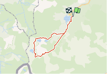
Tocht Stappen van 15,3 km beschikbaar op Nieuw-Aquitanië, Pyrénées-Atlantiques, Laruns. Deze tocht wordt voorgesteld door marmotte65.
Beschrijving
Balade Longue mais accessible a beaucoup de randonneur
magnifique points de vue sur le pic du midi d'Ossau dit Jean Pierre.
Plaatsbepaling
Land:
France
Regio :
Nieuw-Aquitanië
Departement/Provincie :
Pyrénées-Atlantiques
Gemeente :
Laruns
Locatie:
Unknown
Vertrek:(Dec)
Vertrek:(UTM)
708475 ; 4749336 (30T) N.
Opmerkingen
Wandeltochten in de omgeving
![Tocht Stappen Laruns - Ossau : Tour des lacs d’Ayous - Photo](https://media.geolcdn.com/t/375/260/506674d0-c4fd-4a53-a5f4-01b6386a74ed.jpg&format=jpg&maxdim=2)
![Stappen Stappen](https://static1.geolcdn.com/sitytour/trail-icons/101.png)
Ossau : Tour des lacs d’Ayous
Stappen
Medium
(1)
Laruns,
Nieuw-Aquitanië,
Pyrénées-Atlantiques,
France
![](/images/other/stat-length.png)
15,5 km | 25 km-effort
4h 49min
![](https://static1.geolcdn.com/siteimages/upload/files/16400158638029165_repeat_loop_refresh_sync_direction_icon.png)
Ja
![Tocht Stappen Laruns - Tour des Lacs d'Ayous en boucle depuis Bious-Artigues - Photo](https://media.geolcdn.com/t/375/260/ext.jpg?maxdim=2&url=https%3A%2F%2Fservices.sitytrail.com%2FGeolivesWS%2FDownloadMedia.ashx%3FTrailID%3D109944%26Media%3D5004_1.jpg)
![Stappen Stappen](https://static1.geolcdn.com/sitytour/trail-icons/101.png)
Tour des Lacs d'Ayous en boucle depuis Bious-Artigues
Stappen
Medium
(4)
Laruns,
Nieuw-Aquitanië,
Pyrénées-Atlantiques,
France
![](/images/other/stat-length.png)
14,1 km | 24 km-effort
5h 30min
![](https://static1.geolcdn.com/siteimages/upload/files/16400158638029165_repeat_loop_refresh_sync_direction_icon.png)
Ja
![Tocht Stappen Laruns - Tour des Lacs d'Ayous + Pic des Moines (2349m) - Photo](https://media.geolcdn.com/t/375/260/ext.jpg?maxdim=2&url=https%3A%2F%2Fservices.sitytrail.com%2FGeolivesWS%2FDownloadMedia.ashx%3FTrailID%3D103574%26Media%3D5886_1.jpg)
![Stappen Stappen](https://static1.geolcdn.com/sitytour/trail-icons/101.png)
Tour des Lacs d'Ayous + Pic des Moines (2349m)
Stappen
Moeilijk
(1)
Laruns,
Nieuw-Aquitanië,
Pyrénées-Atlantiques,
France
![](/images/other/stat-length.png)
15 km | 27 km-effort
5h 30min
![](https://static1.geolcdn.com/siteimages/upload/files/16400158638029165_repeat_loop_refresh_sync_direction_icon.png)
Ja
![Tocht Stappen Laruns - GR 10 - U - Photo](https://media.geolcdn.com/t/375/260/ext.jpg?maxdim=2&url=https%3A%2F%2Fstatic1.geolcdn.com%2Fsiteimages%2Fupload%2Ffiles%2F1553511878bg_sport_marche.png)
![Stappen Stappen](https://static1.geolcdn.com/sitytour/trail-icons/101.png)
GR 10 - U
Stappen
Zeer moeilijk
(1)
Laruns,
Nieuw-Aquitanië,
Pyrénées-Atlantiques,
France
![](/images/other/stat-length.png)
12,9 km | 26 km-effort
5h 1min
![](https://static1.geolcdn.com/siteimages/upload/files/16400158638029165_repeat_loop_refresh_sync_direction_icon.png)
Neen
![Tocht Stappen Laruns - chemin des fenetres - Photo](https://media.geolcdn.com/t/375/260/ext.jpg?maxdim=2&url=https%3A%2F%2Fstatic1.geolcdn.com%2Fsiteimages%2Fupload%2Ffiles%2F1553511878bg_sport_marche.png)
![Stappen Stappen](https://static1.geolcdn.com/sitytour/trail-icons/101.png)
chemin des fenetres
Stappen
Gemakkelijk
(1)
Laruns,
Nieuw-Aquitanië,
Pyrénées-Atlantiques,
France
![](/images/other/stat-length.png)
8 km | 14,1 km-effort
3h 0min
![](https://static1.geolcdn.com/siteimages/upload/files/16400158638029165_repeat_loop_refresh_sync_direction_icon.png)
Neen
![Tocht sport Laruns - Gabas Etsaut - Photo](https://media.geolcdn.com/t/375/260/7c21af10-1d22-476f-b216-9aa4a04acfe4.jpg&format=jpg&maxdim=2)
Gabas Etsaut
sport
Heel gemakkelijk
Laruns,
Nieuw-Aquitanië,
Pyrénées-Atlantiques,
France
![](/images/other/stat-length.png)
26 km | 44 km-effort
Onbekend
![](https://static1.geolcdn.com/siteimages/upload/files/16400158638029165_repeat_loop_refresh_sync_direction_icon.png)
Neen
![Tocht Stappen Laruns - Lac d’Aule et Col du Turin Garié - Photo](https://media.geolcdn.com/t/375/260/5b20a947-15d2-453e-9b90-ef85d05c68e0.jpg&format=jpg&maxdim=2)
![Stappen Stappen](https://static1.geolcdn.com/sitytour/trail-icons/101.png)
Lac d’Aule et Col du Turin Garié
Stappen
Moeilijk
Laruns,
Nieuw-Aquitanië,
Pyrénées-Atlantiques,
France
![](/images/other/stat-length.png)
11,7 km | 25 km-effort
5h 37min
![](https://static1.geolcdn.com/siteimages/upload/files/16400158638029165_repeat_loop_refresh_sync_direction_icon.png)
Ja
![Tocht Stappen Laruns - lacs d'Ayous - Photo](https://media.geolcdn.com/t/375/260/dd136f74-904d-495b-bdb2-8389a76c47db.jpg&format=jpg&maxdim=2)
![Stappen Stappen](https://static1.geolcdn.com/sitytour/trail-icons/101.png)
lacs d'Ayous
Stappen
Zeer moeilijk
Laruns,
Nieuw-Aquitanië,
Pyrénées-Atlantiques,
France
![](/images/other/stat-length.png)
14,5 km | 24 km-effort
7h 33min
![](https://static1.geolcdn.com/siteimages/upload/files/16400158638029165_repeat_loop_refresh_sync_direction_icon.png)
Ja
![Tocht Te voet Laruns - Voie d'OssauB - Photo](https://media.geolcdn.com/t/375/260/7ccbfa81-52aa-450a-9353-320987110b82.jpeg&format=jpg&maxdim=2)
![Te voet Te voet](https://static1.geolcdn.com/sitytour/trail-icons/100.png)
Voie d'OssauB
Te voet
Medium
Laruns,
Nieuw-Aquitanië,
Pyrénées-Atlantiques,
France
![](/images/other/stat-length.png)
14,1 km | 24 km-effort
5h 32min
![](https://static1.geolcdn.com/siteimages/upload/files/16400158638029165_repeat_loop_refresh_sync_direction_icon.png)
Neen