![](/images/other/stat-length.png)
CC_Velay_GB_29_Lichos_Ostabat-Asme_20090413
patrickdanilo
Gebruiker
![Lengte](/images/other/stat-length.png)
Lengte
28 km
![Max. hoogte](https://static1.geolcdn.com/siteimages/upload/files/1508320355ic_sort_altitude_max_24dp.png)
Max. hoogte
291 m
![Positief hoogteverschil](https://static1.geolcdn.com/siteimages/upload/files/1508320355ic_sort_den_pos_24dp.png)
Positief hoogteverschil
765 m
![Km-Effort](/images/other/stat-length.png)
Km-Effort
38 km
![Min. hoogte](https://static1.geolcdn.com/siteimages/upload/files/1508320355ic_sort_altitude_min_24dp.png)
Min. hoogte
64 m
![Negatief hoogteverschil](https://static1.geolcdn.com/siteimages/upload/files/1508320355ic_sort_den_neg_24dp.png)
Negatief hoogteverschil
714 m
![Boucle](https://static1.geolcdn.com/siteimages/upload/files/16400158638029165_repeat_loop_refresh_sync_direction_icon.png)
Boucle
Neen
Datum van aanmaak :
2019-06-23 15:08:34.326
Laatste wijziging :
2022-09-19 14:44:30.784
![Stappen](https://static1.geolcdn.com/sitytour/trail-icons/101.png)
7h30
Moeilijkheid : Medium
![Scan deze QR-code om de tocht te openen in de SityTrail-applicatie](https://capi.geolives.com/qq0zvz2zws4bq2lad0pu/sitytour/trails/2121953/qr.png?size=200)
Gratisgps-wandelapplicatie
Over ons
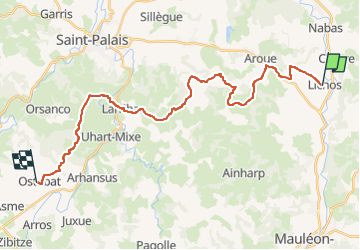
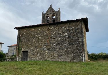
Tocht Stappen van 28 km beschikbaar op Nieuw-Aquitanië, Pyrénées-Atlantiques, Lichos. Deze tocht wordt voorgesteld door patrickdanilo.
Beschrijving
Randonnée Marche de 28 km à découvrir à Nouvelle-Aquitaine, Pyrénées-Atlantiques, Lichos. Cette randonnée est proposée par patrickdanilo.
Plaatsbepaling
Land:
France
Regio :
Nieuw-Aquitanië
Departement/Provincie :
Pyrénées-Atlantiques
Gemeente :
Lichos
Locatie:
Unknown
Vertrek:(Dec)
Vertrek:(UTM)
672216 ; 4796791 (30T) N.
Opmerkingen
Wandeltochten in de omgeving
![Tocht Stappen Lichos - Mon Compostelle Quinzième étape - Photo](https://media.geolcdn.com/t/375/260/ext.jpg?maxdim=2&url=https%3A%2F%2Fservices.sitytrail.com%2FGeolivesWS%2FDownloadMedia.ashx%3FTrailID%3D686135%26Media%3Df2ef0261-7305-413e-aa06-bb85dda5e3d7.JPG)
![Stappen Stappen](https://static1.geolcdn.com/sitytour/trail-icons/101.png)
Mon Compostelle Quinzième étape
Stappen
Zeer moeilijk
Lichos,
Nieuw-Aquitanië,
Pyrénées-Atlantiques,
France
![](/images/other/stat-length.png)
52 km | 67 km-effort
10h 25min
![](https://static1.geolcdn.com/siteimages/upload/files/16400158638029165_repeat_loop_refresh_sync_direction_icon.png)
Neen
![Tocht Stappen Charritte-de-Bas - 8 charritte - Photo](https://media.geolcdn.com/t/375/260/0daae758-4f70-43de-89ad-21ec00604d6a.jpg&format=jpg&maxdim=2)
![Stappen Stappen](https://static1.geolcdn.com/sitytour/trail-icons/101.png)
8 charritte
Stappen
Moeilijk
Charritte-de-Bas,
Nieuw-Aquitanië,
Pyrénées-Atlantiques,
France
![](/images/other/stat-length.png)
23 km | 30 km-effort
7h 4min
![](https://static1.geolcdn.com/siteimages/upload/files/16400158638029165_repeat_loop_refresh_sync_direction_icon.png)
Neen
![Tocht Stappen Lichos - GR 65 Lichos > Ahransus - Photo](https://media.geolcdn.com/t/375/260/b046605f-229a-4aba-8d1e-52855b0e3e88.jpg&format=jpg&maxdim=2)
![Stappen Stappen](https://static1.geolcdn.com/sitytour/trail-icons/101.png)
GR 65 Lichos > Ahransus
Stappen
Gemakkelijk
Lichos,
Nieuw-Aquitanië,
Pyrénées-Atlantiques,
France
![](/images/other/stat-length.png)
23 km | 30 km-effort
5h 22min
![](https://static1.geolcdn.com/siteimages/upload/files/16400158638029165_repeat_loop_refresh_sync_direction_icon.png)
Neen
![Tocht Stappen Aroue-Ithorots-Olhaïby - Compostelle Aroue Larceveau - Photo](https://media.geolcdn.com/t/375/260/ext.jpg?maxdim=2&url=https%3A%2F%2Fstatic1.geolcdn.com%2Fsiteimages%2Fupload%2Ffiles%2F1553511878bg_sport_marche.png)
![Stappen Stappen](https://static1.geolcdn.com/sitytour/trail-icons/101.png)
Compostelle Aroue Larceveau
Stappen
Moeilijk
Aroue-Ithorots-Olhaïby,
Nieuw-Aquitanië,
Pyrénées-Atlantiques,
France
![](/images/other/stat-length.png)
31 km | 41 km-effort
6h 38min
![](https://static1.geolcdn.com/siteimages/upload/files/16400158638029165_repeat_loop_refresh_sync_direction_icon.png)
Neen
![Tocht Stappen Aroue-Ithorots-Olhaïby - Camino 1 étape 30 du 24.08.2023 - Photo](https://media.geolcdn.com/t/375/260/ext.jpg?maxdim=2&url=https%3A%2F%2Fstatic1.geolcdn.com%2Fsiteimages%2Fupload%2Ffiles%2F1553511878bg_sport_marche.png)
![Stappen Stappen](https://static1.geolcdn.com/sitytour/trail-icons/101.png)
Camino 1 étape 30 du 24.08.2023
Stappen
Medium
Aroue-Ithorots-Olhaïby,
Nieuw-Aquitanië,
Pyrénées-Atlantiques,
France
![](/images/other/stat-length.png)
24 km | 33 km-effort
8h 58min
![](https://static1.geolcdn.com/siteimages/upload/files/16400158638029165_repeat_loop_refresh_sync_direction_icon.png)
Neen
![Tocht Stappen Lichos - StJ-J43-Lichos-Ostabat - Photo](https://media.geolcdn.com/t/375/260/ext.jpg?maxdim=2&url=https%3A%2F%2Fstatic1.geolcdn.com%2Fsiteimages%2Fupload%2Ffiles%2F1553511878bg_sport_marche.png)
![Stappen Stappen](https://static1.geolcdn.com/sitytour/trail-icons/101.png)
StJ-J43-Lichos-Ostabat
Stappen
Heel gemakkelijk
Lichos,
Nieuw-Aquitanië,
Pyrénées-Atlantiques,
France
![](/images/other/stat-length.png)
25 km | 34 km-effort
7h 3min
![](https://static1.geolcdn.com/siteimages/upload/files/16400158638029165_repeat_loop_refresh_sync_direction_icon.png)
Neen
![Tocht Stappen Aroue-Ithorots-Olhaïby - St Jacques Etape 35 - Photo](https://media.geolcdn.com/t/375/260/ext.jpg?maxdim=2&url=https%3A%2F%2Fstatic1.geolcdn.com%2Fsiteimages%2Fupload%2Ffiles%2F1553511878bg_sport_marche.png)
![Stappen Stappen](https://static1.geolcdn.com/sitytour/trail-icons/101.png)
St Jacques Etape 35
Stappen
Gemakkelijk
Aroue-Ithorots-Olhaïby,
Nieuw-Aquitanië,
Pyrénées-Atlantiques,
France
![](/images/other/stat-length.png)
29 km | 39 km-effort
8h 12min
![](https://static1.geolcdn.com/siteimages/upload/files/16400158638029165_repeat_loop_refresh_sync_direction_icon.png)
Neen
![Tocht Stappen Charritte-de-Bas - lichos/st Palais - Photo](https://media.geolcdn.com/t/375/260/ext.jpg?maxdim=2&url=https%3A%2F%2Fstatic1.geolcdn.com%2Fsiteimages%2Fupload%2Ffiles%2F1553511878bg_sport_marche.png)
![Stappen Stappen](https://static1.geolcdn.com/sitytour/trail-icons/101.png)
lichos/st Palais
Stappen
Gemakkelijk
Charritte-de-Bas,
Nieuw-Aquitanië,
Pyrénées-Atlantiques,
France
![](/images/other/stat-length.png)
24 km | 31 km-effort
6h 37min
![](https://static1.geolcdn.com/siteimages/upload/files/16400158638029165_repeat_loop_refresh_sync_direction_icon.png)
Neen
![Tocht Noords wandelen Aroue-Ithorots-Olhaïby - De Landaco à Harembeltz vendredi 6 juillet - Photo](https://media.geolcdn.com/t/375/260/ext.jpg?maxdim=2&url=https%3A%2F%2Fstatic1.geolcdn.com%2Fsiteimages%2Fupload%2Ffiles%2F1545311037marcheuse_200dpi.jpg)
![Noords wandelen Noords wandelen](https://static1.geolcdn.com/sitytour/trail-icons/102.png)
De Landaco à Harembeltz vendredi 6 juillet
Noords wandelen
Medium
Aroue-Ithorots-Olhaïby,
Nieuw-Aquitanië,
Pyrénées-Atlantiques,
France
![](/images/other/stat-length.png)
21 km | 28 km-effort
8h 4min
![](https://static1.geolcdn.com/siteimages/upload/files/16400158638029165_repeat_loop_refresh_sync_direction_icon.png)
Neen