Tocht Mountainbike Les Angles - les anglesrefuge liadura cmporels retour formiguere - Photo

les anglesrefuge liadura cmporels retour formiguere

 andolphy
andolphy

Gebruiker

© OpenStreetMap contributors
Lengte
Lengte
42 km
Max. hoogte
Max. hoogte
2415 m
Positief hoogteverschil
1403 m
Km-Effort
Km-Effort  
61 km
Min. hoogte
Min. hoogte
1536 m
Negatief hoogteverschil
1414 m
Boucle
Boucle
Ja
Datum van aanmaak :
2019-06-10 16:28:38.978
Laatste wijziging :
2019-06-10 16:39:04.247

(0 Bericht)

Mountainbike
Mountainbike
3h52
Moeilijkheid : Zeer moeilijk

Scan deze QR-code om de tocht te openen in de SityTrail-applicatie

Gratisgps-wandelapplicatie

Logo SityTrail SityTrail

IGN / Geografische instituten

SityTrail uit de App Store downloaden SityTrail uit Google Play downloaden

Logo SityTrail SityTrail World

De wereld gaat voor u open

SityTrail uit de App Store downloaden SityTrail uit Google Play downloaden SityTrail op Huawei AppGallery downloaden

Over ons

Tocht Mountainbike van 42 km beschikbaar op Occitanië, Pyrénées-Orientales, Les Angles. Deze tocht wordt voorgesteld door andolphy.

Beschrijving

difficile gros denivele et longue ça ce merite que du bonheur

Hoogteprofiel

Plaatsbepaling

Land:
France
Regio :
Occitanië
Departement/Provincie :
Pyrénées-Orientales
Gemeente :
Les Angles
Locatie:
Unknown
Vertrek:(UTM)
423896 ; 4714334 (31T) N.

Wandeltochten in de omgeving

Tocht Stappen Font-Romeu-Odeillo-Via - Coll del Pam lac des  Bouillouses - Photo
Stappen
jcmartin

Stappen

Medium
(2)
Font-Romeu-Odeillo-Via, Occitanië, Pyrénées-Orientales, France
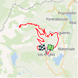
13,3 km | 19,3 km-effort
4h 10min
Ja
Tocht Sneeuwschoenen Les Angles - Lac d Aude -Refuge Bernardi les Angles - Photo
Sneeuwschoenen
MarieFrancoise

Sneeuwschoenen

Medium
(1)
Les Angles, Occitanië, Pyrénées-Orientales, France
13,9 km | 19,1 km-effort
5h 44min
Ja
Tocht Stappen Les Angles - lac d'Aude  - Photo
Stappen
GUIDE
nadinebondoux

Stappen

Medium
Les Angles, Occitanië, Pyrénées-Orientales, France
13,8 km | 0 m-effort
5h 57min
Ja
Tocht Stappen Les Angles - Lac d'Aude en boucle - Photo
Stappen
GUIDE
nadinebondoux

Stappen

Medium
Les Angles, Occitanië, Pyrénées-Orientales, France
13,8 km | 19,9 km-effort
6h 8min
Ja
Tocht Stappen Les Angles - les Angles - Photo
Stappen
GUIDE
nadinebondoux

Stappen

Moeilijk
Les Angles, Occitanië, Pyrénées-Orientales, France
14,5 km | 20 km-effort
4h 58min
Neen
Tocht Stappen Formiguères - Les Camporells par la Lladure  - Photo
Stappen
jcmartin

Stappen

Medium
(1)
Formiguères, Occitanië, Pyrénées-Orientales, France
15,1 km | 24 km-effort
5h 7min
Ja
Tocht Sneeuwschoenen Les Angles - lac d aude - Photo
Sneeuwschoenen
xav34830

Sneeuwschoenen

Heel gemakkelijk
(2)
Les Angles, Occitanië, Pyrénées-Orientales, France
14,5 km | 20 km-effort
Onbekend
Ja
Tocht Stappen Les Angles - boucle de la Balmette par le mont Llaret et le roc d'aude - Photo
Stappen
Axelloceane

Stappen

Medium
(2)
Les Angles, Occitanië, Pyrénées-Orientales, France
17,2 km | 28 km-effort
Onbekend
Ja
Tocht Stappen La Llagonne - 2024-01-22 Les bouillouses  - Photo
Stappen
eric.mignot

Stappen

Moeilijk
La Llagonne, Occitanië, Pyrénées-Orientales, France
10,3 km | 15 km-effort
3h 25min
Ja


Sluiten
Mijn abonnementen