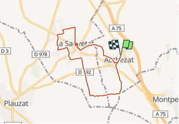
![](/images/other/stat-length.png)
![Tocht Stappen Authezat - Authezat_Forts_Sauvetat - Photo](https://media.geolcdn.com/t/1900/400/292191a2-574c-43c7-98a7-2f59658ff2bc.jpg&format=pjpeg&maxdim=2)
Authezat_Forts_Sauvetat
jagarnier
Gebruiker GUIDE
![Lengte](/images/other/stat-length.png)
![Max. hoogte](https://static1.geolcdn.com/siteimages/upload/files/1508320355ic_sort_altitude_max_24dp.png)
![Positief hoogteverschil](https://static1.geolcdn.com/siteimages/upload/files/1508320355ic_sort_den_pos_24dp.png)
![Km-Effort](/images/other/stat-length.png)
![Min. hoogte](https://static1.geolcdn.com/siteimages/upload/files/1508320355ic_sort_altitude_min_24dp.png)
![Negatief hoogteverschil](https://static1.geolcdn.com/siteimages/upload/files/1508320355ic_sort_den_neg_24dp.png)
![Boucle](https://static1.geolcdn.com/siteimages/upload/files/16400158638029165_repeat_loop_refresh_sync_direction_icon.png)
![Stappen](https://static1.geolcdn.com/sitytour/trail-icons/101.png)
2h15
Moeilijkheid : Gemakkelijk
![Scan deze QR-code om de tocht te openen in de SityTrail-applicatie](https://capi.geolives.com/qq0zvz2zws4bq2lad0pu/sitytour/trails/2097311/qr.png?size=200)
Gratisgps-wandelapplicatie
Over ons
Tocht Stappen van 7,3 km beschikbaar op Auvergne-Rhône-Alpes, Puy-de-Dôme, Authezat. Deze tocht wordt voorgesteld door jagarnier.
Beschrijving
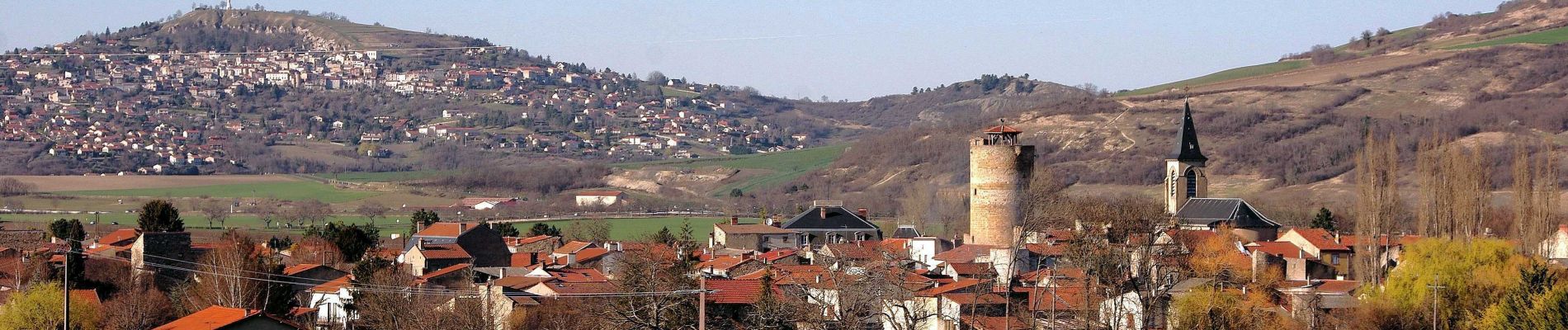
Les chemins sont les allées d'un grand jardin où il fait bon sentir le parfum des saisons. Les couleurs changent au gré des céréales, des noyers ou des vignes. Les églises d'Authezat (11ème et 14ème siècles) et l'ancienne commanderie des Hospitaliers à La Sauvetat nous font voyager dans le temps.
Plaatsbepaling
Opmerkingen
Wandeltochten in de omgeving
![Tocht Stappen Champeix - Champeix_St_Julien - Photo](https://media.geolcdn.com/t/375/260/42c319f4-7a47-48dd-bf0b-2587fad533a9.jpg&format=jpg&maxdim=2)
![Stappen Stappen](https://static1.geolcdn.com/sitytour/trail-icons/101.png)
Stappen
![](/images/other/stat-length.png)
![](https://static1.geolcdn.com/siteimages/upload/files/16400158638029165_repeat_loop_refresh_sync_direction_icon.png)
![Stappen Stappen](https://static1.geolcdn.com/sitytour/trail-icons/101.png)
Stappen
![](/images/other/stat-length.png)
![](https://static1.geolcdn.com/siteimages/upload/files/16400158638029165_repeat_loop_refresh_sync_direction_icon.png)
![Stappen Stappen](https://static1.geolcdn.com/sitytour/trail-icons/101.png)
Stappen
![](/images/other/stat-length.png)
![](https://static1.geolcdn.com/siteimages/upload/files/16400158638029165_repeat_loop_refresh_sync_direction_icon.png)
![Tocht Stappen Parent - Parent_Montpeyroux - Photo](https://media.geolcdn.com/t/375/260/5d7d75da-6cfd-4cb5-a3d3-b6ff5a686467.jpg&format=jpg&maxdim=2)
![Stappen Stappen](https://static1.geolcdn.com/sitytour/trail-icons/101.png)
Stappen
![](/images/other/stat-length.png)
![](https://static1.geolcdn.com/siteimages/upload/files/16400158638029165_repeat_loop_refresh_sync_direction_icon.png)
![Tocht Stappen Vic-le-Comte - Entre vignes et comté - Photo](https://media.geolcdn.com/t/375/260/ext.jpg?maxdim=2&url=https%3A%2F%2Fservices.sitytrail.com%2FGeolivesWS%2FDownloadMedia.ashx%3FTrailID%3D102016%26Media%3D2322_2.jpg)
![Stappen Stappen](https://static1.geolcdn.com/sitytour/trail-icons/101.png)
Stappen
![](/images/other/stat-length.png)
![](https://static1.geolcdn.com/siteimages/upload/files/16400158638029165_repeat_loop_refresh_sync_direction_icon.png)
![Tocht Te voet Montpeyroux - Montpeyroux - Photo](https://media.geolcdn.com/t/375/260/a7bba57e-1073-43f5-8adc-862b103ee316.jpeg&format=jpg&maxdim=2)
![Te voet Te voet](https://static1.geolcdn.com/sitytour/trail-icons/100.png)
Te voet
![](/images/other/stat-length.png)
![](https://static1.geolcdn.com/siteimages/upload/files/16400158638029165_repeat_loop_refresh_sync_direction_icon.png)
![Tocht Te voet Authezat - Sur le Chemin de l'Arkose - Photo](https://media.geolcdn.com/t/375/260/f00cf124-c43c-453c-a0c8-824c03b3ba30.jpeg&format=jpg&maxdim=2)
![Te voet Te voet](https://static1.geolcdn.com/sitytour/trail-icons/100.png)
Te voet
![](/images/other/stat-length.png)
![](https://static1.geolcdn.com/siteimages/upload/files/16400158638029165_repeat_loop_refresh_sync_direction_icon.png)
![Tocht Te voet Yronde-et-Buron - L'Abbaye du Bouschet - Photo](https://media.geolcdn.com/t/375/260/50cfacdd-f92e-4973-88f2-43faafdab62f.jpeg&format=jpg&maxdim=2)
![Te voet Te voet](https://static1.geolcdn.com/sitytour/trail-icons/100.png)
Te voet
![](/images/other/stat-length.png)
![](https://static1.geolcdn.com/siteimages/upload/files/16400158638029165_repeat_loop_refresh_sync_direction_icon.png)
![Tocht Te voet Yronde-et-Buron - La Citadelle de Buron - Photo](https://media.geolcdn.com/t/375/260/d0b37edd-ef3f-469d-9576-5c41af0df209.jpeg&format=jpg&maxdim=2)
![Te voet Te voet](https://static1.geolcdn.com/sitytour/trail-icons/100.png)
Te voet
![](/images/other/stat-length.png)
![](https://static1.geolcdn.com/siteimages/upload/files/16400158638029165_repeat_loop_refresh_sync_direction_icon.png)