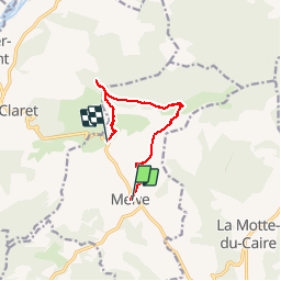
![](/images/other/stat-length.png)
![Tocht Stappen Melve - Melve Rando Pivoines, avec la RSPG : https://www.rspg05.org/ - Photo](https://media.geolcdn.com/t/1900/400/d79f0681-8663-4e9d-b91d-6ba336eb6feb.jpg&format=pjpeg&maxdim=2)
Melve Rando Pivoines, avec la RSPG : https://www.rspg05.org/
Daniel.BRUN-PICARD
Gebruiker
![Lengte](/images/other/stat-length.png)
![Max. hoogte](https://static1.geolcdn.com/siteimages/upload/files/1508320355ic_sort_altitude_max_24dp.png)
![Positief hoogteverschil](https://static1.geolcdn.com/siteimages/upload/files/1508320355ic_sort_den_pos_24dp.png)
![Km-Effort](/images/other/stat-length.png)
![Min. hoogte](https://static1.geolcdn.com/siteimages/upload/files/1508320355ic_sort_altitude_min_24dp.png)
![Negatief hoogteverschil](https://static1.geolcdn.com/siteimages/upload/files/1508320355ic_sort_den_neg_24dp.png)
![Boucle](https://static1.geolcdn.com/siteimages/upload/files/16400158638029165_repeat_loop_refresh_sync_direction_icon.png)
![Stappen](https://static1.geolcdn.com/sitytour/trail-icons/101.png)
5h13
Moeilijkheid : Medium
![Scan deze QR-code om de tocht te openen in de SityTrail-applicatie](https://capi.geolives.com/qq0zvz2zws4bq2lad0pu/sitytour/trails/2094586/qr.png?size=200)
Gratisgps-wandelapplicatie
Over ons
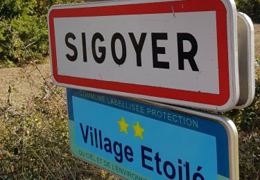
Tocht Stappen van 8,3 km beschikbaar op Provence-Alpes-Côte d'Azur, Alpes-de-Haute-Provence, Melve. Deze tocht wordt voorgesteld door Daniel.BRUN-PICARD.
Beschrijving
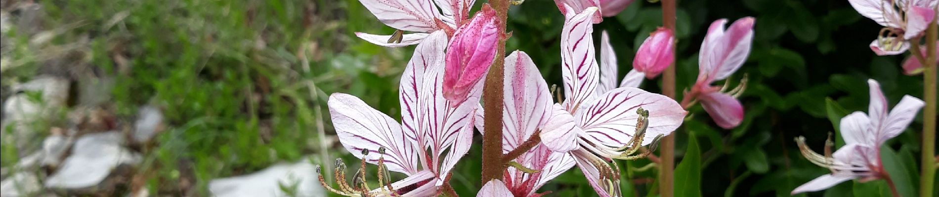
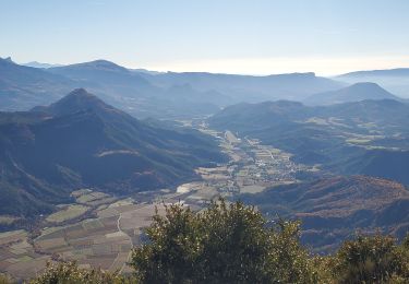
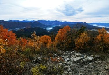
Très belle randonnée de printemps, à faire mi-mai. On trouve des fleurs à profusion : Pivoines, orchis, muguets, fraxinelles...
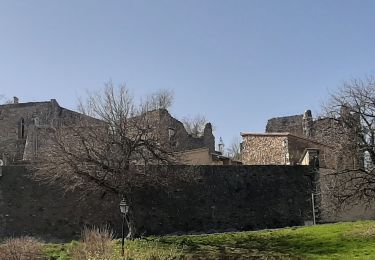
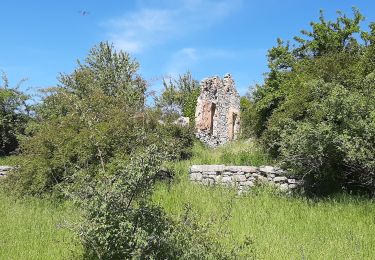
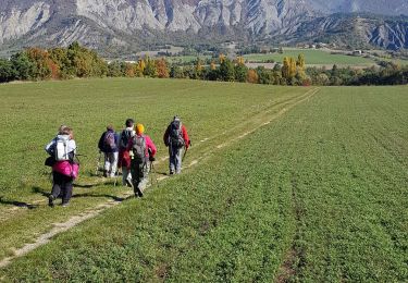
Il y a, après la tour en ruine, un passage en arête et quelques passages en dévers un peu impressionnants, mais sans difficulté. Les bâtons de randonnée sont fortement recommandés, d'autant plus que les montées et descentes sont assez raides : 600 m de dénivelé en 8 km !
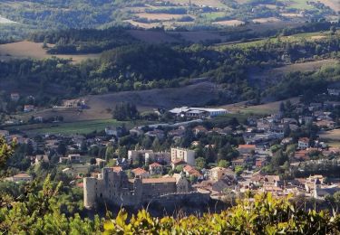
Pour éviter 3km de marche sur route, nous avons garé un véhicule au point d'arrivée, lieu dit "Chemin de la plane" et rejoint le point de départ à Melve avec un deuxième véhicule.
Plaatsbepaling
Opmerkingen
Wandeltochten in de omgeving
![Tocht Stappen Sigoyer - SIGOYER Boucle Croix de la Biousse o l m s - Photo](https://media.geolcdn.com/t/375/260/cc06d09a-5ff2-41a1-9edb-f8368db9ba2d.jpg&format=jpg&maxdim=2)
![Stappen Stappen](https://static1.geolcdn.com/sitytour/trail-icons/101.png)
Stappen
![](/images/other/stat-length.png)
![](https://static1.geolcdn.com/siteimages/upload/files/16400158638029165_repeat_loop_refresh_sync_direction_icon.png)
![Tocht Stappen La Motte-du-Caire - LA MOTTE DU CAIRE .Le tour de la Blachere o - Photo](https://media.geolcdn.com/t/375/260/181c511a-92a7-4933-9888-9e2bc6024806.jpg&format=jpg&maxdim=2)
![Stappen Stappen](https://static1.geolcdn.com/sitytour/trail-icons/101.png)
Stappen
![](/images/other/stat-length.png)
![](https://static1.geolcdn.com/siteimages/upload/files/16400158638029165_repeat_loop_refresh_sync_direction_icon.png)
![Tocht Stappen Melve - Melve Les Chanderettes 1014m 16kms - Photo](https://media.geolcdn.com/t/375/260/ccabf33a-e431-4ec0-8bfa-bcf63e55d70b.jpg&format=jpg&maxdim=2)
![Stappen Stappen](https://static1.geolcdn.com/sitytour/trail-icons/101.png)
Stappen
![](/images/other/stat-length.png)
![](https://static1.geolcdn.com/siteimages/upload/files/16400158638029165_repeat_loop_refresh_sync_direction_icon.png)
![Tocht Stappen Sigoyer - Sigoyer Les Baudes - Photo](https://media.geolcdn.com/t/375/260/a01c5cb6-bdb8-480b-87fa-564c7d11bb21.jpg&format=jpg&maxdim=2)
![Stappen Stappen](https://static1.geolcdn.com/sitytour/trail-icons/101.png)
Stappen
![](/images/other/stat-length.png)
![](https://static1.geolcdn.com/siteimages/upload/files/16400158638029165_repeat_loop_refresh_sync_direction_icon.png)
![Tocht Stappen Claret - Tete de Boursier depart Claret - Photo](https://media.geolcdn.com/t/375/260/c93a942b-9518-4b3c-80a9-c6f6ef8e8c48.jpg&format=jpg&maxdim=2)
![Stappen Stappen](https://static1.geolcdn.com/sitytour/trail-icons/101.png)
Stappen
![](/images/other/stat-length.png)
![](https://static1.geolcdn.com/siteimages/upload/files/16400158638029165_repeat_loop_refresh_sync_direction_icon.png)
![Tocht Stappen Thèze - Boucle Theze Sigoyer depart Theze - Photo](https://media.geolcdn.com/t/375/260/91670e8d-b25b-43eb-b3a3-a9631c3bd51e.jpg&format=jpg&maxdim=2)
![Stappen Stappen](https://static1.geolcdn.com/sitytour/trail-icons/101.png)
Stappen
![](/images/other/stat-length.png)
![](https://static1.geolcdn.com/siteimages/upload/files/16400158638029165_repeat_loop_refresh_sync_direction_icon.png)
![Tocht Stappen Sigoyer - Boucle Croix de la Biousse - Photo](https://media.geolcdn.com/t/375/260/9bf7cebd-6a47-4b2b-a790-11caea904f86.jpg&format=jpg&maxdim=2)
![Stappen Stappen](https://static1.geolcdn.com/sitytour/trail-icons/101.png)
Stappen
![](/images/other/stat-length.png)
![](https://static1.geolcdn.com/siteimages/upload/files/16400158638029165_repeat_loop_refresh_sync_direction_icon.png)
![Tocht Stappen Melve - 20191126_Melve Tête de Boursier - Photo](https://media.geolcdn.com/t/375/260/1d6a6e93-136f-4ae8-96da-7f5812d2bd56.jpg&format=jpg&maxdim=2)
![Stappen Stappen](https://static1.geolcdn.com/sitytour/trail-icons/101.png)
Stappen
![](/images/other/stat-length.png)
![](https://static1.geolcdn.com/siteimages/upload/files/16400158638029165_repeat_loop_refresh_sync_direction_icon.png)
![Stappen Stappen](https://static1.geolcdn.com/sitytour/trail-icons/101.png)
Stappen
![](/images/other/stat-length.png)
![](https://static1.geolcdn.com/siteimages/upload/files/16400158638029165_repeat_loop_refresh_sync_direction_icon.png)