![](/images/other/stat-length.png)
![Tocht Fiets Mümliswil-Ramiswil - 010CH07 3 Passwang - Mervelier - Photo](https://media.geolcdn.com/t/1900/400/ext.pjpeg?maxdim=2&url=https%3A%2F%2Fstatic1.geolcdn.com%2Fsiteimages%2Fupload%2Ffiles%2F1524743154velo.jpg)
010CH07 3 Passwang - Mervelier
LCGsell
Gebruiker
![Lengte](/images/other/stat-length.png)
![Max. hoogte](https://static1.geolcdn.com/siteimages/upload/files/1508320355ic_sort_altitude_max_24dp.png)
![Positief hoogteverschil](https://static1.geolcdn.com/siteimages/upload/files/1508320355ic_sort_den_pos_24dp.png)
![Km-Effort](/images/other/stat-length.png)
![Min. hoogte](https://static1.geolcdn.com/siteimages/upload/files/1508320355ic_sort_altitude_min_24dp.png)
![Negatief hoogteverschil](https://static1.geolcdn.com/siteimages/upload/files/1508320355ic_sort_den_neg_24dp.png)
![Boucle](https://static1.geolcdn.com/siteimages/upload/files/16400158638029165_repeat_loop_refresh_sync_direction_icon.png)
![Fiets](https://static1.geolcdn.com/sitytour/trail-icons/200.png)
--
Moeilijkheid : Onbekend
![Scan deze QR-code om de tocht te openen in de SityTrail-applicatie](https://capi.geolives.com/qq0zvz2zws4bq2lad0pu/sitytour/trails/20943/qr.png?size=200)
Gratisgps-wandelapplicatie
Over ons
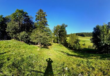
Tocht Fiets van 18,4 km beschikbaar op Solothurn, Bezirk Thal, Mümliswil-Ramiswil. Deze tocht wordt voorgesteld door LCGsell.
Beschrijving
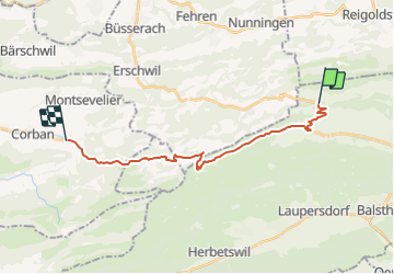
Dritte Strecke der Etappe 010CH07 von Basel nach Biel
Durchs kurze Tunnel erreicht man die Jura Südseite und das Restaurant für Töffs und Autos. Der gute Strassenbelag ermöglicht rassiges Abfahren auf der breiten Strasse mit den grosszügigen Kurvenradien, darf aber die Abzweigung ins Guldental nicht verpassen. Es hilft voraus zu sehen und schon während der Abfahrt einen Blick nach rechts, das Guldental hinauf zum Scheltenpass zu werfen, ohne sich dabei auf die Strasse .... Also bremsen und rechts ins Guldental, vorerst noch flach. Linker Hand lädt der Bauernhof mit Restaurant zum Mittagessen ein, dann geht es aber hinauf durch Wald und Feld. Kurz vor dem letzten Anstieg im Hof Hinteres Guldental gibt es nochmals Verpflegungs Möglichkeit. Die letzten hundert Meter sind die steilsten. Auch der Scheltenpass ist ein Ausgangspunkt zum Wandern. Zum Beispiel hinüber zum südlichen Brunnersberg oder diesseits auf die Hohe Winde, Aussichtspunkte mit netten Bergwirtschaften an der Basis. Die lange Abfahrt ist auf engem Strässchen, vorerst im offenen Gelände, dann in enger Gemeinschaft mit dem Scheltenbach und schliesslich erreicht mann Mervelier am Ende der durchquerten Schlucht.
Schnell 1h30, langsam 2h
Plaatsbepaling
Opmerkingen
Wandeltochten in de omgeving
![Tocht Te voet - Gondelbahn - Wasserfallen - Photo](https://media.geolcdn.com/t/375/260/5b91cc13-ed8d-4eb3-9692-9dcec32168f3.jpeg&format=jpg&maxdim=2)
![Te voet Te voet](https://static1.geolcdn.com/sitytour/trail-icons/100.png)
Te voet
![](/images/other/stat-length.png)
![](https://static1.geolcdn.com/siteimages/upload/files/16400158638029165_repeat_loop_refresh_sync_direction_icon.png)
![Tocht Te voet Beinwil (SO) - Vorder Erzberg - Zingelen - Photo](https://media.geolcdn.com/t/375/260/b6e298d5-0559-4553-ac29-f19aa3740615.jpeg&format=jpg&maxdim=2)
![Te voet Te voet](https://static1.geolcdn.com/sitytour/trail-icons/100.png)
Te voet
![](/images/other/stat-length.png)
![](https://static1.geolcdn.com/siteimages/upload/files/16400158638029165_repeat_loop_refresh_sync_direction_icon.png)
![Tocht Te voet Balsthal - St. Wolfgang - Langenbruck - Photo](https://media.geolcdn.com/t/375/260/d32f68a0-9763-42b1-a4bc-d975a8149f4d.jpeg&format=jpg&maxdim=2)
![Te voet Te voet](https://static1.geolcdn.com/sitytour/trail-icons/100.png)
Te voet
![](/images/other/stat-length.png)
![](https://static1.geolcdn.com/siteimages/upload/files/16400158638029165_repeat_loop_refresh_sync_direction_icon.png)
![Tocht Te voet Mümliswil-Ramiswil - Wasserfallen Rochus Kapelle - Mümliswil - Photo](https://media.geolcdn.com/t/375/260/6f67bbaf-75f7-4a8b-9716-50801b2f8d89.jpeg&format=jpg&maxdim=2)
![Te voet Te voet](https://static1.geolcdn.com/sitytour/trail-icons/100.png)
Te voet
![](/images/other/stat-length.png)
![](https://static1.geolcdn.com/siteimages/upload/files/16400158638029165_repeat_loop_refresh_sync_direction_icon.png)
![Tocht Te voet Beinwil (SO) - Neuhüsli - Nunningerberg - Photo](https://media.geolcdn.com/t/375/260/0ee03448-1379-473f-9d05-2e99ac917e1f.jpeg&format=jpg&maxdim=2)
![Te voet Te voet](https://static1.geolcdn.com/sitytour/trail-icons/100.png)
Te voet
![](/images/other/stat-length.png)
![](https://static1.geolcdn.com/siteimages/upload/files/16400158638029165_repeat_loop_refresh_sync_direction_icon.png)
![Tocht Te voet Lauwil - Bogental - Vogelberg - Photo](https://media.geolcdn.com/t/375/260/ext.jpg?maxdim=2&url=https%3A%2F%2Fstatic1.geolcdn.com%2Fsiteimages%2Fupload%2Ffiles%2F1545311037marcheuse_200dpi.jpg)
![Te voet Te voet](https://static1.geolcdn.com/sitytour/trail-icons/100.png)
Te voet
![](/images/other/stat-length.png)
![](https://static1.geolcdn.com/siteimages/upload/files/16400158638029165_repeat_loop_refresh_sync_direction_icon.png)
![Tocht Te voet Lauwil - Passwang - Bogental - Photo](https://media.geolcdn.com/t/375/260/ext.jpg?maxdim=2&url=https%3A%2F%2Fstatic1.geolcdn.com%2Fsiteimages%2Fupload%2Ffiles%2F1545311037marcheuse_200dpi.jpg)
![Te voet Te voet](https://static1.geolcdn.com/sitytour/trail-icons/100.png)
Te voet
![](/images/other/stat-length.png)
![](https://static1.geolcdn.com/siteimages/upload/files/16400158638029165_repeat_loop_refresh_sync_direction_icon.png)
![Tocht Andere activiteiten Waldenburg - ST_fede_bs10 - Photo](https://media.geolcdn.com/t/375/260/ext.jpg?maxdim=2&url=https%3A%2F%2Fstatic1.geolcdn.com%2Fsiteimages%2Fupload%2Ffiles%2F1545311037marcheuse_200dpi.jpg)
![Andere activiteiten Andere activiteiten](https://static1.geolcdn.com/sitytour/trail-icons/900.png)
Andere activiteiten
![](/images/other/stat-length.png)
![](https://static1.geolcdn.com/siteimages/upload/files/16400158638029165_repeat_loop_refresh_sync_direction_icon.png)
![Tocht Stappen Waldenburg - sf09_e1c - Photo](https://media.geolcdn.com/t/375/260/ext.jpg?maxdim=2&url=https%3A%2F%2Fstatic1.geolcdn.com%2Fsiteimages%2Fupload%2Ffiles%2F1553511878bg_sport_marche.png)
![Stappen Stappen](https://static1.geolcdn.com/sitytour/trail-icons/101.png)
Stappen
![](/images/other/stat-length.png)
![](https://static1.geolcdn.com/siteimages/upload/files/16400158638029165_repeat_loop_refresh_sync_direction_icon.png)