![](/images/other/stat-length.png)
![Tocht Stappen Leiwen - Zummeterhof 19 km - Photo](https://media.geolcdn.com/t/1900/400/ab7b0193-83e0-45c5-a877-83bd025028eb.jpg&format=pjpeg&maxdim=2)
Zummeterhof 19 km
rvapeldo
Gebruiker GUIDE
![Lengte](/images/other/stat-length.png)
![Boucle](https://static1.geolcdn.com/siteimages/upload/files/16400158638029165_repeat_loop_refresh_sync_direction_icon.png)
![Stappen](https://static1.geolcdn.com/sitytour/trail-icons/101.png)
6h38
Moeilijkheid : Medium
![Scan deze QR-code om de tocht te openen in de SityTrail-applicatie](https://capi.geolives.com/qq0zvz2zws4bq2lad0pu/sitytour/trails/2080219/qr.png?size=200)
Gratisgps-wandelapplicatie
Over ons
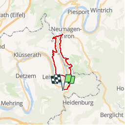
Tocht Stappen van 19,7 km beschikbaar op Rijnland-Palts, Landkreis Trier-Saarburg, Leiwen. Deze tocht wordt voorgesteld door rvapeldo.
Beschrijving
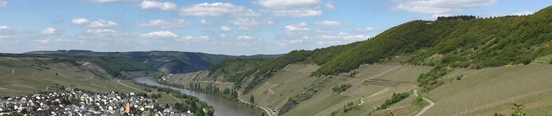
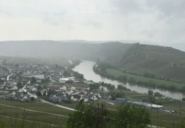
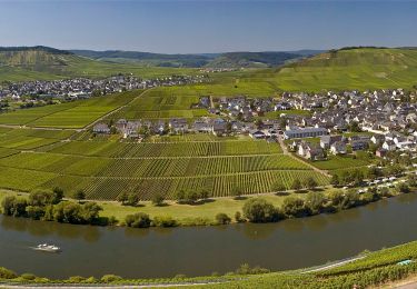
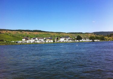
Randonnée d’une petite journée, au départ du parking situé à Zummeterhof, dans les hauteurs de Leiwin. Elle relie Neumagen pour revenir via Trittenheim,de l’autre côté de la Moselle, avant une remontée un peu raide. Très belle balade mêlant le passage dans les vignobles, avec une belle vue sur la Moselle, dans des bois avec parfois des passages un peu plus raides (avec cordes), mais pas trop difficiles. Et un passage dans le village de Neumagen, très intéressant (haut lieu de fouilles romaines), où il y a moyen de se restaurer ou d’acheter un sandwich. Puis retour de l’autre côté de la Moselle. Ce parcours mixe sans le vouloir divers sentiers (Mosselsteig, Zuweg,...).
Plaatsbepaling
Opmerkingen
Wandeltochten in de omgeving
![Tocht Te voet Leiwen - Leiwen 2 - Photo](https://media.geolcdn.com/t/375/260/48816102-5ec6-48cd-99d1-a8e2384b1bbc.jpeg&format=jpg&maxdim=2)
![Te voet Te voet](https://static1.geolcdn.com/sitytour/trail-icons/100.png)
Te voet
![](/images/other/stat-length.png)
![](https://static1.geolcdn.com/siteimages/upload/files/16400158638029165_repeat_loop_refresh_sync_direction_icon.png)
![Tocht Te voet Leiwen - Leiwen 1 - Photo](https://media.geolcdn.com/t/375/260/7a6c548d-100f-4a9a-b3a0-660df2d1b657.jpeg&format=jpg&maxdim=2)
![Te voet Te voet](https://static1.geolcdn.com/sitytour/trail-icons/100.png)
Te voet
![](/images/other/stat-length.png)
![](https://static1.geolcdn.com/siteimages/upload/files/16400158638029165_repeat_loop_refresh_sync_direction_icon.png)
![Tocht Te voet Naurath (Wald) - Naurath 1 - Photo](https://media.geolcdn.com/t/375/260/6624bca8-33ea-4807-b914-c5db2bfb203d.jpeg&format=jpg&maxdim=2)
![Te voet Te voet](https://static1.geolcdn.com/sitytour/trail-icons/100.png)
Te voet
![](/images/other/stat-length.png)
![](https://static1.geolcdn.com/siteimages/upload/files/16400158638029165_repeat_loop_refresh_sync_direction_icon.png)
![Tocht Stappen Leiwen - Leiwen hohe 6,6 km vineyards view - Photo](https://media.geolcdn.com/t/375/260/618c8dc6-aad2-483f-a964-0e57d88df197.jpg&format=jpg&maxdim=2)
![Stappen Stappen](https://static1.geolcdn.com/sitytour/trail-icons/101.png)
Stappen
![](/images/other/stat-length.png)
![](https://static1.geolcdn.com/siteimages/upload/files/16400158638029165_repeat_loop_refresh_sync_direction_icon.png)
![Tocht Stappen Leiwen - w-duitsland-mosel-leiwen - Photo](https://media.geolcdn.com/t/375/260/ext.jpg?maxdim=2&url=https%3A%2F%2Fstatic1.geolcdn.com%2Fsiteimages%2Fupload%2Ffiles%2F1553511878bg_sport_marche.png)
![Stappen Stappen](https://static1.geolcdn.com/sitytour/trail-icons/101.png)
Stappen
![](/images/other/stat-length.png)
![](https://static1.geolcdn.com/siteimages/upload/files/16400158638029165_repeat_loop_refresh_sync_direction_icon.png)
![Tocht Te voet Trittenheim - Moselachter - Photo](https://media.geolcdn.com/t/375/260/e60d06f3-60b3-4eaa-8530-ea71bef484a9.jpeg&format=jpg&maxdim=2)
![Te voet Te voet](https://static1.geolcdn.com/sitytour/trail-icons/100.png)
Te voet
![](/images/other/stat-length.png)
![](https://static1.geolcdn.com/siteimages/upload/files/16400158638029165_repeat_loop_refresh_sync_direction_icon.png)
![Tocht Te voet Pölich - Extratour Zitronenkrämerkreuz - Photo](https://media.geolcdn.com/t/375/260/4225be12-9ae6-45e1-87b5-92f1bc7029de.jpeg&format=jpg&maxdim=2)
![Te voet Te voet](https://static1.geolcdn.com/sitytour/trail-icons/100.png)
Te voet
![](/images/other/stat-length.png)
![](https://static1.geolcdn.com/siteimages/upload/files/16400158638029165_repeat_loop_refresh_sync_direction_icon.png)
![Tocht Te voet Klüsserath - Klüsserather Sagenweg - Photo](https://media.geolcdn.com/t/375/260/cbfce692-6b96-499b-a5c7-9a41ce568a69.jpeg&format=jpg&maxdim=2)
![Te voet Te voet](https://static1.geolcdn.com/sitytour/trail-icons/100.png)
Te voet
![](/images/other/stat-length.png)
![](https://static1.geolcdn.com/siteimages/upload/files/16400158638029165_repeat_loop_refresh_sync_direction_icon.png)
![Tocht Te voet Mehring - Extra Tour Mehringer Schweiz - Photo](https://media.geolcdn.com/t/375/260/c70e09d1-3329-42a6-b9cc-8ed9b21c8b80.jpeg&format=jpg&maxdim=2)
![Te voet Te voet](https://static1.geolcdn.com/sitytour/trail-icons/100.png)
Te voet
![](/images/other/stat-length.png)
![](https://static1.geolcdn.com/siteimages/upload/files/16400158638029165_repeat_loop_refresh_sync_direction_icon.png)