Tocht Hybride fiets Grenay - Autour de Lens - Photo
 PhilippeC54
PhilippeC54

Gebruiker

© OpenStreetMap contributors
Lengte
Lengte
63 km
Max. hoogte
Max. hoogte
181 m
Positief hoogteverschil
475 m
Km-Effort
Km-Effort  
69 km
Min. hoogte
Min. hoogte
13 m
Negatief hoogteverschil
477 m
Boucle
Boucle
Ja
Datum van aanmaak :
2019-04-29 07:51:10.171
Laatste wijziging :
2019-04-29 14:43:08.004

(0 Bericht)

Hybride fiets
Hybride fiets
4h56
Moeilijkheid : Heel gemakkelijk

Scan deze QR-code om de tocht te openen in de SityTrail-applicatie

Gratisgps-wandelapplicatie

Logo SityTrail SityTrail

IGN / Geografische instituten

SityTrail uit de App Store downloaden SityTrail uit Google Play downloaden

Logo SityTrail SityTrail World

De wereld gaat voor u open

SityTrail uit de App Store downloaden SityTrail uit Google Play downloaden SityTrail op Huawei AppGallery downloaden

Over ons

Tocht Hybride fiets van 63 km beschikbaar op Hauts-de-France, Pas-de-Calais, Grenay. Deze tocht wordt voorgesteld door PhilippeC54.

Hoogteprofiel

Plaatsbepaling

Land:
France
Regio :
Hauts-de-France
Departement/Provincie :
Pas-de-Calais
Gemeente :
Grenay
Locatie:
Unknown
Vertrek:(UTM)
481434 ; 5588503 (31U) N.

Wandeltochten in de omgeving

Tocht Stappen Liévin - 50 km Lievin en nocturne - Photo
Stappen
tracegps

Stappen

Zeer moeilijk
(1)
Liévin, Hauts-de-France, Pas-de-Calais, France
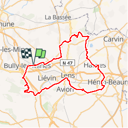
52 km | 61 km-effort
9h 0min
Ja
Tocht Stappen Angres - randonnée pinchonvalles - Photo
Stappen
Chene62

Stappen

Zeer moeilijk
Angres, Hauts-de-France, Pas-de-Calais, France
27 km | 0 m-effort
3h 24min
Neen
Tocht Andere activiteiten Liévin - boucle Liévin - Photo
Andere activiteiten
crijack

Andere activiteiten

Heel gemakkelijk
Liévin, Hauts-de-France, Pas-de-Calais, France
11 km | 12,3 km-effort
2h 2min
Ja
Tocht Andere activiteiten Liévin - boucle Liévin - Photo
Andere activiteiten
crijack

Andere activiteiten

Heel gemakkelijk
Liévin, Hauts-de-France, Pas-de-Calais, France
11 km | 12,3 km-effort
2h 2min
Ja
Tocht Lopen Aix-Noulette - aix noulette sity guide 25,3 km D530+ - Photo
Lopen
jamboxland

Lopen

Medium
Aix-Noulette, Hauts-de-France, Pas-de-Calais, France
23 km | 30 km-effort
2h 45min
Ja
Tocht Stappen Vermelles - Autour de Vermellles - Photo
Stappen
tracegps

Stappen

Moeilijk
(1)
Vermelles, Hauts-de-France, Pas-de-Calais, France
15,8 km | 16,6 km-effort
4h 0min
Ja
Tocht Stappen Noyelles-lès-Vermelles - La voie ferrée - Noyelles-lès-Vermelles - Photo
Stappen
tracegps

Stappen

Moeilijk
Noyelles-lès-Vermelles, Hauts-de-France, Pas-de-Calais, France
13,7 km | 14,6 km-effort
3h 25min
Ja
Tocht Mountainbike Angres - La randonnée VTT du Père Noël - Angres - Photo
Mountainbike
tracegps

Mountainbike

Moeilijk
(1)
Angres, Hauts-de-France, Pas-de-Calais, France
35 km | 42 km-effort
3h 0min
Ja
Tocht Stappen Aix-Noulette - Randonnée Aix Noulette - Notre Dame de Lorette - Photo
Stappen
tracegps

Stappen

Medium
Aix-Noulette, Hauts-de-France, Pas-de-Calais, France
10,6 km | 13,3 km-effort
2h 0min
Ja


Sluiten
Mijn abonnementen