![](/images/other/stat-length.png)
![Tocht Stappen Soajo - Wikiloc - Soajo - Cunhas - Cabeço da Trapela - Adrão (PNPG/ Parque Nac... - Photo](https://media.geolcdn.com/t/1900/400/f05feac8-d686-4eda-b62e-067b2b53db42.jpg&format=pjpeg&maxdim=2)
Wikiloc - Soajo - Cunhas - Cabeço da Trapela - Adrão (PNPG/ Parque Nac...
michelek
Gebruiker
![Lengte](/images/other/stat-length.png)
![Max. hoogte](https://static1.geolcdn.com/siteimages/upload/files/1508320355ic_sort_altitude_max_24dp.png)
![Positief hoogteverschil](https://static1.geolcdn.com/siteimages/upload/files/1508320355ic_sort_den_pos_24dp.png)
![Km-Effort](/images/other/stat-length.png)
![Min. hoogte](https://static1.geolcdn.com/siteimages/upload/files/1508320355ic_sort_altitude_min_24dp.png)
![Negatief hoogteverschil](https://static1.geolcdn.com/siteimages/upload/files/1508320355ic_sort_den_neg_24dp.png)
![Boucle](https://static1.geolcdn.com/siteimages/upload/files/16400158638029165_repeat_loop_refresh_sync_direction_icon.png)
![Stappen](https://static1.geolcdn.com/sitytour/trail-icons/101.png)
5h50
Moeilijkheid : Zeer moeilijk
![Scan deze QR-code om de tocht te openen in de SityTrail-applicatie](https://capi.geolives.com/qq0zvz2zws4bq2lad0pu/sitytour/trails/2068527/qr.png?size=200)
Gratisgps-wandelapplicatie
Over ons
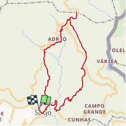
Tocht Stappen van 18,6 km beschikbaar op Norte, Viana do Castelo, Soajo. Deze tocht wordt voorgesteld door michelek.
Beschrijving
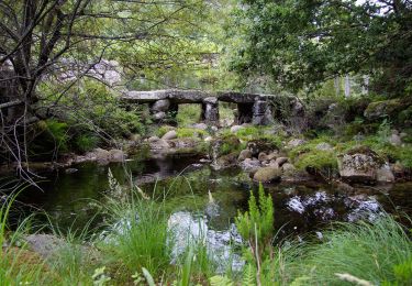
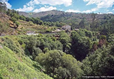
Au départ de Soajo, montée vers Adrão puis poursuivre la montée. Via la route vers Gaveira atteindre un point de vue sur toute la vallée et vers Peneda.
Retour par l'autre versant de la vallée du Rio Adrāo et retour à Soajo.
La montée jusqu'à la route vers Gaveira est bien balisée en jaune-rouge.
Plus de balisage ensuite.
Plaatsbepaling
Opmerkingen
Wandeltochten in de omgeving
![Tocht Te voet São Jorge e Ermelo - Ecovia do Ermelo - Photo](https://media.geolcdn.com/t/375/260/b03fc189-bb7f-4693-923a-e99f2c946cbf.jpeg&format=jpg&maxdim=2)
![Te voet Te voet](https://static1.geolcdn.com/sitytour/trail-icons/100.png)
Te voet
![](/images/other/stat-length.png)
![](https://static1.geolcdn.com/siteimages/upload/files/16400158638029165_repeat_loop_refresh_sync_direction_icon.png)
![Tocht Te voet Soajo - Romeiros da Peneda – Rota de Soajo (Ligação ao Mezio) - Photo](https://media.geolcdn.com/t/375/260/dd92e101-f588-4d83-818c-c174924529a5.jpeg&format=jpg&maxdim=2)
![Te voet Te voet](https://static1.geolcdn.com/sitytour/trail-icons/100.png)
Te voet
![](/images/other/stat-length.png)
![](https://static1.geolcdn.com/siteimages/upload/files/16400158638029165_repeat_loop_refresh_sync_direction_icon.png)
![Tocht Te voet Soajo - Caminhos do Pão e Caminhos da Fé (Percurso Longo) - Photo](https://media.geolcdn.com/t/375/260/cf81bae1-2829-458c-bd3c-13bf2cad7f93.jpeg&format=jpg&maxdim=2)
![Te voet Te voet](https://static1.geolcdn.com/sitytour/trail-icons/100.png)
Te voet
![](/images/other/stat-length.png)
![](https://static1.geolcdn.com/siteimages/upload/files/16400158638029165_repeat_loop_refresh_sync_direction_icon.png)
![Tocht Te voet - Trilho dos Moinhos de Parada - Photo](https://media.geolcdn.com/t/375/260/6eaa782e-40f4-4a22-a3ec-96e43151c6f3.jpeg&format=jpg&maxdim=2)
![Te voet Te voet](https://static1.geolcdn.com/sitytour/trail-icons/100.png)
Te voet
![](/images/other/stat-length.png)
![](https://static1.geolcdn.com/siteimages/upload/files/16400158638029165_repeat_loop_refresh_sync_direction_icon.png)
![Tocht Te voet Britelo - Trilho do Megalitismo de Britelo - Photo](https://media.geolcdn.com/t/375/260/e2206b2e-b34e-4da8-812b-f716f235ec18.jpeg&format=jpg&maxdim=2)
![Te voet Te voet](https://static1.geolcdn.com/sitytour/trail-icons/100.png)
Te voet
![](/images/other/stat-length.png)
![](https://static1.geolcdn.com/siteimages/upload/files/16400158638029165_repeat_loop_refresh_sync_direction_icon.png)
![Tocht Te voet Soajo - Romeiros da Peneda – Rota de Soajo - Photo](https://media.geolcdn.com/t/375/260/270c7521-c16a-423e-8a0f-e1c8e6366d43.jpeg&format=jpg&maxdim=2)
![Te voet Te voet](https://static1.geolcdn.com/sitytour/trail-icons/100.png)
Te voet
![](/images/other/stat-length.png)
![](https://static1.geolcdn.com/siteimages/upload/files/16400158638029165_repeat_loop_refresh_sync_direction_icon.png)
![Tocht Te voet Soajo - Trilho da Ribeira de Vilela - Photo](https://media.geolcdn.com/t/375/260/00592fd8-2e16-415d-af9e-21182cfbc764.jpeg&format=jpg&maxdim=2)
![Te voet Te voet](https://static1.geolcdn.com/sitytour/trail-icons/100.png)
Te voet
![](/images/other/stat-length.png)
![](https://static1.geolcdn.com/siteimages/upload/files/16400158638029165_repeat_loop_refresh_sync_direction_icon.png)
![Tocht Te voet Soajo - Trilho do Ramil - Photo](https://media.geolcdn.com/t/375/260/a0d1e248-7bed-4254-9c93-5ea466c2e602.jpeg&format=jpg&maxdim=2)
![Te voet Te voet](https://static1.geolcdn.com/sitytour/trail-icons/100.png)
Te voet
![](/images/other/stat-length.png)
![](https://static1.geolcdn.com/siteimages/upload/files/16400158638029165_repeat_loop_refresh_sync_direction_icon.png)
![Tocht Stappen Soajo - Wikiloc - Soajo - Paradela - Porco - Adrão (PNPG/ Parque Nacional da P... - Photo](https://media.geolcdn.com/t/375/260/ext.jpg?maxdim=2&url=https%3A%2F%2Fstatic1.geolcdn.com%2Fsiteimages%2Fupload%2Ffiles%2F1553511878bg_sport_marche.png)
![Stappen Stappen](https://static1.geolcdn.com/sitytour/trail-icons/101.png)
Stappen
![](/images/other/stat-length.png)
![](https://static1.geolcdn.com/siteimages/upload/files/16400158638029165_repeat_loop_refresh_sync_direction_icon.png)