![](/images/other/stat-length.png)
![Tocht Stappen Escragnolles - Escragnolles - Photo](https://media.geolcdn.com/t/1900/400/ext.pjpeg?maxdim=2&url=https%3A%2F%2Fstatic1.geolcdn.com%2Fsiteimages%2Fupload%2Ffiles%2F1553511878bg_sport_marche.png)
Escragnolles
Cagolette_lover
Gebruiker
![Lengte](/images/other/stat-length.png)
Lengte
9 km
![Max. hoogte](https://static1.geolcdn.com/siteimages/upload/files/1508320355ic_sort_altitude_max_24dp.png)
Max. hoogte
979 m
![Positief hoogteverschil](https://static1.geolcdn.com/siteimages/upload/files/1508320355ic_sort_den_pos_24dp.png)
Positief hoogteverschil
326 m
![Km-Effort](/images/other/stat-length.png)
Km-Effort
13,3 km
![Min. hoogte](https://static1.geolcdn.com/siteimages/upload/files/1508320355ic_sort_altitude_min_24dp.png)
Min. hoogte
759 m
![Negatief hoogteverschil](https://static1.geolcdn.com/siteimages/upload/files/1508320355ic_sort_den_neg_24dp.png)
Negatief hoogteverschil
328 m
![Boucle](https://static1.geolcdn.com/siteimages/upload/files/16400158638029165_repeat_loop_refresh_sync_direction_icon.png)
Boucle
Ja
Datum van aanmaak :
2019-04-18 11:40:23.652
Laatste wijziging :
2019-04-18 14:52:15.043
![Stappen](https://static1.geolcdn.com/sitytour/trail-icons/101.png)
3h08
Moeilijkheid : Heel gemakkelijk
![Scan deze QR-code om de tocht te openen in de SityTrail-applicatie](https://capi.geolives.com/qq0zvz2zws4bq2lad0pu/sitytour/trails/2063529/qr.png?size=200)
Gratisgps-wandelapplicatie
Over ons
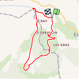
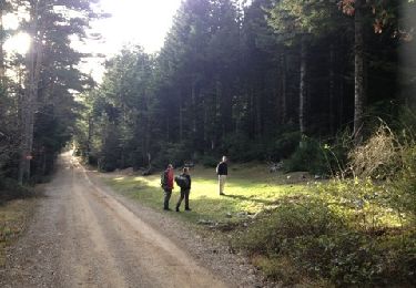
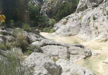
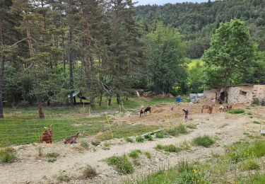
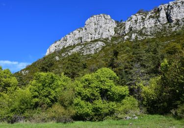
Tocht Stappen van 9 km beschikbaar op Provence-Alpes-Côte d'Azur, Alpes-Maritimes, Escragnolles. Deze tocht wordt voorgesteld door Cagolette_lover.
Beschrijving
Superbe randonnée, avec sublime cascade a voir. Rocailles, forêts, restanques et un peu de routes
Plaatsbepaling
Land:
France
Regio :
Provence-Alpes-Côte d'Azur
Departement/Provincie :
Alpes-Maritimes
Gemeente :
Escragnolles
Locatie:
Unknown
Vertrek:(Dec)
Vertrek:(UTM)
319897 ; 4845072 (32T) N.
Opmerkingen
Wandeltochten in de omgeving
![Tocht Stappen Mons - tour du Mt Lachens - Photo](https://media.geolcdn.com/t/375/260/ext.jpg?maxdim=2&url=https%3A%2F%2Fservices.sitytrail.com%2FGeolivesWS%2FDownloadMedia.ashx%3FTrailID%3D167544%26Media%3D20121228095006.jpg)
![Stappen Stappen](https://static1.geolcdn.com/sitytour/trail-icons/101.png)
tour du Mt Lachens
Stappen
Medium
(3)
Mons,
Provence-Alpes-Côte d'Azur,
Var,
France
![](/images/other/stat-length.png)
20 km | 32 km-effort
6h 53min
![](https://static1.geolcdn.com/siteimages/upload/files/16400158638029165_repeat_loop_refresh_sync_direction_icon.png)
Ja
![Tocht Stappen Escragnolles - Casade du Ray (Clars) depuis les Gallants - Photo](https://media.geolcdn.com/t/375/260/a42f38d6-7773-4eff-b635-6c5634fe1592.jpg&format=jpg&maxdim=2)
![Stappen Stappen](https://static1.geolcdn.com/sitytour/trail-icons/101.png)
Casade du Ray (Clars) depuis les Gallants
Stappen
Heel gemakkelijk
(1)
Escragnolles,
Provence-Alpes-Côte d'Azur,
Alpes-Maritimes,
France
![](/images/other/stat-length.png)
938 m | 1,3 km-effort
20min
![](https://static1.geolcdn.com/siteimages/upload/files/16400158638029165_repeat_loop_refresh_sync_direction_icon.png)
Neen
![Tocht Stappen Saint-Vallier-de-Thiey - Arche de Ponadieu Source de la Pare Baou Mourine Vieux Pont - Photo](https://media.geolcdn.com/t/375/260/7bf7c645-d759-4e3b-9f63-302e7218f005.jpg&format=jpg&maxdim=2)
![Stappen Stappen](https://static1.geolcdn.com/sitytour/trail-icons/101.png)
Arche de Ponadieu Source de la Pare Baou Mourine Vieux Pont
Stappen
Zeer moeilijk
Saint-Vallier-de-Thiey,
Provence-Alpes-Côte d'Azur,
Alpes-Maritimes,
France
![](/images/other/stat-length.png)
19,2 km | 32 km-effort
7h 20min
![](https://static1.geolcdn.com/siteimages/upload/files/16400158638029165_repeat_loop_refresh_sync_direction_icon.png)
Ja
![Tocht Stappen Saint-Vallier-de-Thiey - St Vallier de Thiey - Aqueduc de Belletrud - Arche de Ponadieu - Photo](https://media.geolcdn.com/t/375/260/102f751b-e867-453b-847f-fc313f16fe9f.jpg&format=jpg&maxdim=2)
![Stappen Stappen](https://static1.geolcdn.com/sitytour/trail-icons/101.png)
St Vallier de Thiey - Aqueduc de Belletrud - Arche de Ponadieu
Stappen
Zeer moeilijk
Saint-Vallier-de-Thiey,
Provence-Alpes-Côte d'Azur,
Alpes-Maritimes,
France
![](/images/other/stat-length.png)
18,5 km | 31 km-effort
6h 56min
![](https://static1.geolcdn.com/siteimages/upload/files/16400158638029165_repeat_loop_refresh_sync_direction_icon.png)
Ja
![Tocht Stappen Escragnolles - escragnolles mourine - Photo](https://media.geolcdn.com/t/375/260/6cf5f747-cefb-423b-ae55-31ddf95937fc.jpg&format=jpg&maxdim=2)
![Stappen Stappen](https://static1.geolcdn.com/sitytour/trail-icons/101.png)
escragnolles mourine
Stappen
Moeilijk
Escragnolles,
Provence-Alpes-Côte d'Azur,
Alpes-Maritimes,
France
![](/images/other/stat-length.png)
10,9 km | 17,7 km-effort
5h 54min
![](https://static1.geolcdn.com/siteimages/upload/files/16400158638029165_repeat_loop_refresh_sync_direction_icon.png)
Ja
![Tocht Te voet Caille - Grand tour du haut Estéron - Etape 5 - Photo](https://media.geolcdn.com/t/375/260/e0be63bf-1b07-4796-9aef-aaad8742cfa1.jpeg&format=jpg&maxdim=2)
![Te voet Te voet](https://static1.geolcdn.com/sitytour/trail-icons/100.png)
Grand tour du haut Estéron - Etape 5
Te voet
Moeilijk
Caille,
Provence-Alpes-Côte d'Azur,
Alpes-Maritimes,
France
![](/images/other/stat-length.png)
19,3 km | 32 km-effort
7h 13min
![](https://static1.geolcdn.com/siteimages/upload/files/16400158638029165_repeat_loop_refresh_sync_direction_icon.png)
Neen
![Tocht Te voet Escragnolles - Plateau de Briasq - Photo](https://media.geolcdn.com/t/375/260/3318d519-9f3b-4858-a9ae-b470b623f859.jpeg&format=jpg&maxdim=2)
![Te voet Te voet](https://static1.geolcdn.com/sitytour/trail-icons/100.png)
Plateau de Briasq
Te voet
Medium
Escragnolles,
Provence-Alpes-Côte d'Azur,
Alpes-Maritimes,
France
![](/images/other/stat-length.png)
14,1 km | 22 km-effort
4h 56min
![](https://static1.geolcdn.com/siteimages/upload/files/16400158638029165_repeat_loop_refresh_sync_direction_icon.png)
Ja
![Tocht Stappen Andon - L'Audibergue du Pont du Loup - Photo](https://media.geolcdn.com/t/375/260/461a541c-f76c-4a15-9b4e-2811bf184191.jpg&format=jpg&maxdim=2)
![Stappen Stappen](https://static1.geolcdn.com/sitytour/trail-icons/101.png)
L'Audibergue du Pont du Loup
Stappen
Gemakkelijk
Andon,
Provence-Alpes-Côte d'Azur,
Alpes-Maritimes,
France
![](/images/other/stat-length.png)
10 km | 16,2 km-effort
5h 21min
![](https://static1.geolcdn.com/siteimages/upload/files/16400158638029165_repeat_loop_refresh_sync_direction_icon.png)
Ja
![Stappen Stappen](https://static1.geolcdn.com/sitytour/trail-icons/101.png)
Andon - Pk Pont du Loup - Le Castellaras - Château des 4 Tours
Stappen
Medium
Andon,
Provence-Alpes-Côte d'Azur,
Alpes-Maritimes,
France
![](/images/other/stat-length.png)
15,6 km | 25 km-effort
5h 37min
![](https://static1.geolcdn.com/siteimages/upload/files/16400158638029165_repeat_loop_refresh_sync_direction_icon.png)
Ja