![](/images/other/stat-length.png)
![Tocht Stappen Saint-Ciers-de-Canesse - St Ciers de Canesse - Photo](https://media.geolcdn.com/t/1900/400/ext.pjpeg?maxdim=2&url=https%3A%2F%2Fstatic1.geolcdn.com%2Fsiteimages%2Fupload%2Ffiles%2F1553511878bg_sport_marche.png)
St Ciers de Canesse
JACQUOU
Gebruiker
![Lengte](/images/other/stat-length.png)
Lengte
19,4 km
![Max. hoogte](https://static1.geolcdn.com/siteimages/upload/files/1508320355ic_sort_altitude_max_24dp.png)
Max. hoogte
58 m
![Positief hoogteverschil](https://static1.geolcdn.com/siteimages/upload/files/1508320355ic_sort_den_pos_24dp.png)
Positief hoogteverschil
263 m
![Km-Effort](/images/other/stat-length.png)
Km-Effort
23 km
![Min. hoogte](https://static1.geolcdn.com/siteimages/upload/files/1508320355ic_sort_altitude_min_24dp.png)
Min. hoogte
1 m
![Negatief hoogteverschil](https://static1.geolcdn.com/siteimages/upload/files/1508320355ic_sort_den_neg_24dp.png)
Negatief hoogteverschil
263 m
![Boucle](https://static1.geolcdn.com/siteimages/upload/files/16400158638029165_repeat_loop_refresh_sync_direction_icon.png)
Boucle
Ja
Datum van aanmaak :
2019-04-08 15:33:57.541
Laatste wijziging :
2019-04-09 10:30:47.038
![Stappen](https://static1.geolcdn.com/sitytour/trail-icons/101.png)
5h00
Moeilijkheid : Zeer moeilijk
![Scan deze QR-code om de tocht te openen in de SityTrail-applicatie](https://capi.geolives.com/qq0zvz2zws4bq2lad0pu/sitytour/trails/2058861/qr.png?size=200)
Gratisgps-wandelapplicatie
Over ons
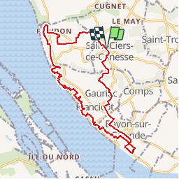
Tocht Stappen van 19,4 km beschikbaar op Nieuw-Aquitanië, Gironde, Saint-Ciers-de-Canesse. Deze tocht wordt voorgesteld door JACQUOU.
Beschrijving
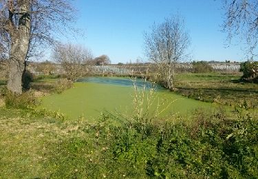
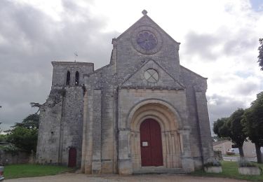
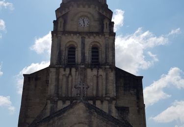
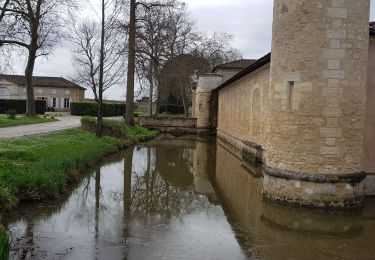
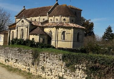
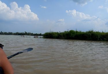
Départ de St Ciers de Canesse en passant par la Roque de Thau, l'escalier des troglodytes, le bord de l'estuaire, le château Eyquen avec la vue surl le Bec d'Ambés et retour.
Plaatsbepaling
Land:
France
Regio :
Nieuw-Aquitanië
Departement/Provincie :
Gironde
Gemeente :
Saint-Ciers-de-Canesse
Locatie:
Unknown
Vertrek:(Dec)
Vertrek:(UTM)
688087 ; 4995034 (30T) N.
Opmerkingen
Wandeltochten in de omgeving
![Tocht Stappen Gauriac - Corniche de Gironde - Photo](https://media.geolcdn.com/t/375/260/ext.jpg?maxdim=2&url=https%3A%2F%2Fservices.sitytrail.com%2FGeolivesWS%2FDownloadMedia.ashx%3FTrailID%3D271558%26Media%3Dfix__20140309161312.jpg)
![Stappen Stappen](https://static1.geolcdn.com/sitytour/trail-icons/101.png)
Corniche de Gironde
Stappen
Medium
(3)
Gauriac,
Nieuw-Aquitanië,
Gironde,
France
![](/images/other/stat-length.png)
14,1 km | 16,8 km-effort
3h 15min
![](https://static1.geolcdn.com/siteimages/upload/files/16400158638029165_repeat_loop_refresh_sync_direction_icon.png)
Ja
![Tocht Te voet Villeneuve - Balade de l'Estuaire - Photo](https://media.geolcdn.com/t/375/260/70ced56f-ce74-4a0d-8474-be54a1713be3.jpeg&format=jpg&maxdim=2)
![Te voet Te voet](https://static1.geolcdn.com/sitytour/trail-icons/100.png)
Balade de l'Estuaire
Te voet
Gemakkelijk
Villeneuve,
Nieuw-Aquitanië,
Gironde,
France
![](/images/other/stat-length.png)
13,2 km | 15,8 km-effort
3h 35min
![](https://static1.geolcdn.com/siteimages/upload/files/16400158638029165_repeat_loop_refresh_sync_direction_icon.png)
Ja
![Tocht Stappen Bayon-sur-Gironde - Bayon ses vignes et la Gironde - Photo](https://media.geolcdn.com/t/375/260/17337f03-d723-4bb3-bf19-fe5875f8d73d.jpg&format=jpg&maxdim=2)
![Stappen Stappen](https://static1.geolcdn.com/sitytour/trail-icons/101.png)
Bayon ses vignes et la Gironde
Stappen
Heel gemakkelijk
Bayon-sur-Gironde,
Nieuw-Aquitanië,
Gironde,
France
![](/images/other/stat-length.png)
3,6 km | 4,2 km-effort
55min
![](https://static1.geolcdn.com/siteimages/upload/files/16400158638029165_repeat_loop_refresh_sync_direction_icon.png)
Ja
![Tocht Stappen Margaux-Cantenac - Margaux - Photo](https://media.geolcdn.com/t/375/260/ca4cf701-6f06-49a0-b9b1-efb58a53d587.jpg&format=jpg&maxdim=2)
![Stappen Stappen](https://static1.geolcdn.com/sitytour/trail-icons/101.png)
Margaux
Stappen
Gemakkelijk
Margaux-Cantenac,
Nieuw-Aquitanië,
Gironde,
France
![](/images/other/stat-length.png)
11,4 km | 12,2 km-effort
2h 23min
![](https://static1.geolcdn.com/siteimages/upload/files/16400158638029165_repeat_loop_refresh_sync_direction_icon.png)
Ja
![Tocht Stappen Gauriac - Le nord de l'estuaire - Photo](https://media.geolcdn.com/t/375/260/ext.jpg?maxdim=2&url=https%3A%2F%2Fservices.sitytrail.com%2FGeolivesWS%2FDownloadMedia.ashx%3FTrailID%3D711959%26Media%3Dfix__20170311123621.jpg)
![Stappen Stappen](https://static1.geolcdn.com/sitytour/trail-icons/101.png)
Le nord de l'estuaire
Stappen
Medium
Gauriac,
Nieuw-Aquitanië,
Gironde,
France
![](/images/other/stat-length.png)
14,8 km | 17,9 km-effort
2h 52min
![](https://static1.geolcdn.com/siteimages/upload/files/16400158638029165_repeat_loop_refresh_sync_direction_icon.png)
Ja
![Tocht Andere activiteiten Margaux-Cantenac - Blaye en kayak - Photo](https://media.geolcdn.com/t/375/260/ext.jpg?maxdim=2&url=https%3A%2F%2Fservices.sitytrail.com%2FGeolivesWS%2FDownloadMedia.ashx%3FTrailID%3D327412%26Media%3Dfix__20140724174919.jpg)
![Andere activiteiten Andere activiteiten](https://static1.geolcdn.com/sitytour/trail-icons/900.png)
Blaye en kayak
Andere activiteiten
Medium
Margaux-Cantenac,
Nieuw-Aquitanië,
Gironde,
France
![](/images/other/stat-length.png)
32 km | 33 km-effort
5h 9min
![](https://static1.geolcdn.com/siteimages/upload/files/16400158638029165_repeat_loop_refresh_sync_direction_icon.png)
Ja
![Tocht Stappen Mombrier - 20/10/24 - Photo](https://media.geolcdn.com/t/375/260/ext.jpg?maxdim=2&url=https%3A%2F%2Fstatic1.geolcdn.com%2Fsiteimages%2Fupload%2Ffiles%2F1553511878bg_sport_marche.png)
![Stappen Stappen](https://static1.geolcdn.com/sitytour/trail-icons/101.png)
![Tocht Stappen Bourg - Boucle de la Libarde - Photo](https://media.geolcdn.com/t/375/260/ext.jpg?maxdim=2&url=https%3A%2F%2Fstatic1.geolcdn.com%2Fsiteimages%2Fupload%2Ffiles%2F1553511878bg_sport_marche.png)
![Stappen Stappen](https://static1.geolcdn.com/sitytour/trail-icons/101.png)
Boucle de la Libarde
Stappen
Medium
Bourg,
Nieuw-Aquitanië,
Gironde,
France
![](/images/other/stat-length.png)
9,8 km | 12,1 km-effort
2h 44min
![](https://static1.geolcdn.com/siteimages/upload/files/16400158638029165_repeat_loop_refresh_sync_direction_icon.png)
Ja
![Tocht Stappen Bourg - Bourg flânerie - Photo](https://media.geolcdn.com/t/375/260/ext.jpg?maxdim=2&url=https%3A%2F%2Fstatic1.geolcdn.com%2Fsiteimages%2Fupload%2Ffiles%2F1553511878bg_sport_marche.png)
![Stappen Stappen](https://static1.geolcdn.com/sitytour/trail-icons/101.png)
Bourg flânerie
Stappen
Gemakkelijk
Bourg,
Nieuw-Aquitanië,
Gironde,
France
![](/images/other/stat-length.png)
5,4 km | 6,4 km-effort
1h 34min
![](https://static1.geolcdn.com/siteimages/upload/files/16400158638029165_repeat_loop_refresh_sync_direction_icon.png)
Ja