![](/images/other/stat-length.png)
![Tocht Stappen Beyne-Heusay - Bellaire _ Marche Fédéral _ Salle - Havart _ Rue Vieux Trier _ 4610 BELLAIRE - Photo](https://media.geolcdn.com/t/1900/400/1393e1f7-3aa1-42d5-9e07-5cb6877af0ac.jpg&format=pjpeg&maxdim=2)
Bellaire _ Marche Fédéral _ Salle - Havart _ Rue Vieux Trier _ 4610 BELLAIRE
jeangulu
Gebruiker
![Lengte](/images/other/stat-length.png)
Lengte
18,9 km
![Max. hoogte](https://static1.geolcdn.com/siteimages/upload/files/1508320355ic_sort_altitude_max_24dp.png)
Max. hoogte
281 m
![Positief hoogteverschil](https://static1.geolcdn.com/siteimages/upload/files/1508320355ic_sort_den_pos_24dp.png)
Positief hoogteverschil
358 m
![Km-Effort](/images/other/stat-length.png)
Km-Effort
24 km
![Min. hoogte](https://static1.geolcdn.com/siteimages/upload/files/1508320355ic_sort_altitude_min_24dp.png)
Min. hoogte
89 m
![Negatief hoogteverschil](https://static1.geolcdn.com/siteimages/upload/files/1508320355ic_sort_den_neg_24dp.png)
Negatief hoogteverschil
357 m
![Boucle](https://static1.geolcdn.com/siteimages/upload/files/16400158638029165_repeat_loop_refresh_sync_direction_icon.png)
Boucle
Ja
Datum van aanmaak :
2019-04-06 08:12:57.606
Laatste wijziging :
2019-04-06 13:08:54.06
![Stappen](https://static1.geolcdn.com/sitytour/trail-icons/101.png)
4h54
Moeilijkheid : Gemakkelijk
![Scan deze QR-code om de tocht te openen in de SityTrail-applicatie](https://capi.geolives.com/qq0zvz2zws4bq2lad0pu/sitytour/trails/2057647/qr.png?size=200)
Gratisgps-wandelapplicatie
Over ons
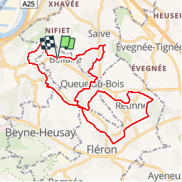
Tocht Stappen van 18,9 km beschikbaar op Wallonië, Luik, Beyne-Heusay. Deze tocht wordt voorgesteld door jeangulu.
Beschrijving
45ème Marche des Pingouins beau parcours dommage beaucoup de routes sur une grande partie du parcours quelques sentiers et quelques bois
Plaatsbepaling
Land:
Belgium
Regio :
Wallonië
Departement/Provincie :
Luik
Gemeente :
Beyne-Heusay
Locatie:
Bellaire
Vertrek:(Dec)
Vertrek:(UTM)
688212 ; 5613685 (31U) N.
Opmerkingen
Wandeltochten in de omgeving
![Tocht Stappen Fléron - 2024-06-16_18h18m53_1402.gpx.xml - Photo](https://media.geolcdn.com/t/375/260/65875cd7-f353-4090-b6ef-a8656311fae6.jpg&format=jpg&maxdim=2)
![Stappen Stappen](https://static1.geolcdn.com/sitytour/trail-icons/101.png)
2024-06-16_18h18m53_1402.gpx.xml
Stappen
Medium
(1)
Fléron,
Wallonië,
Luik,
Belgium
![](/images/other/stat-length.png)
9,8 km | 12,3 km-effort
2h 47min
![](https://static1.geolcdn.com/siteimages/upload/files/16400158638029165_repeat_loop_refresh_sync_direction_icon.png)
Ja
![Tocht Stappen Blegny - 2023-07-28_14h00m33_1702.gpx.xml - Photo](https://media.geolcdn.com/t/375/260/08e717c2-a47c-47f0-9a4e-fb7b564b3f18.jpg&format=jpg&maxdim=2)
![Stappen Stappen](https://static1.geolcdn.com/sitytour/trail-icons/101.png)
2023-07-28_14h00m33_1702.gpx.xml
Stappen
Gemakkelijk
(1)
Blegny,
Wallonië,
Luik,
Belgium
![](/images/other/stat-length.png)
9,9 km | 11,8 km-effort
2h 40min
![](https://static1.geolcdn.com/siteimages/upload/files/16400158638029165_repeat_loop_refresh_sync_direction_icon.png)
Ja
![Tocht Stappen Blegny - 20230703 - Blegny-Mine 6.8 Km - Photo](https://media.geolcdn.com/t/375/260/840a4c96-62cb-4388-9c6c-d720f9bd1cc9.jpeg&format=jpg&maxdim=2)
![Stappen Stappen](https://static1.geolcdn.com/sitytour/trail-icons/101.png)
20230703 - Blegny-Mine 6.8 Km
Stappen
Medium
(1)
Blegny,
Wallonië,
Luik,
Belgium
![](/images/other/stat-length.png)
6,8 km | 8,6 km-effort
2h 8min
![](https://static1.geolcdn.com/siteimages/upload/files/16400158638029165_repeat_loop_refresh_sync_direction_icon.png)
Ja
![Tocht Stappen Soumagne - 2021-10-28_12h59m26_1395 - Photo](https://media.geolcdn.com/t/375/260/a90bb153-f7f9-4ccc-abe3-d0c8ad0a64f0.jpg&format=jpg&maxdim=2)
![Stappen Stappen](https://static1.geolcdn.com/sitytour/trail-icons/101.png)
2021-10-28_12h59m26_1395
Stappen
Gemakkelijk
(3)
Soumagne,
Wallonië,
Luik,
Belgium
![](/images/other/stat-length.png)
10,4 km | 13,4 km-effort
3h 2min
![](https://static1.geolcdn.com/siteimages/upload/files/16400158638029165_repeat_loop_refresh_sync_direction_icon.png)
Ja
![Tocht Stappen Luik - GG-Lg-10_Angleur - Nessonvaux - Photo](https://media.geolcdn.com/t/375/260/04d5e1fb-7fbe-4c80-8636-73a8d0ed7b0e.jpg&format=jpg&maxdim=2)
![Stappen Stappen](https://static1.geolcdn.com/sitytour/trail-icons/101.png)
GG-Lg-10_Angleur - Nessonvaux
Stappen
Zeer moeilijk
(2)
Luik,
Wallonië,
Luik,
Belgium
![](/images/other/stat-length.png)
22 km | 32 km-effort
6h 27min
![](https://static1.geolcdn.com/siteimages/upload/files/16400158638029165_repeat_loop_refresh_sync_direction_icon.png)
Neen
![Tocht Stappen Luik - 2021-03-07_15h45m11_1615128300605_UnnMrtGYyrs - Photo](https://media.geolcdn.com/t/375/260/1db82134-c6f1-4cf9-9ec5-4781d8a78844.jpg&format=jpg&maxdim=2)
![Stappen Stappen](https://static1.geolcdn.com/sitytour/trail-icons/101.png)
2021-03-07_15h45m11_1615128300605_UnnMrtGYyrs
Stappen
Gemakkelijk
(1)
Luik,
Wallonië,
Luik,
Belgium
![](/images/other/stat-length.png)
3 km | 3,9 km-effort
53min
![](https://static1.geolcdn.com/siteimages/upload/files/16400158638029165_repeat_loop_refresh_sync_direction_icon.png)
Ja
![Tocht Stappen Fléron - F15 Fléron Fond du Pucet - Photo](https://media.geolcdn.com/t/375/260/52059866-a3d8-42bb-ace6-902ab69a25c9.jpg&format=jpg&maxdim=2)
![Stappen Stappen](https://static1.geolcdn.com/sitytour/trail-icons/101.png)
F15 Fléron Fond du Pucet
Stappen
Gemakkelijk
(2)
Fléron,
Wallonië,
Luik,
Belgium
![](/images/other/stat-length.png)
4,8 km | 6 km-effort
57min
![](https://static1.geolcdn.com/siteimages/upload/files/16400158638029165_repeat_loop_refresh_sync_direction_icon.png)
Ja
![Tocht Stappen Chaudfontaine - A la découverte des Thermes et Coteaux: La Chapelle St Anne - Photo](https://media.geolcdn.com/t/375/260/6a396cf7-4042-42d2-b979-a2139ec4e634.jpg&format=jpg&maxdim=2)
![Stappen Stappen](https://static1.geolcdn.com/sitytour/trail-icons/101.png)
A la découverte des Thermes et Coteaux: La Chapelle St Anne
Stappen
Medium
(1)
Chaudfontaine,
Wallonië,
Luik,
Belgium
![](/images/other/stat-length.png)
7,2 km | 10,4 km-effort
2h 12min
![](https://static1.geolcdn.com/siteimages/upload/files/16400158638029165_repeat_loop_refresh_sync_direction_icon.png)
Ja
![Tocht Elektrische fiets Blegny - Par les Houlpais - Photo](https://media.geolcdn.com/t/375/260/91501caf-acdf-43bf-a952-638e9aed87aa.jpg&format=jpg&maxdim=2)
![Elektrische fiets Elektrische fiets](https://static1.geolcdn.com/sitytour/trail-icons/205.png)
Par les Houlpais
Elektrische fiets
Moeilijk
(1)
Blegny,
Wallonië,
Luik,
Belgium
![](/images/other/stat-length.png)
37 km | 48 km-effort
2h 30min
![](https://static1.geolcdn.com/siteimages/upload/files/16400158638029165_repeat_loop_refresh_sync_direction_icon.png)
Ja