![](/images/other/stat-length.png)
![Tocht Wegfiets Calvià - Jour 2 - 98km - Photo](https://media.geolcdn.com/t/1900/400/ext.pjpeg?maxdim=2&url=https%3A%2F%2Fstatic1.geolcdn.com%2Fsiteimages%2Fupload%2Ffiles%2F1524743154velo.jpg)
Jour 2 - 98km
bobby1
Gebruiker
![Lengte](/images/other/stat-length.png)
Lengte
98 km
![Max. hoogte](https://static1.geolcdn.com/siteimages/upload/files/1508320355ic_sort_altitude_max_24dp.png)
Max. hoogte
508 m
![Positief hoogteverschil](https://static1.geolcdn.com/siteimages/upload/files/1508320355ic_sort_den_pos_24dp.png)
Positief hoogteverschil
2210 m
![Km-Effort](/images/other/stat-length.png)
Km-Effort
128 km
![Min. hoogte](https://static1.geolcdn.com/siteimages/upload/files/1508320355ic_sort_altitude_min_24dp.png)
Min. hoogte
7 m
![Negatief hoogteverschil](https://static1.geolcdn.com/siteimages/upload/files/1508320355ic_sort_den_neg_24dp.png)
Negatief hoogteverschil
2210 m
![Boucle](https://static1.geolcdn.com/siteimages/upload/files/16400158638029165_repeat_loop_refresh_sync_direction_icon.png)
Boucle
Ja
Datum van aanmaak :
2019-03-25 20:58:58.574
Laatste wijziging :
2019-03-25 21:01:29.17
![Wegfiets](https://static1.geolcdn.com/sitytour/trail-icons/201.png)
7h18
Moeilijkheid : Zeer moeilijk
![Scan deze QR-code om de tocht te openen in de SityTrail-applicatie](https://capi.geolives.com/qq0zvz2zws4bq2lad0pu/sitytour/trails/2052610/qr.png?size=200)
Gratisgps-wandelapplicatie
Over ons
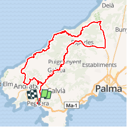
Tocht Wegfiets van 98 km beschikbaar op Balearen, Onbekend, Calvià. Deze tocht wordt voorgesteld door bobby1.
Beschrijving
Peguera - Es Capdella - Andratx - Estellencs - Banyalbufar - Valldemosssa - Esgleieta - Esporles - Puigpunyent - Galilea - Es Capdella - Peguera
Plaatsbepaling
Land:
Spain
Regio :
Balearen
Departement/Provincie :
Onbekend
Gemeente :
Calvià
Locatie:
Unknown
Vertrek:(Dec)
Vertrek:(UTM)
453537 ; 4376164 (31S) N.
Opmerkingen
Wandeltochten in de omgeving
![Tocht Te voet Calvià - ES-This has not official name. It seems it has german unofficial name. Please, note that the hiking routes have no name if not appear in official sources (Consell de Mallorca, Comunitat Autònoma de les Illes Balears, Townhall publications, etc) - Photo](https://media.geolcdn.com/t/375/260/e790b3da-512c-4682-a0e9-5527d7d0b775.jpeg&format=jpg&maxdim=2)
![Te voet Te voet](https://static1.geolcdn.com/sitytour/trail-icons/100.png)
ES-This has not official name. It seems it has german unofficial name. Please...
Te voet
Gemakkelijk
Calvià,
Balearen,
Onbekend,
Spain
![](/images/other/stat-length.png)
3,7 km | 4,7 km-effort
1h 4min
![](https://static1.geolcdn.com/siteimages/upload/files/16400158638029165_repeat_loop_refresh_sync_direction_icon.png)
Neen
![Tocht sport Calvià - Cap d’andritxol - Photo](https://media.geolcdn.com/t/375/260/26ada991-bf8c-4338-bbf8-83ce755ec14e.jpg&format=jpg&maxdim=2)
Cap d’andritxol
sport
Heel gemakkelijk
Calvià,
Balearen,
Onbekend,
Spain
![](/images/other/stat-length.png)
7,1 km | 10,1 km-effort
Onbekend
![](https://static1.geolcdn.com/siteimages/upload/files/16400158638029165_repeat_loop_refresh_sync_direction_icon.png)
Ja
![Tocht Te voet Calvià - Nachtigallental - Photo](https://media.geolcdn.com/t/375/260/ext.jpg?maxdim=2&url=https%3A%2F%2Fstatic1.geolcdn.com%2Fsiteimages%2Fupload%2Ffiles%2F1545311037marcheuse_200dpi.jpg)
![Te voet Te voet](https://static1.geolcdn.com/sitytour/trail-icons/100.png)
Nachtigallental
Te voet
Gemakkelijk
Calvià,
Balearen,
Onbekend,
Spain
![](/images/other/stat-length.png)
5,6 km | 7,2 km-effort
1h 37min
![](https://static1.geolcdn.com/siteimages/upload/files/16400158638029165_repeat_loop_refresh_sync_direction_icon.png)
Neen
![Tocht Wegfiets Calvià - Jour 3 - 120km - Photo](https://media.geolcdn.com/t/375/260/ext.jpg?maxdim=2&url=https%3A%2F%2Fstatic1.geolcdn.com%2Fsiteimages%2Fupload%2Ffiles%2F1524743154velo.jpg)
![Wegfiets Wegfiets](https://static1.geolcdn.com/sitytour/trail-icons/201.png)
Jour 3 - 120km
Wegfiets
Zeer moeilijk
Calvià,
Balearen,
Onbekend,
Spain
![](/images/other/stat-length.png)
118 km | 145 km-effort
8h 22min
![](https://static1.geolcdn.com/siteimages/upload/files/16400158638029165_repeat_loop_refresh_sync_direction_icon.png)
Ja
![Tocht Stappen Calvià - Mallorca-Cap Andritxol 18-10-2017 - Photo](https://media.geolcdn.com/t/375/260/ext.jpg?maxdim=2&url=https%3A%2F%2Fstatic1.geolcdn.com%2Fsiteimages%2Fupload%2Ffiles%2F1553511878bg_sport_marche.png)
![Stappen Stappen](https://static1.geolcdn.com/sitytour/trail-icons/101.png)
Mallorca-Cap Andritxol 18-10-2017
Stappen
Gemakkelijk
Calvià,
Balearen,
Onbekend,
Spain
![](/images/other/stat-length.png)
8,7 km | 12,2 km-effort
2h 32min
![](https://static1.geolcdn.com/siteimages/upload/files/16400158638029165_repeat_loop_refresh_sync_direction_icon.png)
Ja
![Tocht Stappen Calvià - Mallorca-Sa Bruta 18-10-2017 - Photo](https://media.geolcdn.com/t/375/260/ext.jpg?maxdim=2&url=https%3A%2F%2Fstatic1.geolcdn.com%2Fsiteimages%2Fupload%2Ffiles%2F1553511878bg_sport_marche.png)
![Stappen Stappen](https://static1.geolcdn.com/sitytour/trail-icons/101.png)
Mallorca-Sa Bruta 18-10-2017
Stappen
Gemakkelijk
Calvià,
Balearen,
Onbekend,
Spain
![](/images/other/stat-length.png)
6,5 km | 10 km-effort
2h 13min
![](https://static1.geolcdn.com/siteimages/upload/files/16400158638029165_repeat_loop_refresh_sync_direction_icon.png)
Ja
![Tocht Fiets Andratx - andtrax_to_pollenca_8_cols_154k_3000m - Photo](https://media.geolcdn.com/t/375/260/ext.jpg?maxdim=2&url=https%3A%2F%2Fstatic1.geolcdn.com%2Fsiteimages%2Fupload%2Ffiles%2F1524743154velo.jpg)
![Fiets Fiets](https://static1.geolcdn.com/sitytour/trail-icons/200.png)
andtrax_to_pollenca_8_cols_154k_3000m
Fiets
Zeer moeilijk
Andratx,
Balearen,
Onbekend,
Spain
![](/images/other/stat-length.png)
154 km | 197 km-effort
Onbekend
![](https://static1.geolcdn.com/siteimages/upload/files/16400158638029165_repeat_loop_refresh_sync_direction_icon.png)
Neen
![Tocht Fiets Andratx - andratx_to_pollenca_ma10_116k_2500m - Photo](https://media.geolcdn.com/t/375/260/ext.jpg?maxdim=2&url=https%3A%2F%2Fstatic1.geolcdn.com%2Fsiteimages%2Fupload%2Ffiles%2F1524743154velo.jpg)
![Fiets Fiets](https://static1.geolcdn.com/sitytour/trail-icons/200.png)
andratx_to_pollenca_ma10_116k_2500m
Fiets
Moeilijk
Andratx,
Balearen,
Onbekend,
Spain
![](/images/other/stat-length.png)
116 km | 156 km-effort
Onbekend
![](https://static1.geolcdn.com/siteimages/upload/files/16400158638029165_repeat_loop_refresh_sync_direction_icon.png)
Neen
![Tocht Fiets Andratx - andtrax_to_pollenca_139k_2600m - Photo](https://media.geolcdn.com/t/375/260/ext.jpg?maxdim=2&url=https%3A%2F%2Fstatic1.geolcdn.com%2Fsiteimages%2Fupload%2Ffiles%2F1524743154velo.jpg)
![Fiets Fiets](https://static1.geolcdn.com/sitytour/trail-icons/200.png)
andtrax_to_pollenca_139k_2600m
Fiets
Moeilijk
Andratx,
Balearen,
Onbekend,
Spain
![](/images/other/stat-length.png)
139 km | 177 km-effort
Onbekend
![](https://static1.geolcdn.com/siteimages/upload/files/16400158638029165_repeat_loop_refresh_sync_direction_icon.png)
Neen