![](/images/other/stat-length.png)
![Tocht Te voet Neuilly-sur-Marne - 9657444-Neuilly Champs sm L93 2 - Photo](https://media.geolcdn.com/t/1900/400/ext.pjpeg?maxdim=2&url=https%3A%2F%2Fstatic1.geolcdn.com%2Fsiteimages%2Fupload%2Ffiles%2F1545311037marcheuse_200dpi.jpg)
9657444-Neuilly Champs sm L93 2
jctinchebray
Gebruiker
![Lengte](/images/other/stat-length.png)
Lengte
13 km
![Max. hoogte](https://static1.geolcdn.com/siteimages/upload/files/1508320355ic_sort_altitude_max_24dp.png)
Max. hoogte
45 m
![Positief hoogteverschil](https://static1.geolcdn.com/siteimages/upload/files/1508320355ic_sort_den_pos_24dp.png)
Positief hoogteverschil
62 m
![Km-Effort](/images/other/stat-length.png)
Km-Effort
13,8 km
![Min. hoogte](https://static1.geolcdn.com/siteimages/upload/files/1508320355ic_sort_altitude_min_24dp.png)
Min. hoogte
34 m
![Negatief hoogteverschil](https://static1.geolcdn.com/siteimages/upload/files/1508320355ic_sort_den_neg_24dp.png)
Negatief hoogteverschil
62 m
![Boucle](https://static1.geolcdn.com/siteimages/upload/files/16400158638029165_repeat_loop_refresh_sync_direction_icon.png)
Boucle
Ja
Datum van aanmaak :
2019-03-23 09:26:44.787
Laatste wijziging :
2019-04-20 15:12:39.666
![Te voet](https://static1.geolcdn.com/sitytour/trail-icons/100.png)
--
Moeilijkheid : Gemakkelijk
![Scan deze QR-code om de tocht te openen in de SityTrail-applicatie](https://capi.geolives.com/qq0zvz2zws4bq2lad0pu/sitytour/trails/2050991/qr.png?size=200)
Gratisgps-wandelapplicatie
Over ons
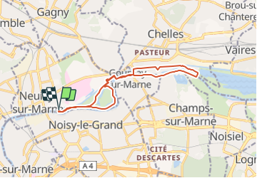
Tocht Te voet van 13 km beschikbaar op Île-de-France, Seine-Saint-Denis, Neuilly-sur-Marne. Deze tocht wordt voorgesteld door jctinchebray.
Beschrijving
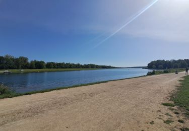
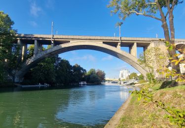
Randonnée boucle de 13km au départ de l'écluse de Neuilly sur marne et passant par la haute ile, les bords de marne et le canal.
Plaatsbepaling
Land:
France
Regio :
Île-de-France
Departement/Provincie :
Seine-Saint-Denis
Gemeente :
Neuilly-sur-Marne
Locatie:
Unknown
Vertrek:(Dec)
Vertrek:(UTM)
466206 ; 5411334 (31U) N.
Opmerkingen
Wandeltochten in de omgeving
![Tocht Stappen Neuilly-Plaisance - Neuilly Plaisance gare Rer sortie Bords de Marne/ Base Nautique Vaires sur Marne - Photo](https://media.geolcdn.com/t/375/260/3fb9e5a2-0030-4f1a-a960-e880d0c7625d.jpg&format=jpg&maxdim=2)
![Stappen Stappen](https://static1.geolcdn.com/sitytour/trail-icons/101.png)
Neuilly Plaisance gare Rer sortie Bords de Marne/ Base Nautique Vaires sur Marne
Stappen
Gemakkelijk
(1)
Neuilly-Plaisance,
Île-de-France,
Seine-Saint-Denis,
France
![](/images/other/stat-length.png)
15,9 km | 17,1 km-effort
2h 52min
![](https://static1.geolcdn.com/siteimages/upload/files/16400158638029165_repeat_loop_refresh_sync_direction_icon.png)
Ja
![Tocht Stappen Chelles - GRP CV-IDF 06 - Photo](https://media.geolcdn.com/t/375/260/3e851a57-05bf-470c-9490-37cd07bf40e9.jpg&format=jpg&maxdim=2)
![Stappen Stappen](https://static1.geolcdn.com/sitytour/trail-icons/101.png)
GRP CV-IDF 06
Stappen
Medium
(1)
Chelles,
Île-de-France,
Seine-et-Marne,
France
![](/images/other/stat-length.png)
15 km | 16,7 km-effort
3h 47min
![](https://static1.geolcdn.com/siteimages/upload/files/16400158638029165_repeat_loop_refresh_sync_direction_icon.png)
Neen
![Tocht Stappen Champs-sur-Marne - Boucle 20 km autour de Champs sur Marne - Photo](https://media.geolcdn.com/t/375/260/e5bc49c5-8534-4b14-8b85-21b9437dca8c.jpg&format=jpg&maxdim=2)
![Stappen Stappen](https://static1.geolcdn.com/sitytour/trail-icons/101.png)
Boucle 20 km autour de Champs sur Marne
Stappen
Gemakkelijk
Champs-sur-Marne,
Île-de-France,
Seine-et-Marne,
France
![](/images/other/stat-length.png)
19,8 km | 22 km-effort
4h 29min
![](https://static1.geolcdn.com/siteimages/upload/files/16400158638029165_repeat_loop_refresh_sync_direction_icon.png)
Ja
![Tocht Te voet Champigny-sur-Marne - Sur les bords de Marne - Photo](https://media.geolcdn.com/t/375/260/0848a8c4-6d65-4224-9dca-3686da6f2272.jpg&format=jpg&maxdim=2)
![Te voet Te voet](https://static1.geolcdn.com/sitytour/trail-icons/100.png)
Sur les bords de Marne
Te voet
Medium
Champigny-sur-Marne,
Île-de-France,
Val-de-Marne,
France
![](/images/other/stat-length.png)
32 km | 35 km-effort
7h 52min
![](https://static1.geolcdn.com/siteimages/upload/files/16400158638029165_repeat_loop_refresh_sync_direction_icon.png)
Ja
![Tocht Stappen Saint-Maur-des-Fossés - Boucle St Maur - Vincennes - Photo](https://media.geolcdn.com/t/375/260/07d4e882-57e1-4d05-a0e2-c5807ef2ec4c.jpg&format=jpg&maxdim=2)
![Stappen Stappen](https://static1.geolcdn.com/sitytour/trail-icons/101.png)
Boucle St Maur - Vincennes
Stappen
Saint-Maur-des-Fossés,
Île-de-France,
Val-de-Marne,
France
![](/images/other/stat-length.png)
22 km | 24 km-effort
5h 32min
![](https://static1.geolcdn.com/siteimages/upload/files/16400158638029165_repeat_loop_refresh_sync_direction_icon.png)
Ja
![Tocht Stappen Gournay-sur-Marne - Boucle Gournay/ Marne - Noisy le Grand - Champs sur Marne - Photo](https://media.geolcdn.com/t/375/260/89921577-96fb-496f-92ce-fb28ab23f5a4.jpg&format=jpg&maxdim=2)
![Stappen Stappen](https://static1.geolcdn.com/sitytour/trail-icons/101.png)
Boucle Gournay/ Marne - Noisy le Grand - Champs sur Marne
Stappen
Heel gemakkelijk
Gournay-sur-Marne,
Île-de-France,
Seine-Saint-Denis,
France
![](/images/other/stat-length.png)
20 km | 23 km-effort
4h 41min
![](https://static1.geolcdn.com/siteimages/upload/files/16400158638029165_repeat_loop_refresh_sync_direction_icon.png)
Ja
![Tocht Mountainbike Fontenay-sous-Bois - vtt bois de vincennes - Photo](https://media.geolcdn.com/t/375/260/ext.jpg?maxdim=2&url=https%3A%2F%2Fstatic1.geolcdn.com%2Fsiteimages%2Fupload%2Ffiles%2F1524743154velo.jpg)
![Mountainbike Mountainbike](https://static1.geolcdn.com/sitytour/trail-icons/202.png)
vtt bois de vincennes
Mountainbike
Medium
(1)
Fontenay-sous-Bois,
Île-de-France,
Val-de-Marne,
France
![](/images/other/stat-length.png)
38 km | 42 km-effort
1h 59min
![](https://static1.geolcdn.com/siteimages/upload/files/16400158638029165_repeat_loop_refresh_sync_direction_icon.png)
Ja
![Tocht Stappen Champigny-sur-Marne - BM Bord de Marne : Nogent-Gournay AR 21km - Photo](https://media.geolcdn.com/t/375/260/d8a7ca9d-36a1-43a8-b0ad-da38a2a2adfc.jpg&format=jpg&maxdim=2)
![Stappen Stappen](https://static1.geolcdn.com/sitytour/trail-icons/101.png)
BM Bord de Marne : Nogent-Gournay AR 21km
Stappen
Zeer moeilijk
Champigny-sur-Marne,
Île-de-France,
Val-de-Marne,
France
![](/images/other/stat-length.png)
21 km | 23 km-effort
5h 10min
![](https://static1.geolcdn.com/siteimages/upload/files/16400158638029165_repeat_loop_refresh_sync_direction_icon.png)
Ja
![Tocht Stappen Nogent-sur-Marne - 2023 06 25 - Photo](https://media.geolcdn.com/t/375/260/5e8f4917-23cc-40cc-a8e3-6d600f9f06b3.jpg&format=jpg&maxdim=2)
![Stappen Stappen](https://static1.geolcdn.com/sitytour/trail-icons/101.png)
2023 06 25
Stappen
Zeer moeilijk
Nogent-sur-Marne,
Île-de-France,
Val-de-Marne,
France
![](/images/other/stat-length.png)
17,4 km | 19,3 km-effort
3h 45min
![](https://static1.geolcdn.com/siteimages/upload/files/16400158638029165_repeat_loop_refresh_sync_direction_icon.png)
Ja