![](/images/other/stat-length.png)
![Tocht Te voet Bozouls - BARRIAC / CARCUAC - Photo](https://media.geolcdn.com/t/1900/400/bc0beb3d-ff65-476a-9036-ac117c703050.jpg&format=pjpeg&maxdim=2)
BARRIAC / CARCUAC
Strabidja
Gebruiker
![Lengte](/images/other/stat-length.png)
Lengte
3,9 km
![Max. hoogte](https://static1.geolcdn.com/siteimages/upload/files/1508320355ic_sort_altitude_max_24dp.png)
Max. hoogte
575 m
![Positief hoogteverschil](https://static1.geolcdn.com/siteimages/upload/files/1508320355ic_sort_den_pos_24dp.png)
Positief hoogteverschil
69 m
![Km-Effort](/images/other/stat-length.png)
Km-Effort
4,8 km
![Min. hoogte](https://static1.geolcdn.com/siteimages/upload/files/1508320355ic_sort_altitude_min_24dp.png)
Min. hoogte
519 m
![Negatief hoogteverschil](https://static1.geolcdn.com/siteimages/upload/files/1508320355ic_sort_den_neg_24dp.png)
Negatief hoogteverschil
69 m
![Boucle](https://static1.geolcdn.com/siteimages/upload/files/16400158638029165_repeat_loop_refresh_sync_direction_icon.png)
Boucle
Ja
Datum van aanmaak :
2019-02-23 18:44:43.038
Laatste wijziging :
2020-06-17 15:52:20.275
![Te voet](https://static1.geolcdn.com/sitytour/trail-icons/100.png)
1h00
Moeilijkheid : Gemakkelijk
![Scan deze QR-code om de tocht te openen in de SityTrail-applicatie](https://capi.geolives.com/qq0zvz2zws4bq2lad0pu/sitytour/trails/2038658/qr.png?size=200)
Gratisgps-wandelapplicatie
Over ons
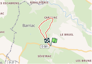
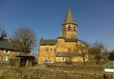
Tocht Te voet van 3,9 km beschikbaar op Occitanië, Aveyron, Bozouls. Deze tocht wordt voorgesteld door Strabidja.
Beschrijving
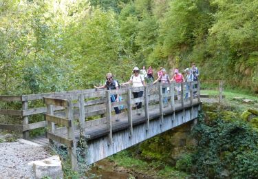
Petite marche tranquille de 4 km, entièrement par un chemin large sauf depuis "CARCUAC" où vous suivrez la route de campagne, où nous n'avons croisé aucune voiture, sur environ 800m avant de reprendre à droite pour faire la boucle...
Plaatsbepaling
Land:
France
Regio :
Occitanië
Departement/Provincie :
Aveyron
Gemeente :
Bozouls
Locatie:
Unknown
Vertrek:(Dec)
Vertrek:(UTM)
474292 ; 4922994 (31T) N.
Opmerkingen
Wandeltochten in de omgeving
![Tocht Te voet Sébazac-Concourès - Circuit 17 Concourès - Photo](https://media.geolcdn.com/t/375/260/048b604d-2a3b-4b6a-b53f-bf6a713ff99b.jpeg&format=jpg&maxdim=2)
![Te voet Te voet](https://static1.geolcdn.com/sitytour/trail-icons/100.png)
Circuit 17 Concourès
Te voet
Gemakkelijk
Sébazac-Concourès,
Occitanië,
Aveyron,
France
![](/images/other/stat-length.png)
9 km | 10,6 km-effort
2h 24min
![](https://static1.geolcdn.com/siteimages/upload/files/16400158638029165_repeat_loop_refresh_sync_direction_icon.png)
Ja
![Tocht Stappen Rodelle - BEZONNES Nord - Photo](https://media.geolcdn.com/t/375/260/ext.jpg?maxdim=2&url=https%3A%2F%2Fstatic1.geolcdn.com%2Fsiteimages%2Fupload%2Ffiles%2F1553511878bg_sport_marche.png)
![Stappen Stappen](https://static1.geolcdn.com/sitytour/trail-icons/101.png)
BEZONNES Nord
Stappen
Medium
(1)
Rodelle,
Occitanië,
Aveyron,
France
![](/images/other/stat-length.png)
6 km | 6,3 km-effort
1h 25min
![](https://static1.geolcdn.com/siteimages/upload/files/16400158638029165_repeat_loop_refresh_sync_direction_icon.png)
Ja
![Tocht Stappen Bozouls - Trou de Bozouls - Photo](https://media.geolcdn.com/t/375/260/ext.jpg?maxdim=2&url=https%3A%2F%2Fstatic1.geolcdn.com%2Fsiteimages%2Fupload%2Ffiles%2F1553511878bg_sport_marche.png)
![Stappen Stappen](https://static1.geolcdn.com/sitytour/trail-icons/101.png)
Trou de Bozouls
Stappen
Gemakkelijk
(4)
Bozouls,
Occitanië,
Aveyron,
France
![](/images/other/stat-length.png)
14,5 km | 19,9 km-effort
4h 15min
![](https://static1.geolcdn.com/siteimages/upload/files/16400158638029165_repeat_loop_refresh_sync_direction_icon.png)
Ja
![Tocht Mountainbike Rodelle - Ledenac 2 - Photo](https://media.geolcdn.com/t/375/260/ext.jpg?maxdim=2&url=https%3A%2F%2Fstatic1.geolcdn.com%2Fsiteimages%2Fupload%2Ffiles%2F1524743154velo.jpg)
![Mountainbike Mountainbike](https://static1.geolcdn.com/sitytour/trail-icons/202.png)
Ledenac 2
Mountainbike
Heel gemakkelijk
(1)
Rodelle,
Occitanië,
Aveyron,
France
![](/images/other/stat-length.png)
5,5 km | 6,8 km-effort
Onbekend
![](https://static1.geolcdn.com/siteimages/upload/files/16400158638029165_repeat_loop_refresh_sync_direction_icon.png)
Neen
![Tocht Te voet Bozouls - De Bozouls à Rodelle - Photo](https://media.geolcdn.com/t/375/260/66d69220-9bbc-4663-b00f-c4b699fabe9e.jpeg&format=jpg&maxdim=2)
![Te voet Te voet](https://static1.geolcdn.com/sitytour/trail-icons/100.png)
De Bozouls à Rodelle
Te voet
Gemakkelijk
Bozouls,
Occitanië,
Aveyron,
France
![](/images/other/stat-length.png)
10,4 km | 13,6 km-effort
3h 4min
![](https://static1.geolcdn.com/siteimages/upload/files/16400158638029165_repeat_loop_refresh_sync_direction_icon.png)
Neen
![Stappen Stappen](https://static1.geolcdn.com/sitytour/trail-icons/101.png)
Bozoul (Après-midi)
Stappen
Gemakkelijk
Bozouls,
Occitanië,
Aveyron,
France
![](/images/other/stat-length.png)
4,8 km | 6,6 km-effort
2h 0min
![](https://static1.geolcdn.com/siteimages/upload/files/16400158638029165_repeat_loop_refresh_sync_direction_icon.png)
Ja
![Tocht Stappen Bozouls - Horizons et Clochers du Rouergue - Gillorgues - Photo](https://media.geolcdn.com/t/375/260/ext.jpg?maxdim=2&url=https%3A%2F%2Fservices.sitytrail.com%2FGeolivesWS%2FDownloadMedia.ashx%3FTrailID%3D118794%26Media%3D13001_3.jpg)
![Stappen Stappen](https://static1.geolcdn.com/sitytour/trail-icons/101.png)
Horizons et Clochers du Rouergue - Gillorgues
Stappen
Medium
Bozouls,
Occitanië,
Aveyron,
France
![](/images/other/stat-length.png)
11,9 km | 15,5 km-effort
3h 0min
![](https://static1.geolcdn.com/siteimages/upload/files/16400158638029165_repeat_loop_refresh_sync_direction_icon.png)
Ja
![Tocht Stappen Bozouls - De Barriac à Rodelle - Photo](https://media.geolcdn.com/t/375/260/ext.jpg?maxdim=2&url=https%3A%2F%2Fservices.sitytrail.com%2FGeolivesWS%2FDownloadMedia.ashx%3FTrailID%3D106448%26Media%3D10959_6.jpg)
![Stappen Stappen](https://static1.geolcdn.com/sitytour/trail-icons/101.png)
De Barriac à Rodelle
Stappen
Medium
Bozouls,
Occitanië,
Aveyron,
France
![](/images/other/stat-length.png)
12,3 km | 16,5 km-effort
3h 15min
![](https://static1.geolcdn.com/siteimages/upload/files/16400158638029165_repeat_loop_refresh_sync_direction_icon.png)
Ja
![Tocht Mountainbike Bozouls - Roquelaure au départ de Bozouls - Photo](https://media.geolcdn.com/t/375/260/ext.jpg?maxdim=2&url=https%3A%2F%2Fservices.sitytrail.com%2FGeolivesWS%2FDownloadMedia.ashx%3FTrailID%3D106345%26Media%3D10807_4.jpg)
![Mountainbike Mountainbike](https://static1.geolcdn.com/sitytour/trail-icons/202.png)
Roquelaure au départ de Bozouls
Mountainbike
Moeilijk
Bozouls,
Occitanië,
Aveyron,
France
![](/images/other/stat-length.png)
33 km | 43 km-effort
4h 19min
![](https://static1.geolcdn.com/siteimages/upload/files/16400158638029165_repeat_loop_refresh_sync_direction_icon.png)
Ja