![](/images/other/stat-length.png)
![Tocht Mountainbike Villasavary - circuit 3 villasavary - Photo](https://media.geolcdn.com/t/1900/400/ext.pjpeg?maxdim=2&url=https%3A%2F%2Fstatic1.geolcdn.com%2Fsiteimages%2Fupload%2Ffiles%2F1524743154velo.jpg)
circuit 3 villasavary
leroj73
Gebruiker
![Lengte](/images/other/stat-length.png)
Lengte
23 km
![Max. hoogte](https://static1.geolcdn.com/siteimages/upload/files/1508320355ic_sort_altitude_max_24dp.png)
Max. hoogte
369 m
![Positief hoogteverschil](https://static1.geolcdn.com/siteimages/upload/files/1508320355ic_sort_den_pos_24dp.png)
Positief hoogteverschil
546 m
![Km-Effort](/images/other/stat-length.png)
Km-Effort
30 km
![Min. hoogte](https://static1.geolcdn.com/siteimages/upload/files/1508320355ic_sort_altitude_min_24dp.png)
Min. hoogte
180 m
![Negatief hoogteverschil](https://static1.geolcdn.com/siteimages/upload/files/1508320355ic_sort_den_neg_24dp.png)
Negatief hoogteverschil
546 m
![Boucle](https://static1.geolcdn.com/siteimages/upload/files/16400158638029165_repeat_loop_refresh_sync_direction_icon.png)
Boucle
Ja
Datum van aanmaak :
2019-02-21 10:34:58.75
Laatste wijziging :
2019-02-21 13:00:21.956
![Mountainbike](https://static1.geolcdn.com/sitytour/trail-icons/202.png)
1h43
Moeilijkheid : Medium
![Scan deze QR-code om de tocht te openen in de SityTrail-applicatie](https://capi.geolives.com/qq0zvz2zws4bq2lad0pu/sitytour/trails/2037754/qr.png?size=200)
Gratisgps-wandelapplicatie
Over ons
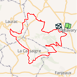
Tocht Mountainbike van 23 km beschikbaar op Occitanië, Aude, Villasavary. Deze tocht wordt voorgesteld door leroj73.
Beschrijving
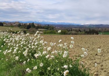
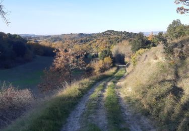
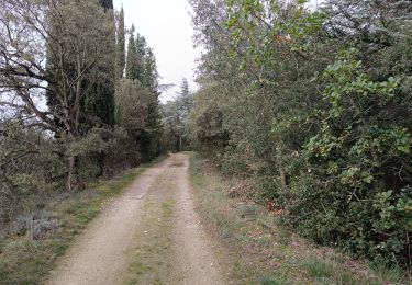
parcours ludique avec des "coups de culs" bien cassant. de superbes cingles pour un finich en douceurs. des points de vue magnigiques sur les collines audoises
Plaatsbepaling
Land:
France
Regio :
Occitanië
Departement/Provincie :
Aude
Gemeente :
Villasavary
Locatie:
Unknown
Vertrek:(Dec)
Vertrek:(UTM)
421647 ; 4785531 (31T) N.
Opmerkingen
Wandeltochten in de omgeving
![Tocht Stappen Lasserre-de-Prouille - Lasserre de prouilhe 17 kms - Photo](https://media.geolcdn.com/t/375/260/42883d80-03fb-4801-b4d9-76324b238337.jpg&format=jpg&maxdim=2)
![Stappen Stappen](https://static1.geolcdn.com/sitytour/trail-icons/101.png)
Lasserre de prouilhe 17 kms
Stappen
Medium
(1)
Lasserre-de-Prouille,
Occitanië,
Aude,
France
![](/images/other/stat-length.png)
16,9 km | 21 km-effort
4h 25min
![](https://static1.geolcdn.com/siteimages/upload/files/16400158638029165_repeat_loop_refresh_sync_direction_icon.png)
Ja
![Tocht Stappen Fanjeaux - Fanjeaux la hilhe - Photo](https://media.geolcdn.com/t/375/260/f6412b6b-058a-4d88-bc2b-7b88d52b5436.jpg&format=jpg&maxdim=2)
![Stappen Stappen](https://static1.geolcdn.com/sitytour/trail-icons/101.png)
Fanjeaux la hilhe
Stappen
Moeilijk
(1)
Fanjeaux,
Occitanië,
Aude,
France
![](/images/other/stat-length.png)
9,7 km | 13,2 km-effort
3h 0min
![](https://static1.geolcdn.com/siteimages/upload/files/16400158638029165_repeat_loop_refresh_sync_direction_icon.png)
Neen
![Tocht Stappen Villasavary - La grande boucle des paysages Villasavary - Photo](https://media.geolcdn.com/t/375/260/ext.jpg?maxdim=2&url=https%3A%2F%2Fstatic1.geolcdn.com%2Fsiteimages%2Fupload%2Ffiles%2F1553511878bg_sport_marche.png)
![Stappen Stappen](https://static1.geolcdn.com/sitytour/trail-icons/101.png)
La grande boucle des paysages Villasavary
Stappen
Zeer moeilijk
(1)
Villasavary,
Occitanië,
Aude,
France
![](/images/other/stat-length.png)
14,5 km | 19,5 km-effort
4h 26min
![](https://static1.geolcdn.com/siteimages/upload/files/16400158638029165_repeat_loop_refresh_sync_direction_icon.png)
Ja
![Tocht Stappen Laurac - Laurac Fanjeaux - Photo](https://media.geolcdn.com/t/375/260/ext.jpg?maxdim=2&url=https%3A%2F%2Fstatic1.geolcdn.com%2Fsiteimages%2Fupload%2Ffiles%2F1553511878bg_sport_marche.png)
![Stappen Stappen](https://static1.geolcdn.com/sitytour/trail-icons/101.png)
Laurac Fanjeaux
Stappen
Zeer moeilijk
(1)
Laurac,
Occitanië,
Aude,
France
![](/images/other/stat-length.png)
27 km | 37 km-effort
6h 30min
![](https://static1.geolcdn.com/siteimages/upload/files/16400158638029165_repeat_loop_refresh_sync_direction_icon.png)
Ja
![Tocht Stappen Villasavary - Tour Montcarrière depuis Monplaisir - Photo](https://media.geolcdn.com/t/375/260/a9da3a29-3ab0-45ae-b347-a58298266fbd.jpg&format=jpg&maxdim=2)
![Stappen Stappen](https://static1.geolcdn.com/sitytour/trail-icons/101.png)
Tour Montcarrière depuis Monplaisir
Stappen
Medium
Villasavary,
Occitanië,
Aude,
France
![](/images/other/stat-length.png)
4,6 km | 6,5 km-effort
1h 28min
![](https://static1.geolcdn.com/siteimages/upload/files/16400158638029165_repeat_loop_refresh_sync_direction_icon.png)
Ja
![Tocht Stappen Villasavary - Besplas 2 - Photo](https://media.geolcdn.com/t/375/260/f1b0f82c-2a82-4fe5-83d3-1026f876e8e3.jpg&format=jpg&maxdim=2)
![Stappen Stappen](https://static1.geolcdn.com/sitytour/trail-icons/101.png)
![Tocht Stappen Fanjeaux - Fanjeaux Boucle de la Hille - Photo](https://media.geolcdn.com/t/375/260/4eabae97-86a4-4cd4-a60d-69fc6661f48a.jpg&format=jpg&maxdim=2)
![Stappen Stappen](https://static1.geolcdn.com/sitytour/trail-icons/101.png)
Fanjeaux Boucle de la Hille
Stappen
Medium
Fanjeaux,
Occitanië,
Aude,
France
![](/images/other/stat-length.png)
13,1 km | 18,3 km-effort
3h 30min
![](https://static1.geolcdn.com/siteimages/upload/files/16400158638029165_repeat_loop_refresh_sync_direction_icon.png)
Ja
![Tocht Mountainbike Laurabuc - boucle bb - Photo](https://media.geolcdn.com/t/375/260/ext.jpg?maxdim=2&url=https%3A%2F%2Fstatic1.geolcdn.com%2Fsiteimages%2Fupload%2Ffiles%2F1524743154velo.jpg)
![Mountainbike Mountainbike](https://static1.geolcdn.com/sitytour/trail-icons/202.png)
boucle bb
Mountainbike
Gemakkelijk
(1)
Laurabuc,
Occitanië,
Aude,
France
![](/images/other/stat-length.png)
15,2 km | 19,2 km-effort
1h 15min
![](https://static1.geolcdn.com/siteimages/upload/files/16400158638029165_repeat_loop_refresh_sync_direction_icon.png)
Ja
![Tocht Stappen Fanjeaux - Chemin du Piémont Pyrénéen - de Fanjeaux à Mirepoix - Photo](https://media.geolcdn.com/t/375/260/ext.jpg?maxdim=2&url=https%3A%2F%2Fservices.sitytrail.com%2FGeolivesWS%2FDownloadMedia.ashx%3FTrailID%3D106442%26Media%3D10951_4.jpg)
![Stappen Stappen](https://static1.geolcdn.com/sitytour/trail-icons/101.png)
Chemin du Piémont Pyrénéen - de Fanjeaux à Mirepoix
Stappen
Moeilijk
(1)
Fanjeaux,
Occitanië,
Aude,
France
![](/images/other/stat-length.png)
26 km | 33 km-effort
6h 0min
![](https://static1.geolcdn.com/siteimages/upload/files/16400158638029165_repeat_loop_refresh_sync_direction_icon.png)
Neen
A faire. sur le site du club vtt. lous pounpils...ils font un travail de fou. merci pour leurs tracés