![](/images/other/stat-length.png)
![Tocht Te voet Chaumes-en-Retz - jcyol44 arthon en retz via chéméré - Photo](https://media.geolcdn.com/t/1900/400/ext.pjpeg?maxdim=2&url=https%3A%2F%2Fstatic1.geolcdn.com%2Fsiteimages%2Fupload%2Ffiles%2F1545311037marcheuse_200dpi.jpg)
jcyol44 arthon en retz via chéméré
JCYOL44
Gebruiker
![Lengte](/images/other/stat-length.png)
![Max. hoogte](https://static1.geolcdn.com/siteimages/upload/files/1508320355ic_sort_altitude_max_24dp.png)
![Positief hoogteverschil](https://static1.geolcdn.com/siteimages/upload/files/1508320355ic_sort_den_pos_24dp.png)
![Km-Effort](/images/other/stat-length.png)
![Min. hoogte](https://static1.geolcdn.com/siteimages/upload/files/1508320355ic_sort_altitude_min_24dp.png)
![Negatief hoogteverschil](https://static1.geolcdn.com/siteimages/upload/files/1508320355ic_sort_den_neg_24dp.png)
![Boucle](https://static1.geolcdn.com/siteimages/upload/files/16400158638029165_repeat_loop_refresh_sync_direction_icon.png)
![Te voet](https://static1.geolcdn.com/sitytour/trail-icons/100.png)
2h20
Moeilijkheid : Heel gemakkelijk
![Scan deze QR-code om de tocht te openen in de SityTrail-applicatie](https://capi.geolives.com/qq0zvz2zws4bq2lad0pu/sitytour/trails/2035446/qr.png?size=200)
Gratisgps-wandelapplicatie
Over ons
Tocht Te voet van 9,6 km beschikbaar op Pays de la Loire, Loire-Atlantique, Chaumes-en-Retz. Deze tocht wordt voorgesteld door JCYOL44.
Beschrijving
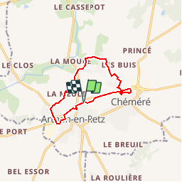
Petite boucle d'environ 10km sans difficulté..
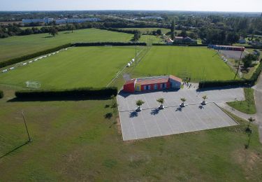
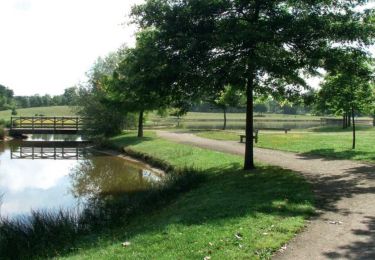
Départ / arrivée du parking de la salle de sports. Partir en longeant la D751 puis passer le pont sur votre droite .Sur la D5. Traverser la D5 en direction de La Meule. Sur votre gauche prendre un chemin qui vous emmène vers La Danjollerie. Arrivé au Plessis, tourner à droite jusqu'au parc de Chéméré; en faire le tour puis longer à nouveau la D751 jusqu'au parking.
Plaatsbepaling
Opmerkingen
Wandeltochten in de omgeving
![Tocht Te voet Chaumes-en-Retz - Sentier pédestre des Iles Enchantées - Photo](https://media.geolcdn.com/t/375/260/8d9b3652-bedc-4903-8d23-e450b9c65d96.jpeg&format=jpg&maxdim=2)
![Te voet Te voet](https://static1.geolcdn.com/sitytour/trail-icons/100.png)
Te voet
![](/images/other/stat-length.png)
![](https://static1.geolcdn.com/siteimages/upload/files/16400158638029165_repeat_loop_refresh_sync_direction_icon.png)
![Tocht Te voet Chaumes-en-Retz - Circuit des Chênes - Photo](https://media.geolcdn.com/t/375/260/7606bf5a-2198-4218-abf5-a4d4ae02cf42.jpeg&format=jpg&maxdim=2)
![Te voet Te voet](https://static1.geolcdn.com/sitytour/trail-icons/100.png)
Te voet
![](/images/other/stat-length.png)
![](https://static1.geolcdn.com/siteimages/upload/files/16400158638029165_repeat_loop_refresh_sync_direction_icon.png)
![Tocht Stappen Chaumes-en-Retz - Arthon Chemere - Photo](https://media.geolcdn.com/t/375/260/5c2166da-4a74-4ba7-a499-c7af068420f8.jpg&format=jpg&maxdim=2)
![Stappen Stappen](https://static1.geolcdn.com/sitytour/trail-icons/101.png)
Stappen
![](/images/other/stat-length.png)
![](https://static1.geolcdn.com/siteimages/upload/files/16400158638029165_repeat_loop_refresh_sync_direction_icon.png)
![Tocht Mountainbike Chaumes-en-Retz - de Arthon en Retz par le Prépaud - Photo](https://media.geolcdn.com/t/375/260/ext.jpg?maxdim=2&url=https%3A%2F%2Fstatic1.geolcdn.com%2Fsiteimages%2Fupload%2Ffiles%2F1524743154velo.jpg)
![Mountainbike Mountainbike](https://static1.geolcdn.com/sitytour/trail-icons/202.png)
Mountainbike
![](/images/other/stat-length.png)
![](https://static1.geolcdn.com/siteimages/upload/files/16400158638029165_repeat_loop_refresh_sync_direction_icon.png)
![Tocht Hybride fiets Chaumes-en-Retz - Belle Épine lac de Pornic - Photo](https://media.geolcdn.com/t/375/260/4196bce5-8058-43cf-9aa2-712e6b61de2a.jpg&format=jpg&maxdim=2)
![Hybride fiets Hybride fiets](https://static1.geolcdn.com/sitytour/trail-icons/203.png)
Hybride fiets
![](/images/other/stat-length.png)
![](https://static1.geolcdn.com/siteimages/upload/files/16400158638029165_repeat_loop_refresh_sync_direction_icon.png)
![Tocht Te voet Chaumes-en-Retz - D'Arthon à La Sicaudais - Photo](https://media.geolcdn.com/t/375/260/39754271-52c4-4067-8a63-e67370b7bbbe.jpeg&format=jpg&maxdim=2)
![Te voet Te voet](https://static1.geolcdn.com/sitytour/trail-icons/100.png)
Te voet
![](/images/other/stat-length.png)
![](https://static1.geolcdn.com/siteimages/upload/files/16400158638029165_repeat_loop_refresh_sync_direction_icon.png)
![Tocht Te voet Chaumes-en-Retz - Circuit de Haute-Perche - Photo](https://media.geolcdn.com/t/375/260/39754271-52c4-4067-8a63-e67370b7bbbe.jpeg&format=jpg&maxdim=2)
![Te voet Te voet](https://static1.geolcdn.com/sitytour/trail-icons/100.png)
Te voet
![](/images/other/stat-length.png)
![](https://static1.geolcdn.com/siteimages/upload/files/16400158638029165_repeat_loop_refresh_sync_direction_icon.png)
![Tocht Mountainbike Chaumes-en-Retz - Belle épine/Ste Pazane - Photo](https://media.geolcdn.com/t/375/260/91857525-f683-4e66-91a0-3b82395a892f.jpg&format=jpg&maxdim=2)
![Mountainbike Mountainbike](https://static1.geolcdn.com/sitytour/trail-icons/202.png)
Mountainbike
![](/images/other/stat-length.png)
![](https://static1.geolcdn.com/siteimages/upload/files/16400158638029165_repeat_loop_refresh_sync_direction_icon.png)
![Tocht Stappen Chaumes-en-Retz - Les Chênes - Photo](https://media.geolcdn.com/t/375/260/ac7d3175-0270-486b-af63-acac79c92b63.jpg&format=jpg&maxdim=2)
![Stappen Stappen](https://static1.geolcdn.com/sitytour/trail-icons/101.png)
Stappen
![](/images/other/stat-length.png)
![](https://static1.geolcdn.com/siteimages/upload/files/16400158638029165_repeat_loop_refresh_sync_direction_icon.png)