![](/images/other/stat-length.png)
![Tocht Andere activiteiten Dallenwil - Wirzweli - Gummenalp -Langboden - Wirzweli - Photo](https://media.geolcdn.com/t/1900/400/ext.pjpeg?maxdim=2&url=https%3A%2F%2Fstatic1.geolcdn.com%2Fsiteimages%2Fupload%2Ffiles%2F1545311037marcheuse_200dpi.jpg)
Wirzweli - Gummenalp -Langboden - Wirzweli
jschna
Gebruiker
![Lengte](/images/other/stat-length.png)
![Max. hoogte](https://static1.geolcdn.com/siteimages/upload/files/1508320355ic_sort_altitude_max_24dp.png)
![Positief hoogteverschil](https://static1.geolcdn.com/siteimages/upload/files/1508320355ic_sort_den_pos_24dp.png)
![Km-Effort](/images/other/stat-length.png)
![Min. hoogte](https://static1.geolcdn.com/siteimages/upload/files/1508320355ic_sort_altitude_min_24dp.png)
![Negatief hoogteverschil](https://static1.geolcdn.com/siteimages/upload/files/1508320355ic_sort_den_neg_24dp.png)
![Boucle](https://static1.geolcdn.com/siteimages/upload/files/16400158638029165_repeat_loop_refresh_sync_direction_icon.png)
![Andere activiteiten](https://static1.geolcdn.com/sitytour/trail-icons/900.png)
--
Moeilijkheid : Onbekend
![Scan deze QR-code om de tocht te openen in de SityTrail-applicatie](https://capi.geolives.com/qq0zvz2zws4bq2lad0pu/sitytour/trails/20259/qr.png?size=200)
Gratisgps-wandelapplicatie
Over ons
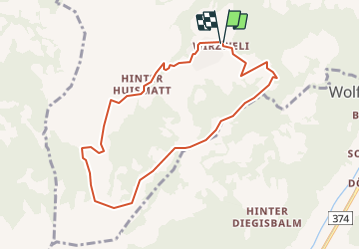
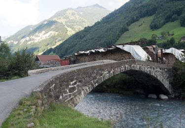
Tocht Andere activiteiten van 8,2 km beschikbaar op Nidwalden, Onbekend, Dallenwil. Deze tocht wordt voorgesteld door jschna.
Beschrijving
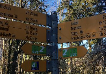
Ab Wirzweli (1200m) leichter Aufstieg zum Wirzweli Horn (1417m). Einmaliger Panoramaweg über den Wirzweligrat bis zur Gummenalp (1600m). Über saftige Alpwiesen inmitten der Natur führt Sie ein leicht abfallender Weg zu den Alpen unterer Rohne, Dürrenboden und Alp Langobden (1304m). Nach ca 30 Minuten gelangen Sie wieder zum Wirzweli zurück.
Plaatsbepaling
Opmerkingen
Wandeltochten in de omgeving
![Tocht Te voet Dallenwil - Wirzweli - Gummenalp - Photo](https://media.geolcdn.com/t/375/260/22814123-4ae5-4ead-a79a-8a596a7474e1.jpeg&format=jpg&maxdim=2)
![Te voet Te voet](https://static1.geolcdn.com/sitytour/trail-icons/100.png)
Te voet
![](/images/other/stat-length.png)
![](https://static1.geolcdn.com/siteimages/upload/files/16400158638029165_repeat_loop_refresh_sync_direction_icon.png)
![Tocht Te voet Dallenwil - Dominikpfad - Photo](https://media.geolcdn.com/t/375/260/02cd09a1-c950-4c1e-87d5-0b204c8f863f.jpeg&format=jpg&maxdim=2)
![Te voet Te voet](https://static1.geolcdn.com/sitytour/trail-icons/100.png)
Te voet
![](/images/other/stat-length.png)
![](https://static1.geolcdn.com/siteimages/upload/files/16400158638029165_repeat_loop_refresh_sync_direction_icon.png)
![Tocht Te voet Engelberg - Grafenort - Obermatt - Photo](https://media.geolcdn.com/t/375/260/bafa5a1b-5de4-4ea0-984e-312abafce2e5.jpeg&format=jpg&maxdim=2)
![Te voet Te voet](https://static1.geolcdn.com/sitytour/trail-icons/100.png)
Te voet
![](/images/other/stat-length.png)
![](https://static1.geolcdn.com/siteimages/upload/files/16400158638029165_repeat_loop_refresh_sync_direction_icon.png)
![Tocht Te voet Wolfenschiessen - Diegischbalm - Nechimatt - Photo](https://media.geolcdn.com/t/375/260/730f9f5c-202d-4254-a2ca-569e3eeac4c9.jpeg&format=jpg&maxdim=2)
![Te voet Te voet](https://static1.geolcdn.com/sitytour/trail-icons/100.png)
Te voet
![](/images/other/stat-length.png)
![](https://static1.geolcdn.com/siteimages/upload/files/16400158638029165_repeat_loop_refresh_sync_direction_icon.png)
![Tocht Te voet Wolfenschiessen - Kapellenweg - Photo](https://media.geolcdn.com/t/375/260/bafa5a1b-5de4-4ea0-984e-312abafce2e5.jpeg&format=jpg&maxdim=2)
![Te voet Te voet](https://static1.geolcdn.com/sitytour/trail-icons/100.png)
Te voet
![](/images/other/stat-length.png)
![](https://static1.geolcdn.com/siteimages/upload/files/16400158638029165_repeat_loop_refresh_sync_direction_icon.png)
![Tocht Te voet Stans - Bruder-Klausen-Weg - Photo](https://media.geolcdn.com/t/375/260/19b3f499-89ec-405e-a7a8-5847cc6333f7.jpeg&format=jpg&maxdim=2)
![Te voet Te voet](https://static1.geolcdn.com/sitytour/trail-icons/100.png)
Te voet
![](/images/other/stat-length.png)
![](https://static1.geolcdn.com/siteimages/upload/files/16400158638029165_repeat_loop_refresh_sync_direction_icon.png)
![Tocht Te voet Kerns - St Jakob - Ächerli - Photo](https://media.geolcdn.com/t/375/260/92daf0b2-5661-47c4-8428-48a4af8c3bc0.jpeg&format=jpg&maxdim=2)
![Te voet Te voet](https://static1.geolcdn.com/sitytour/trail-icons/100.png)
Te voet
![](/images/other/stat-length.png)
![](https://static1.geolcdn.com/siteimages/upload/files/16400158638029165_repeat_loop_refresh_sync_direction_icon.png)
![Tocht Te voet Dallenwil - Langboden - Gummenalp - Photo](https://media.geolcdn.com/t/375/260/ext.jpg?maxdim=2&url=https%3A%2F%2Fstatic1.geolcdn.com%2Fsiteimages%2Fupload%2Ffiles%2F1545311037marcheuse_200dpi.jpg)
![Te voet Te voet](https://static1.geolcdn.com/sitytour/trail-icons/100.png)
Te voet
![](/images/other/stat-length.png)
![](https://static1.geolcdn.com/siteimages/upload/files/16400158638029165_repeat_loop_refresh_sync_direction_icon.png)
![Tocht Te voet Stans - Luegeren - Ägertli - fixme - Photo](https://media.geolcdn.com/t/375/260/ext.jpg?maxdim=2&url=https%3A%2F%2Fstatic1.geolcdn.com%2Fsiteimages%2Fupload%2Ffiles%2F1545311037marcheuse_200dpi.jpg)
![Te voet Te voet](https://static1.geolcdn.com/sitytour/trail-icons/100.png)
Te voet
![](/images/other/stat-length.png)
![](https://static1.geolcdn.com/siteimages/upload/files/16400158638029165_repeat_loop_refresh_sync_direction_icon.png)