![](/images/other/stat-length.png)
![Tocht Andere activiteiten Flims - Flims - Bargis - Photo](https://media.geolcdn.com/t/1900/400/ext.pjpeg?maxdim=2&url=https%3A%2F%2Fstatic1.geolcdn.com%2Fsiteimages%2Fupload%2Ffiles%2F1545311037marcheuse_200dpi.jpg)
Flims - Bargis
jschna
Gebruiker
![Lengte](/images/other/stat-length.png)
![Max. hoogte](https://static1.geolcdn.com/siteimages/upload/files/1508320355ic_sort_altitude_max_24dp.png)
![Positief hoogteverschil](https://static1.geolcdn.com/siteimages/upload/files/1508320355ic_sort_den_pos_24dp.png)
![Km-Effort](/images/other/stat-length.png)
![Min. hoogte](https://static1.geolcdn.com/siteimages/upload/files/1508320355ic_sort_altitude_min_24dp.png)
![Negatief hoogteverschil](https://static1.geolcdn.com/siteimages/upload/files/1508320355ic_sort_den_neg_24dp.png)
![Boucle](https://static1.geolcdn.com/siteimages/upload/files/16400158638029165_repeat_loop_refresh_sync_direction_icon.png)
![Andere activiteiten](https://static1.geolcdn.com/sitytour/trail-icons/900.png)
--
Moeilijkheid : Onbekend
![Scan deze QR-code om de tocht te openen in de SityTrail-applicatie](https://capi.geolives.com/qq0zvz2zws4bq2lad0pu/sitytour/trails/20251/qr.png?size=200)
Gratisgps-wandelapplicatie
Over ons
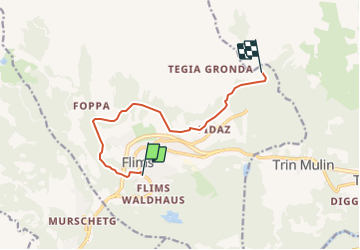
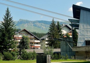
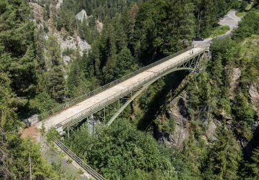
Tocht Andere activiteiten van 8,5 km beschikbaar op Graubünden, Imboden, Flims. Deze tocht wordt voorgesteld door jschna.
Beschrijving
Unterhalb vom Hotel Chesa den Aufstieg über den signalisierten Wanderweg nehmen.
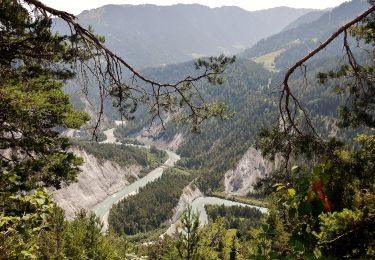
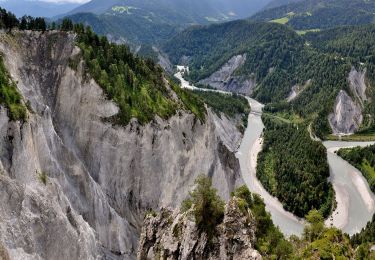
Über Spaligna nach Scheia, immer auf dem Höhenweg bis nach Bargis, wo sich ein leistungsfähiges Restaurant befindet und eine wunderschöne Aussicht ins Tal bietet.
Rückfahrt mit dem Bus (alle 30 Min.) nach Flims.
Plaatsbepaling
Opmerkingen
Wandeltochten in de omgeving
![Tocht Te voet Flims - Conn - Cresta See - Photo](https://media.geolcdn.com/t/375/260/1e9e186c-c404-4d25-97ce-94522e729cc7.jpeg&format=jpg&maxdim=2)
![Te voet Te voet](https://static1.geolcdn.com/sitytour/trail-icons/100.png)
Te voet
![](/images/other/stat-length.png)
![](https://static1.geolcdn.com/siteimages/upload/files/16400158638029165_repeat_loop_refresh_sync_direction_icon.png)
![Tocht Te voet Safiental - Station Versam-Safien - Versam - Photo](https://media.geolcdn.com/t/375/260/dev_6749a509-cf02-4174-9a3b-ba7f44fa5e7a.jpeg&format=jpg&maxdim=2)
![Te voet Te voet](https://static1.geolcdn.com/sitytour/trail-icons/100.png)
Te voet
![](/images/other/stat-length.png)
![](https://static1.geolcdn.com/siteimages/upload/files/16400158638029165_repeat_loop_refresh_sync_direction_icon.png)
![Tocht Te voet Flims - Flims-Conn - Photo](https://media.geolcdn.com/t/375/260/1880d78b-ac46-4df8-8036-ec2998894eb0.jpeg&format=jpg&maxdim=2)
![Te voet Te voet](https://static1.geolcdn.com/sitytour/trail-icons/100.png)
Te voet
![](/images/other/stat-length.png)
![](https://static1.geolcdn.com/siteimages/upload/files/16400158638029165_repeat_loop_refresh_sync_direction_icon.png)
![Tocht Te voet Laax - Curnius - Laax - Photo](https://media.geolcdn.com/t/375/260/d810f58f-ccd0-489f-b82a-e8d6a07ec481.jpeg&format=jpg&maxdim=2)
![Te voet Te voet](https://static1.geolcdn.com/sitytour/trail-icons/100.png)
Te voet
![](/images/other/stat-length.png)
![](https://static1.geolcdn.com/siteimages/upload/files/16400158638029165_repeat_loop_refresh_sync_direction_icon.png)
![Tocht Te voet Falera - Curnius - Falera - Photo](https://media.geolcdn.com/t/375/260/be32cecb-6f68-4336-99b1-5c04a02da7b0.jpeg&format=jpg&maxdim=2)
![Te voet Te voet](https://static1.geolcdn.com/sitytour/trail-icons/100.png)
Te voet
![](/images/other/stat-length.png)
![](https://static1.geolcdn.com/siteimages/upload/files/16400158638029165_repeat_loop_refresh_sync_direction_icon.png)
![Tocht Te voet Laax - Larnags-Runca-Flims - Photo](https://media.geolcdn.com/t/375/260/fa421d67-b970-4ac0-95a5-cc762e710df7.jpeg&format=jpg&maxdim=2)
![Te voet Te voet](https://static1.geolcdn.com/sitytour/trail-icons/100.png)
Te voet
![](/images/other/stat-length.png)
![](https://static1.geolcdn.com/siteimages/upload/files/16400158638029165_repeat_loop_refresh_sync_direction_icon.png)
![Tocht Te voet Safiental - Valendas-Castrisch - Photo](https://media.geolcdn.com/t/375/260/7f6a0ff4-164c-4e87-9ce9-4e8c856a66ea.jpeg&format=jpg&maxdim=2)
![Te voet Te voet](https://static1.geolcdn.com/sitytour/trail-icons/100.png)
Te voet
![](/images/other/stat-length.png)
![](https://static1.geolcdn.com/siteimages/upload/files/16400158638029165_repeat_loop_refresh_sync_direction_icon.png)
![Tocht Te voet Safiental - Versam - Carerra - Photo](https://media.geolcdn.com/t/375/260/a46c6e8a-f55a-413f-9275-4fd31e9d4b64.jpeg&format=jpg&maxdim=2)
![Te voet Te voet](https://static1.geolcdn.com/sitytour/trail-icons/100.png)
Te voet
![](/images/other/stat-length.png)
![](https://static1.geolcdn.com/siteimages/upload/files/16400158638029165_repeat_loop_refresh_sync_direction_icon.png)
![Tocht Te voet Safiental - Station Versam-Station Valendas - Photo](https://media.geolcdn.com/t/375/260/dev_6749a509-cf02-4174-9a3b-ba7f44fa5e7a.jpeg&format=jpg&maxdim=2)
![Te voet Te voet](https://static1.geolcdn.com/sitytour/trail-icons/100.png)
Te voet
![](/images/other/stat-length.png)
![](https://static1.geolcdn.com/siteimages/upload/files/16400158638029165_repeat_loop_refresh_sync_direction_icon.png)