![](/images/other/stat-length.png)
![Tocht Andere activiteiten Walenstadt - Walenstadt - Quinten - Photo](https://media.geolcdn.com/t/1900/400/ext.pjpeg?maxdim=2&url=https%3A%2F%2Fstatic1.geolcdn.com%2Fsiteimages%2Fupload%2Ffiles%2F1545311037marcheuse_200dpi.jpg)
Walenstadt - Quinten
jschna
Gebruiker
![Lengte](/images/other/stat-length.png)
![Max. hoogte](https://static1.geolcdn.com/siteimages/upload/files/1508320355ic_sort_altitude_max_24dp.png)
![Positief hoogteverschil](https://static1.geolcdn.com/siteimages/upload/files/1508320355ic_sort_den_pos_24dp.png)
![Km-Effort](/images/other/stat-length.png)
![Min. hoogte](https://static1.geolcdn.com/siteimages/upload/files/1508320355ic_sort_altitude_min_24dp.png)
![Negatief hoogteverschil](https://static1.geolcdn.com/siteimages/upload/files/1508320355ic_sort_den_neg_24dp.png)
![Boucle](https://static1.geolcdn.com/siteimages/upload/files/16400158638029165_repeat_loop_refresh_sync_direction_icon.png)
![Andere activiteiten](https://static1.geolcdn.com/sitytour/trail-icons/900.png)
--
Moeilijkheid : Onbekend
![Scan deze QR-code om de tocht te openen in de SityTrail-applicatie](https://capi.geolives.com/qq0zvz2zws4bq2lad0pu/sitytour/trails/20238/qr.png?size=200)
Gratisgps-wandelapplicatie
Over ons
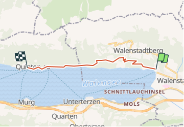
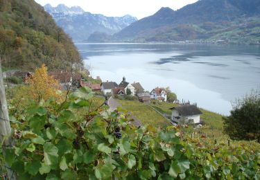
Tocht Andere activiteiten van 7,9 km beschikbaar op Sankt Gallen, Wahlkreis Sarganserland, Walenstadt. Deze tocht wordt voorgesteld door jschna.
Beschrijving
Mit der Bahn auf den Chäserrugg - wundeerbare Aussicht ins Sarganserland und auf den Säntis (Steinbockkolonie) - der erste Teil ist etwas steil und steinig, dann aber leicht und gut zum Gehen bis zur Gamsalp, wo der Wirt - Dres Forrer die Gäste verwöhnt.
Plaatsbepaling
Opmerkingen
Wandeltochten in de omgeving
![Tocht Stappen Quarten - Höhenwanderung Maschgenkamm-Murgsee - Photo](https://media.geolcdn.com/t/375/260/ext.jpg?maxdim=2&url=https%3A%2F%2Fstatic1.geolcdn.com%2Fsiteimages%2Fupload%2Ffiles%2F1553511878bg_sport_marche.png)
![Stappen Stappen](https://static1.geolcdn.com/sitytour/trail-icons/101.png)
Stappen
![](/images/other/stat-length.png)
![](https://static1.geolcdn.com/siteimages/upload/files/16400158638029165_repeat_loop_refresh_sync_direction_icon.png)
![Tocht Te voet Walenstadt - Walenstadt - Pluder - Photo](https://media.geolcdn.com/t/375/260/f2f44868-cecd-4f43-90e0-8033a6707992.jpeg&format=jpg&maxdim=2)
![Te voet Te voet](https://static1.geolcdn.com/sitytour/trail-icons/100.png)
Te voet
![](/images/other/stat-length.png)
![](https://static1.geolcdn.com/siteimages/upload/files/16400158638029165_repeat_loop_refresh_sync_direction_icon.png)
![Tocht Te voet Walenstadt - Pluder - Bergheim Vadella - Photo](https://media.geolcdn.com/t/375/260/a41923a2-5a3b-4b8d-8a8a-9e4f6c4dbf8b.jpeg&format=jpg&maxdim=2)
![Te voet Te voet](https://static1.geolcdn.com/sitytour/trail-icons/100.png)
Te voet
![](/images/other/stat-length.png)
![](https://static1.geolcdn.com/siteimages/upload/files/16400158638029165_repeat_loop_refresh_sync_direction_icon.png)
![Tocht Te voet Flums - Bergheim Vadella - Bildbrugg - Photo](https://media.geolcdn.com/t/375/260/a41923a2-5a3b-4b8d-8a8a-9e4f6c4dbf8b.jpeg&format=jpg&maxdim=2)
![Te voet Te voet](https://static1.geolcdn.com/sitytour/trail-icons/100.png)
Te voet
![](/images/other/stat-length.png)
![](https://static1.geolcdn.com/siteimages/upload/files/16400158638029165_repeat_loop_refresh_sync_direction_icon.png)
![Tocht Te voet Walenstadt - Hochrugg - Tschingla - Photo](https://media.geolcdn.com/t/375/260/4e3e585d-dcea-4eee-82b3-d518025e1ba9.jpeg&format=jpg&maxdim=2)
![Te voet Te voet](https://static1.geolcdn.com/sitytour/trail-icons/100.png)
Te voet
![](/images/other/stat-length.png)
![](https://static1.geolcdn.com/siteimages/upload/files/16400158638029165_repeat_loop_refresh_sync_direction_icon.png)
![Tocht Te voet Walenstadt - Hochrugg - Tschingla - Photo](https://media.geolcdn.com/t/375/260/53d53d06-e363-4149-ab8a-6920b0164781.jpeg&format=jpg&maxdim=2)
![Te voet Te voet](https://static1.geolcdn.com/sitytour/trail-icons/100.png)
Te voet
![](/images/other/stat-length.png)
![](https://static1.geolcdn.com/siteimages/upload/files/16400158638029165_repeat_loop_refresh_sync_direction_icon.png)
![Tocht Te voet Walenstadt - Walenstadtberg - Quinten - Photo](https://media.geolcdn.com/t/375/260/a4a8e10a-f071-4fc8-879d-94c4af5a5995.jpeg&format=jpg&maxdim=2)
![Te voet Te voet](https://static1.geolcdn.com/sitytour/trail-icons/100.png)
Te voet
![](/images/other/stat-length.png)
![](https://static1.geolcdn.com/siteimages/upload/files/16400158638029165_repeat_loop_refresh_sync_direction_icon.png)
![Tocht Te voet Quarten - Oberterzen - Hessenberg - Photo](https://media.geolcdn.com/t/375/260/635ff4d9-89f4-4d2f-8049-7fc584df7199.jpeg&format=jpg&maxdim=2)
![Te voet Te voet](https://static1.geolcdn.com/sitytour/trail-icons/100.png)
Te voet
![](/images/other/stat-length.png)
![](https://static1.geolcdn.com/siteimages/upload/files/16400158638029165_repeat_loop_refresh_sync_direction_icon.png)
![Tocht Te voet Quarten - Oberterzen - Heusee - Photo](https://media.geolcdn.com/t/375/260/9af17ee1-00f1-4340-9b59-dc260aba1df2.jpeg&format=jpg&maxdim=2)
![Te voet Te voet](https://static1.geolcdn.com/sitytour/trail-icons/100.png)
Te voet
![](/images/other/stat-length.png)
![](https://static1.geolcdn.com/siteimages/upload/files/16400158638029165_repeat_loop_refresh_sync_direction_icon.png)