![](/images/other/stat-length.png)
Tracé actuel: 23 NOV 2018 09:00
GilGry
Gebruiker
![Lengte](/images/other/stat-length.png)
Lengte
24 km
![Max. hoogte](https://static1.geolcdn.com/siteimages/upload/files/1508320355ic_sort_altitude_max_24dp.png)
Max. hoogte
1767 m
![Positief hoogteverschil](https://static1.geolcdn.com/siteimages/upload/files/1508320355ic_sort_den_pos_24dp.png)
Positief hoogteverschil
1234 m
![Km-Effort](/images/other/stat-length.png)
Km-Effort
40 km
![Min. hoogte](https://static1.geolcdn.com/siteimages/upload/files/1508320355ic_sort_altitude_min_24dp.png)
Min. hoogte
922 m
![Negatief hoogteverschil](https://static1.geolcdn.com/siteimages/upload/files/1508320355ic_sort_den_neg_24dp.png)
Negatief hoogteverschil
1234 m
![Boucle](https://static1.geolcdn.com/siteimages/upload/files/16400158638029165_repeat_loop_refresh_sync_direction_icon.png)
Boucle
Ja
Datum van aanmaak :
2018-11-23 21:26:21.787
Laatste wijziging :
2019-03-26 15:05:53.817
![Stappen](https://static1.geolcdn.com/sitytour/trail-icons/101.png)
8h13
Moeilijkheid : Zeer moeilijk
![Scan deze QR-code om de tocht te openen in de SityTrail-applicatie](https://capi.geolives.com/qq0zvz2zws4bq2lad0pu/sitytour/trails/2017690/qr.png?size=200)
Gratisgps-wandelapplicatie
Over ons
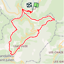
Tocht Stappen van 24 km beschikbaar op Auvergne-Rhône-Alpes, Cantal, Lavigerie. Deze tocht wordt voorgesteld door GilGry.
Beschrijving
Pas de Peyrol - Puy Mary - La brèche de Rolland - Col de cabre - Vallée de la Jouanne - Cascade du Luc - Mandailles - Puy Chavaroche pour le flanc - Pas de Peyrol.
Météo pourrie Moyen du parcours - Tracé modifié en s détournant de la crête du Puy Chavaroche
Plaatsbepaling
Land:
France
Regio :
Auvergne-Rhône-Alpes
Departement/Provincie :
Cantal
Gemeente :
Lavigerie
Locatie:
Unknown
Vertrek:(Dec)
Vertrek:(UTM)
475333 ; 4995486 (31T) N.
Opmerkingen
Wandeltochten in de omgeving
![Tocht Stappen Le Falgoux - Franconèche- Gr400-chemin des Italiens bis - Photo](https://media.geolcdn.com/t/375/260/1a65c1b3-73bb-45c2-bd6a-e33e2bc56ad3.jpg&format=jpg&maxdim=2)
![Stappen Stappen](https://static1.geolcdn.com/sitytour/trail-icons/101.png)
Franconèche- Gr400-chemin des Italiens bis
Stappen
Zeer moeilijk
(1)
Le Falgoux,
Auvergne-Rhône-Alpes,
Cantal,
France
![](/images/other/stat-length.png)
18,8 km | 28 km-effort
6h 46min
![](https://static1.geolcdn.com/siteimages/upload/files/16400158638029165_repeat_loop_refresh_sync_direction_icon.png)
Ja
![Tocht Stappen Lavigerie - Le Puy de Peyre Arse depuis la Gravière - Photo](https://media.geolcdn.com/t/375/260/ext.jpg?maxdim=2&url=https%3A%2F%2Fservices.sitytrail.com%2FGeolivesWS%2FDownloadMedia.ashx%3FTrailID%3D172317%26Media%3D13640_5.jpg)
![Stappen Stappen](https://static1.geolcdn.com/sitytour/trail-icons/101.png)
Le Puy de Peyre Arse depuis la Gravière
Stappen
Moeilijk
(2)
Lavigerie,
Auvergne-Rhône-Alpes,
Cantal,
France
![](/images/other/stat-length.png)
11,2 km | 21 km-effort
4h 0min
![](https://static1.geolcdn.com/siteimages/upload/files/16400158638029165_repeat_loop_refresh_sync_direction_icon.png)
Ja
![Tocht Stappen Laveissière - Les crêtes du Cantal - Le Lioran - Photo](https://media.geolcdn.com/t/375/260/ext.jpg?maxdim=2&url=https%3A%2F%2Fservices.sitytrail.com%2FGeolivesWS%2FDownloadMedia.ashx%3FTrailID%3D106122%26Media%3D10357_2.jpg)
![Stappen Stappen](https://static1.geolcdn.com/sitytour/trail-icons/101.png)
Les crêtes du Cantal - Le Lioran
Stappen
Moeilijk
(4)
Laveissière,
Auvergne-Rhône-Alpes,
Cantal,
France
![](/images/other/stat-length.png)
28 km | 51 km-effort
7h 30min
![](https://static1.geolcdn.com/siteimages/upload/files/16400158638029165_repeat_loop_refresh_sync_direction_icon.png)
Ja
![Tocht Stappen Mandailles-Saint-Julien - L'Elancèze - Photo](https://media.geolcdn.com/t/375/260/ext.jpg?maxdim=2&url=https%3A%2F%2Fservices.sitytrail.com%2FGeolivesWS%2FDownloadMedia.ashx%3FTrailID%3D103726%26Media%3D6387_2.jpg)
![Stappen Stappen](https://static1.geolcdn.com/sitytour/trail-icons/101.png)
L'Elancèze
Stappen
Moeilijk
(1)
Mandailles-Saint-Julien,
Auvergne-Rhône-Alpes,
Cantal,
France
![](/images/other/stat-length.png)
12,8 km | 24 km-effort
5h 0min
![](https://static1.geolcdn.com/siteimages/upload/files/16400158638029165_repeat_loop_refresh_sync_direction_icon.png)
Ja
![Tocht Stappen Laveissière - le Peyre Arse - Le Lioran - Photo](https://media.geolcdn.com/t/375/260/ext.jpg?maxdim=2&url=https%3A%2F%2Fservices.sitytrail.com%2FGeolivesWS%2FDownloadMedia.ashx%3FTrailID%3D103642%26Media%3D6060_2.jpg)
![Stappen Stappen](https://static1.geolcdn.com/sitytour/trail-icons/101.png)
le Peyre Arse - Le Lioran
Stappen
Moeilijk
(1)
Laveissière,
Auvergne-Rhône-Alpes,
Cantal,
France
![](/images/other/stat-length.png)
11,2 km | 19,4 km-effort
4h 0min
![](https://static1.geolcdn.com/siteimages/upload/files/16400158638029165_repeat_loop_refresh_sync_direction_icon.png)
Neen
![Tocht Stappen Laveissière - Lioran 2023-08-18 Col de Rombière Col du Pertus A/R - Photo](https://media.geolcdn.com/t/375/260/ext.jpg?maxdim=2&url=https%3A%2F%2Fstatic1.geolcdn.com%2Fsiteimages%2Fupload%2Ffiles%2F1553511878bg_sport_marche.png)
![Stappen Stappen](https://static1.geolcdn.com/sitytour/trail-icons/101.png)
Lioran 2023-08-18 Col de Rombière Col du Pertus A/R
Stappen
Gemakkelijk
(1)
Laveissière,
Auvergne-Rhône-Alpes,
Cantal,
France
![](/images/other/stat-length.png)
12,5 km | 18,8 km-effort
4h 14min
![](https://static1.geolcdn.com/siteimages/upload/files/16400158638029165_repeat_loop_refresh_sync_direction_icon.png)
Ja
![Tocht Stappen Laveissière - Lioran 2023-08-11 Col du Pertus - Photo](https://media.geolcdn.com/t/375/260/ext.jpg?maxdim=2&url=https%3A%2F%2Fstatic1.geolcdn.com%2Fsiteimages%2Fupload%2Ffiles%2F1553511878bg_sport_marche.png)
![Stappen Stappen](https://static1.geolcdn.com/sitytour/trail-icons/101.png)
Lioran 2023-08-11 Col du Pertus
Stappen
Medium
(1)
Laveissière,
Auvergne-Rhône-Alpes,
Cantal,
France
![](/images/other/stat-length.png)
17,3 km | 25 km-effort
2h 57min
![](https://static1.geolcdn.com/siteimages/upload/files/16400158638029165_repeat_loop_refresh_sync_direction_icon.png)
Ja
![Tocht Stappen Laveissière - Lioran 2023-08-09 Puy de Seycheuse - Photo](https://media.geolcdn.com/t/375/260/ext.jpg?maxdim=2&url=https%3A%2F%2Fstatic1.geolcdn.com%2Fsiteimages%2Fupload%2Ffiles%2F1553511878bg_sport_marche.png)
![Stappen Stappen](https://static1.geolcdn.com/sitytour/trail-icons/101.png)
Lioran 2023-08-09 Puy de Seycheuse
Stappen
Zeer moeilijk
(1)
Laveissière,
Auvergne-Rhône-Alpes,
Cantal,
France
![](/images/other/stat-length.png)
13,9 km | 23 km-effort
5h 20min
![](https://static1.geolcdn.com/siteimages/upload/files/16400158638029165_repeat_loop_refresh_sync_direction_icon.png)
Ja
![Tocht Trail Laveissière - Puy de Peyre Arse/ Puy Bataillouse / Téton de Vénus et Rocher du bec de l'aigle - Photo](https://media.geolcdn.com/t/375/260/2efbec1e-0f56-4871-abca-4b6cd09b30d9.jpg&format=jpg&maxdim=2)
![Trail Trail](https://static1.geolcdn.com/sitytour/trail-icons/104.png)
Puy de Peyre Arse/ Puy Bataillouse / Téton de Vénus et Rocher du bec de l'aigle
Trail
Medium
Laveissière,
Auvergne-Rhône-Alpes,
Cantal,
France
![](/images/other/stat-length.png)
12,8 km | 25 km-effort
3h 4min
![](https://static1.geolcdn.com/siteimages/upload/files/16400158638029165_repeat_loop_refresh_sync_direction_icon.png)
Ja