![](/images/other/stat-length.png)
![Tocht Stappen Niaux - Niaux - Photo](https://media.geolcdn.com/t/1900/400/204f7a14-8f48-445f-8259-da3afe3dc7c2.jpg&format=pjpeg&maxdim=2)
Niaux
c.chehere
Gebruiker
![Lengte](/images/other/stat-length.png)
![Max. hoogte](https://static1.geolcdn.com/siteimages/upload/files/1508320355ic_sort_altitude_max_24dp.png)
![Positief hoogteverschil](https://static1.geolcdn.com/siteimages/upload/files/1508320355ic_sort_den_pos_24dp.png)
![Km-Effort](/images/other/stat-length.png)
![Min. hoogte](https://static1.geolcdn.com/siteimages/upload/files/1508320355ic_sort_altitude_min_24dp.png)
![Negatief hoogteverschil](https://static1.geolcdn.com/siteimages/upload/files/1508320355ic_sort_den_neg_24dp.png)
![Boucle](https://static1.geolcdn.com/siteimages/upload/files/16400158638029165_repeat_loop_refresh_sync_direction_icon.png)
![Stappen](https://static1.geolcdn.com/sitytour/trail-icons/101.png)
3h20
Moeilijkheid : Gemakkelijk
![Scan deze QR-code om de tocht te openen in de SityTrail-applicatie](https://capi.geolives.com/qq0zvz2zws4bq2lad0pu/sitytour/trails/2012965/qr.png?size=200)
Gratisgps-wandelapplicatie
Over ons
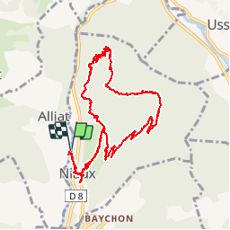
Tocht Stappen van 12,2 km beschikbaar op Occitanië, Ariège, Niaux. Deze tocht wordt voorgesteld door c.chehere.
Beschrijving
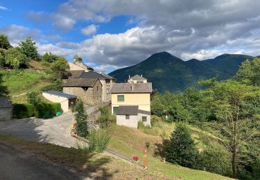
Parking près de la mairie
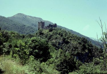
Monter par la route d'accès à la grotte de Niaux, prendre une piste forestière en direction de Arbiech. monter jusqu'au hameau et continuer par un très bon sentier bien tracé.
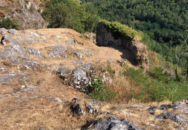
Déboucher sur l'entrée de la grotte de Niaux.
Redescendre par la route jusqu'au parking
Plaatsbepaling
Opmerkingen
Wandeltochten in de omgeving
![Tocht Stappen Gourbit - 04/06/2014 Rando Etang d'Artax - Photo](https://media.geolcdn.com/t/375/260/ext.jpg?maxdim=2&url=https%3A%2F%2Fservices.sitytrail.com%2FGeolivesWS%2FDownloadMedia.ashx%3FTrailID%3D308062%26Media%3D20140601132627.jpg)
![Stappen Stappen](https://static1.geolcdn.com/sitytour/trail-icons/101.png)
Stappen
![](/images/other/stat-length.png)
![](https://static1.geolcdn.com/siteimages/upload/files/16400158638029165_repeat_loop_refresh_sync_direction_icon.png)
![Tocht Stappen Tarascon-sur-Ariège - De Tarascon sur Ariège aux Cabannes - Photo](https://media.geolcdn.com/t/375/260/f4cff186-aaf1-4f11-94ae-b0b696c000be.jpg&format=jpg&maxdim=2)
![Stappen Stappen](https://static1.geolcdn.com/sitytour/trail-icons/101.png)
Stappen
![](/images/other/stat-length.png)
![](https://static1.geolcdn.com/siteimages/upload/files/16400158638029165_repeat_loop_refresh_sync_direction_icon.png)
![Tocht Stappen Tarascon-sur-Ariège - Tour de la pique de Tarrascon - Photo](https://media.geolcdn.com/t/375/260/d56397d2-9f78-431f-b676-33a1b154ea61.jpg&format=jpg&maxdim=2)
![Stappen Stappen](https://static1.geolcdn.com/sitytour/trail-icons/101.png)
Stappen
![](/images/other/stat-length.png)
![](https://static1.geolcdn.com/siteimages/upload/files/16400158638029165_repeat_loop_refresh_sync_direction_icon.png)
![Tocht Elektrische fiets Niaux - Niaux - Photo](https://media.geolcdn.com/t/375/260/2925b5db-f18d-4157-bbef-94a57335fc75.jpg&format=jpg&maxdim=2)
![Elektrische fiets Elektrische fiets](https://static1.geolcdn.com/sitytour/trail-icons/205.png)
Elektrische fiets
![](/images/other/stat-length.png)
![](https://static1.geolcdn.com/siteimages/upload/files/16400158638029165_repeat_loop_refresh_sync_direction_icon.png)
![Tocht Elektrische fiets Niaux - Château Miglos - Photo](https://media.geolcdn.com/t/375/260/8bba2701-86a9-409d-bc1b-998f1da97a1d.jpg&format=jpg&maxdim=2)
![Elektrische fiets Elektrische fiets](https://static1.geolcdn.com/sitytour/trail-icons/205.png)
Elektrische fiets
![](/images/other/stat-length.png)
![](https://static1.geolcdn.com/siteimages/upload/files/16400158638029165_repeat_loop_refresh_sync_direction_icon.png)
![Tocht Te voet Lapège - Lapège et Pladetis - Photo](https://media.geolcdn.com/t/375/260/acf32a31-72a6-4e31-a909-32a8fa5a01b2.jpeg&format=jpg&maxdim=2)
![Te voet Te voet](https://static1.geolcdn.com/sitytour/trail-icons/100.png)
Te voet
![](/images/other/stat-length.png)
![](https://static1.geolcdn.com/siteimages/upload/files/16400158638029165_repeat_loop_refresh_sync_direction_icon.png)
![Tocht Te voet Arnave - Le Tour de la Pique - Photo](https://media.geolcdn.com/t/375/260/f87f00e3-985f-4433-a5d5-f942175ed428.jpeg&format=jpg&maxdim=2)
![Te voet Te voet](https://static1.geolcdn.com/sitytour/trail-icons/100.png)
Te voet
![](/images/other/stat-length.png)
![](https://static1.geolcdn.com/siteimages/upload/files/16400158638029165_repeat_loop_refresh_sync_direction_icon.png)
![Tocht Te voet Illier-et-Laramade - D'Illier à Lapège - Photo](https://media.geolcdn.com/t/375/260/467a3965-d36a-44de-94c6-d7883cfb171b.jpeg&format=jpg&maxdim=2)
![Te voet Te voet](https://static1.geolcdn.com/sitytour/trail-icons/100.png)
Te voet
![](/images/other/stat-length.png)
![](https://static1.geolcdn.com/siteimages/upload/files/16400158638029165_repeat_loop_refresh_sync_direction_icon.png)
![Tocht Te voet Gourbit - Étang d'Artax - Photo](https://media.geolcdn.com/t/375/260/b2f84de2-fa0a-4b97-b201-829b16672ace.jpeg&format=jpg&maxdim=2)
![Te voet Te voet](https://static1.geolcdn.com/sitytour/trail-icons/100.png)
Te voet
![](/images/other/stat-length.png)
![](https://static1.geolcdn.com/siteimages/upload/files/16400158638029165_repeat_loop_refresh_sync_direction_icon.png)