![](/images/other/stat-length.png)
Pradelle - Vallée de la Roanne
Philindy26
Gebruiker
![Lengte](/images/other/stat-length.png)
![Max. hoogte](https://static1.geolcdn.com/siteimages/upload/files/1508320355ic_sort_altitude_max_24dp.png)
![Positief hoogteverschil](https://static1.geolcdn.com/siteimages/upload/files/1508320355ic_sort_den_pos_24dp.png)
![Km-Effort](/images/other/stat-length.png)
![Min. hoogte](https://static1.geolcdn.com/siteimages/upload/files/1508320355ic_sort_altitude_min_24dp.png)
![Negatief hoogteverschil](https://static1.geolcdn.com/siteimages/upload/files/1508320355ic_sort_den_neg_24dp.png)
![Boucle](https://static1.geolcdn.com/siteimages/upload/files/16400158638029165_repeat_loop_refresh_sync_direction_icon.png)
![Stappen](https://static1.geolcdn.com/sitytour/trail-icons/101.png)
4h00
Moeilijkheid : Medium
![Scan deze QR-code om de tocht te openen in de SityTrail-applicatie](https://capi.geolives.com/qq0zvz2zws4bq2lad0pu/sitytour/trails/2008267/qr.png?size=200)
Gratisgps-wandelapplicatie
Over ons
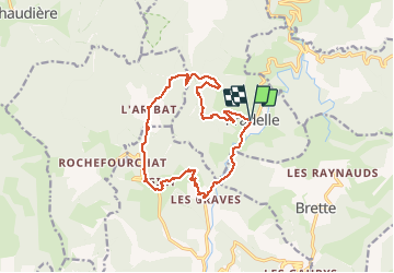
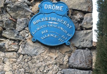
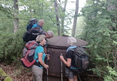
Tocht Stappen van 14,7 km beschikbaar op Auvergne-Rhône-Alpes, Drôme, Pradelle. Deze tocht wordt voorgesteld door Philindy26.
Beschrijving
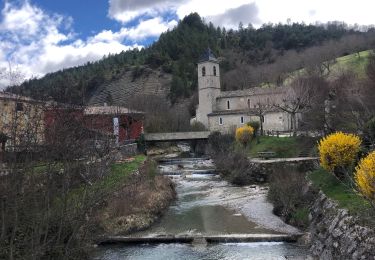
Départ de Pradelle, vallée de la Roanne (503 m)...
Géolocalisation (Google Maps) : https://goo.gl/maps/o1psbN4dsXJVLkxQ7 .
Prendre la direction des Graves (540 m) en suivant la route départementale n° 135 au sud…
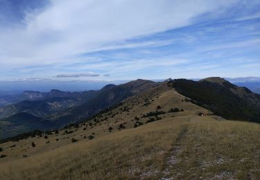
Montée par les Terrot (575 m), Giry (711 m), les Chauvins (655 m), l'Aribat (794 m) et le col de Trépalon (986 m).
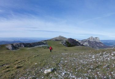
Descente sur Pradelle par le Ribal (866 m) et le Fay (Ruines) (750 m).
Plaatsbepaling
Opmerkingen
Wandeltochten in de omgeving
![Tocht Stappen Saint-Nazaire-le-Désert - 26 st Nazaire le desert - Photo](https://media.geolcdn.com/t/375/260/800f793b-c8e6-438c-bf52-c0a833bbf3e1.jpg&format=jpg&maxdim=2)
![Stappen Stappen](https://static1.geolcdn.com/sitytour/trail-icons/101.png)
Stappen
![](/images/other/stat-length.png)
![](https://static1.geolcdn.com/siteimages/upload/files/16400158638029165_repeat_loop_refresh_sync_direction_icon.png)
![Tocht Stappen Saint-Nazaire-le-Désert - Bergerie du Pradaux - Photo](https://media.geolcdn.com/t/375/260/ext.jpg?maxdim=2&url=https%3A%2F%2Fstatic1.geolcdn.com%2Fsiteimages%2Fupload%2Ffiles%2F1553511878bg_sport_marche.png)
![Stappen Stappen](https://static1.geolcdn.com/sitytour/trail-icons/101.png)
Stappen
![](/images/other/stat-length.png)
![](https://static1.geolcdn.com/siteimages/upload/files/16400158638029165_repeat_loop_refresh_sync_direction_icon.png)
![Tocht Stappen Rimon-et-Savel - balcons de la Roanne - Photo](https://media.geolcdn.com/t/375/260/6f529a2b-52ed-4864-b6b1-e2b0e3236399.jpg&format=jpg&maxdim=2)
![Stappen Stappen](https://static1.geolcdn.com/sitytour/trail-icons/101.png)
Stappen
![](/images/other/stat-length.png)
![](https://static1.geolcdn.com/siteimages/upload/files/16400158638029165_repeat_loop_refresh_sync_direction_icon.png)
![Tocht Stappen Rochefourchat - Serre Délégué depuis Rochefourchat 15 10 23 - Photo](https://media.geolcdn.com/t/375/260/dd32defb-f16e-4dda-98b5-10da95afa891.jpg&format=jpg&maxdim=2)
![Stappen Stappen](https://static1.geolcdn.com/sitytour/trail-icons/101.png)
Stappen
![](/images/other/stat-length.png)
![](https://static1.geolcdn.com/siteimages/upload/files/16400158638029165_repeat_loop_refresh_sync_direction_icon.png)
![Tocht Stappen Saint-Nazaire-le-Désert - Saint Nazaire le Désert - Photo](https://media.geolcdn.com/t/375/260/727e7242-c051-4080-9ece-fd964be15596.jpg&format=jpg&maxdim=2)
![Stappen Stappen](https://static1.geolcdn.com/sitytour/trail-icons/101.png)
Stappen
![](/images/other/stat-length.png)
![](https://static1.geolcdn.com/siteimages/upload/files/16400158638029165_repeat_loop_refresh_sync_direction_icon.png)
![Tocht Stappen Rochefourchat - Grand Delmas depuis Rochefourchat - Photo](https://media.geolcdn.com/t/375/260/d54b38a2-4988-4640-bf17-e0e6b4ff0960.jpg&format=jpg&maxdim=2)
![Stappen Stappen](https://static1.geolcdn.com/sitytour/trail-icons/101.png)
Stappen
![](/images/other/stat-length.png)
![](https://static1.geolcdn.com/siteimages/upload/files/16400158638029165_repeat_loop_refresh_sync_direction_icon.png)
![Tocht Stappen Saint-Nazaire-le-Désert - St Nazaire le Désert Bergerie des Pradaux - Photo](https://media.geolcdn.com/t/375/260/6e1323bf-526c-4599-aac0-2d5d88ff4402.jpg&format=jpg&maxdim=2)
![Stappen Stappen](https://static1.geolcdn.com/sitytour/trail-icons/101.png)
Stappen
![](/images/other/stat-length.png)
![](https://static1.geolcdn.com/siteimages/upload/files/16400158638029165_repeat_loop_refresh_sync_direction_icon.png)
![Tocht Stappen Rochefourchat - Rochefourchat (ASPTT) - Photo](https://media.geolcdn.com/t/375/260/1fdac6b0-e9dc-4a61-aa39-771c68602c4b.jpg&format=jpg&maxdim=2)
![Stappen Stappen](https://static1.geolcdn.com/sitytour/trail-icons/101.png)
Stappen
![](/images/other/stat-length.png)
![](https://static1.geolcdn.com/siteimages/upload/files/16400158638029165_repeat_loop_refresh_sync_direction_icon.png)
![Tocht Stappen Aucelon - la montagne d Aucelon - Photo](https://media.geolcdn.com/t/375/260/418d345f-bb1e-4446-b000-4d78372a3cd9.jpg&format=jpg&maxdim=2)
![Stappen Stappen](https://static1.geolcdn.com/sitytour/trail-icons/101.png)
Stappen
![](/images/other/stat-length.png)
![](https://static1.geolcdn.com/siteimages/upload/files/16400158638029165_repeat_loop_refresh_sync_direction_icon.png)