![](/images/other/stat-length.png)
![Tocht Stappen Jouy-le-Moutier - SityTrail - GRP CV-IDF - Photo](https://media.geolcdn.com/t/1900/400/99d2c596-03dc-4c70-b7bc-02f8526118d4.jpg&format=pjpeg&maxdim=2)
SityTrail - GRP CV-IDF
clalaur
Gebruiker
![Lengte](/images/other/stat-length.png)
Lengte
18,2 km
![Max. hoogte](https://static1.geolcdn.com/siteimages/upload/files/1508320355ic_sort_altitude_max_24dp.png)
Max. hoogte
135 m
![Positief hoogteverschil](https://static1.geolcdn.com/siteimages/upload/files/1508320355ic_sort_den_pos_24dp.png)
Positief hoogteverschil
162 m
![Km-Effort](/images/other/stat-length.png)
Km-Effort
21 km
![Min. hoogte](https://static1.geolcdn.com/siteimages/upload/files/1508320355ic_sort_altitude_min_24dp.png)
Min. hoogte
13 m
![Negatief hoogteverschil](https://static1.geolcdn.com/siteimages/upload/files/1508320355ic_sort_den_neg_24dp.png)
Negatief hoogteverschil
211 m
![Boucle](https://static1.geolcdn.com/siteimages/upload/files/16400158638029165_repeat_loop_refresh_sync_direction_icon.png)
Boucle
Neen
Datum van aanmaak :
2018-06-08 15:54:44.405
Laatste wijziging :
2019-04-06 15:12:04.565
![Stappen](https://static1.geolcdn.com/sitytour/trail-icons/101.png)
4h15
Moeilijkheid : Gemakkelijk
![Scan deze QR-code om de tocht te openen in de SityTrail-applicatie](https://capi.geolives.com/qq0zvz2zws4bq2lad0pu/sitytour/trails/2002263/qr.png?size=200)
Gratisgps-wandelapplicatie
Over ons
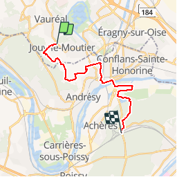
Tocht Stappen van 18,2 km beschikbaar op Île-de-France, Val-d'Oise, Jouy-le-Moutier. Deze tocht wordt voorgesteld door clalaur.
Beschrijving
Ceinture verte de l'Ile de France. Etape 13 sur 16 - De Jouy-le-Moutier (BUS STIVO 34 - Les Tremblays) a la gare d'Acheres - Grand-Cormier (J RER A)
Plaatsbepaling
Land:
France
Regio :
Île-de-France
Departement/Provincie :
Val-d'Oise
Gemeente :
Jouy-le-Moutier
Locatie:
Unknown
Vertrek:(Dec)
Vertrek:(UTM)
428881 ; 5429418 (31U) N.
Opmerkingen
Wandeltochten in de omgeving
![Tocht Te voet Conflans-Sainte-Honorine - Version définitive Conflans 7 janvier - Photo](https://media.geolcdn.com/t/375/260/2f5b666a-1419-402d-9c3e-8de986f24ebf.jpg&format=jpg&maxdim=2)
![Te voet Te voet](https://static1.geolcdn.com/sitytour/trail-icons/100.png)
Version définitive Conflans 7 janvier
Te voet
Medium
(1)
Conflans-Sainte-Honorine,
Île-de-France,
Yvelines,
France
![](/images/other/stat-length.png)
23 km | 28 km-effort
6h 22min
![](https://static1.geolcdn.com/siteimages/upload/files/16400158638029165_repeat_loop_refresh_sync_direction_icon.png)
Neen
![Tocht Stappen Pontoise - GRP CV-IDF 2023 - Photo](https://media.geolcdn.com/t/375/260/5cecfad9-3425-44be-8077-e3aed6f072e1.jpg&format=jpg&maxdim=2)
![Stappen Stappen](https://static1.geolcdn.com/sitytour/trail-icons/101.png)
GRP CV-IDF 2023
Stappen
Moeilijk
(1)
Pontoise,
Île-de-France,
Val-d'Oise,
France
![](/images/other/stat-length.png)
15,3 km | 18,6 km-effort
4h 13min
![](https://static1.geolcdn.com/siteimages/upload/files/16400158638029165_repeat_loop_refresh_sync_direction_icon.png)
Neen
![Tocht Stappen Jouy-le-Moutier - GRP CV-IDF 2023 - Photo](https://media.geolcdn.com/t/375/260/6d7dbb85-8194-44c4-a991-493315d817a9.jpg&format=jpg&maxdim=2)
![Stappen Stappen](https://static1.geolcdn.com/sitytour/trail-icons/101.png)
GRP CV-IDF 2023
Stappen
Moeilijk
(1)
Jouy-le-Moutier,
Île-de-France,
Val-d'Oise,
France
![](/images/other/stat-length.png)
15,6 km | 18 km-effort
4h 4min
![](https://static1.geolcdn.com/siteimages/upload/files/16400158638029165_repeat_loop_refresh_sync_direction_icon.png)
Neen
![Tocht Lopen Cergy - Les Bords de l'Oise et la Passerelle de l'Axe Majeur - Port Cergy - Photo](https://media.geolcdn.com/t/375/260/ext.jpg?maxdim=2&url=https%3A%2F%2Fservices.sitytrail.com%2FGeolivesWS%2FDownloadMedia.ashx%3FTrailID%3D118750%26Media%3D12946_6.jpg)
![Lopen Lopen](https://static1.geolcdn.com/sitytour/trail-icons/103.png)
Les Bords de l'Oise et la Passerelle de l'Axe Majeur - Port Cergy
Lopen
Gemakkelijk
(1)
Cergy,
Île-de-France,
Val-d'Oise,
France
![](/images/other/stat-length.png)
5,2 km | 5,8 km-effort
30min
![](https://static1.geolcdn.com/siteimages/upload/files/16400158638029165_repeat_loop_refresh_sync_direction_icon.png)
Ja
![Tocht Te voet Cergy - LES BALADES DE L’ÉTÉ # 9 / DE L’AXE MAJEUR À PORT CERGY - Photo](https://media.geolcdn.com/t/375/260/0abd8c0c-1f20-444a-8fa9-27c91da3cbd0.jpeg&format=jpg&maxdim=2)
![Te voet Te voet](https://static1.geolcdn.com/sitytour/trail-icons/100.png)
LES BALADES DE L’ÉTÉ # 9 / DE L’AXE MAJEUR À PORT CERGY
Te voet
Heel gemakkelijk
(1)
Cergy,
Île-de-France,
Val-d'Oise,
France
![](/images/other/stat-length.png)
6 km | 7,4 km-effort
1h 45min
![](https://static1.geolcdn.com/siteimages/upload/files/16400158638029165_repeat_loop_refresh_sync_direction_icon.png)
Ja
![Tocht Te voet Conflans-Sainte-Honorine - Conflans fin d'oise - Andresy - La Frette - Photo](https://media.geolcdn.com/t/375/260/43572d18-a869-49dd-98f4-125a083ecdd2.jpg&format=jpg&maxdim=2)
![Te voet Te voet](https://static1.geolcdn.com/sitytour/trail-icons/100.png)
Conflans fin d'oise - Andresy - La Frette
Te voet
Medium
Conflans-Sainte-Honorine,
Île-de-France,
Yvelines,
France
![](/images/other/stat-length.png)
22 km | 27 km-effort
6h 14min
![](https://static1.geolcdn.com/siteimages/upload/files/16400158638029165_repeat_loop_refresh_sync_direction_icon.png)
Neen
![Tocht Stappen Triel-sur-Seine - le tour du Grand Paris via le GR1 - Etape 3 Triels sur Seine - Santeuil - Photo](https://media.geolcdn.com/t/375/260/3cb9cfcf-d13a-42e8-9e23-a6dedbb9762a.jpg&format=jpg&maxdim=2)
![Stappen Stappen](https://static1.geolcdn.com/sitytour/trail-icons/101.png)
le tour du Grand Paris via le GR1 - Etape 3 Triels sur Seine - Santeuil
Stappen
Medium
Triel-sur-Seine,
Île-de-France,
Yvelines,
France
![](/images/other/stat-length.png)
31 km | 38 km-effort
6h 27min
![](https://static1.geolcdn.com/siteimages/upload/files/16400158638029165_repeat_loop_refresh_sync_direction_icon.png)
Neen
![Tocht Te voet Cergy - Le Fil d'Ariane - Photo](https://media.geolcdn.com/t/375/260/99555ae7-7473-4890-8cc1-181c61a69de2.jpeg&format=jpg&maxdim=2)
![Te voet Te voet](https://static1.geolcdn.com/sitytour/trail-icons/100.png)
Le Fil d'Ariane
Te voet
Gemakkelijk
Cergy,
Île-de-France,
Val-d'Oise,
France
![](/images/other/stat-length.png)
3,2 km | 3,7 km-effort
50min
![](https://static1.geolcdn.com/siteimages/upload/files/16400158638029165_repeat_loop_refresh_sync_direction_icon.png)
Neen
![Tocht Mountainbike Vernouillet - Activity - Photo](https://media.geolcdn.com/t/375/260/ext.jpg?maxdim=2&url=https%3A%2F%2Fstatic1.geolcdn.com%2Fsiteimages%2Fupload%2Ffiles%2F1524743154velo.jpg)
![Mountainbike Mountainbike](https://static1.geolcdn.com/sitytour/trail-icons/202.png)
Activity
Mountainbike
Zeer moeilijk
(1)
Vernouillet,
Île-de-France,
Yvelines,
France
![](/images/other/stat-length.png)
44 km | 51 km-effort
3h 33min
![](https://static1.geolcdn.com/siteimages/upload/files/16400158638029165_repeat_loop_refresh_sync_direction_icon.png)
Ja