Tocht Mountainbike Lévigny - baralbike LEVIGNY 2013 - Photo

baralbike LEVIGNY 2013

 Tollard
Tollard

Gebruiker

© OpenStreetMap contributors
Lengte
Lengte
59 km
Max. hoogte
Max. hoogte
334 m
Positief hoogteverschil
1005 m
Km-Effort
Km-Effort  
73 km
Min. hoogte
Min. hoogte
157 m
Negatief hoogteverschil
1007 m
Boucle
Boucle
Ja
Datum van aanmaak :
2014-12-10 00:00:00.0
Laatste wijziging :
2014-12-10 00:00:00.0

(0 Bericht)

Mountainbike
Mountainbike
4h40
Moeilijkheid : Zeer moeilijk

Scan deze QR-code om de tocht te openen in de SityTrail-applicatie

Gratisgps-wandelapplicatie

Logo SityTrail SityTrail

IGN / Geografische instituten

SityTrail uit de App Store downloaden SityTrail uit Google Play downloaden

Logo SityTrail SityTrail World

De wereld gaat voor u open

SityTrail uit de App Store downloaden SityTrail uit Google Play downloaden SityTrail op Huawei AppGallery downloaden

Over ons

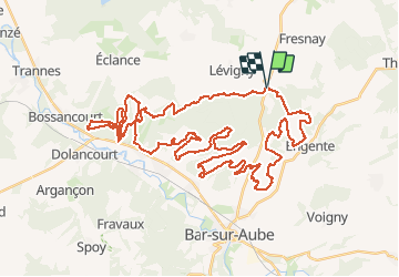
Tocht Mountainbike van 59 km beschikbaar op Grand Est, Aube, Lévigny. Deze tocht wordt voorgesteld door Tollard.

Hoogteprofiel

Plaatsbepaling

Land:
France
Regio :
Grand Est
Departement/Provincie :
Aube
Gemeente :
Lévigny
Locatie:
Unknown
Vertrek:(Dec)
Vertrek:(UTM)
628319 ; 5350397 (31U) N.

Wandeltochten in de omgeving

Tocht Te voet Colombé-le-Sec - Circuit Gaston Cheq - Photo
Te voet
PRO

Te voet

Medium
Colombé-le-Sec, Grand Est, Aube, France
20 km | 26 km-effort
5h 53min
Neen
Tocht Mountainbike Arrentières - quad arrentiere - Photo
Mountainbike
stlvain

Mountainbike

Zeer moeilijk
Arrentières, Grand Est, Aube, France
69 km | 86 km-effort
141h 8min
Ja
Tocht Andere activiteiten Colombé-le-Sec - colombé le sec 20 km - Photo
Andere activiteiten
GUIDE
rvapeldo

Andere activiteiten

Gemakkelijk
Colombé-le-Sec, Grand Est, Aube, France
22 km | 27 km-effort
6h 42min
Ja
Tocht Quad Arrentières - arentieres - Photo
Quad
powerdu21

Quad

Heel gemakkelijk
Arrentières, Grand Est, Aube, France
100 km | 128 km-effort
8h 20min
Ja


Sluiten
Mijn abonnementen