![](/images/other/stat-length.png)
![Tocht Andere activiteiten Sempach - Anfahrt ab Autobahnausfahrt Sempach - Photo](https://media.geolcdn.com/t/1900/400/ext.pjpeg?maxdim=2&url=https%3A%2F%2Fstatic1.geolcdn.com%2Fsiteimages%2Fupload%2Ffiles%2F1545311037marcheuse_200dpi.jpg)
Anfahrt ab Autobahnausfahrt Sempach
fritz
Gebruiker
![Lengte](/images/other/stat-length.png)
![Max. hoogte](https://static1.geolcdn.com/siteimages/upload/files/1508320355ic_sort_altitude_max_24dp.png)
![Positief hoogteverschil](https://static1.geolcdn.com/siteimages/upload/files/1508320355ic_sort_den_pos_24dp.png)
![Km-Effort](/images/other/stat-length.png)
![Min. hoogte](https://static1.geolcdn.com/siteimages/upload/files/1508320355ic_sort_altitude_min_24dp.png)
![Negatief hoogteverschil](https://static1.geolcdn.com/siteimages/upload/files/1508320355ic_sort_den_neg_24dp.png)
![Boucle](https://static1.geolcdn.com/siteimages/upload/files/16400158638029165_repeat_loop_refresh_sync_direction_icon.png)
![Andere activiteiten](https://static1.geolcdn.com/sitytour/trail-icons/900.png)
--
Moeilijkheid : Onbekend
![Scan deze QR-code om de tocht te openen in de SityTrail-applicatie](https://capi.geolives.com/qq0zvz2zws4bq2lad0pu/sitytour/trails/19710/qr.png?size=200)
Gratisgps-wandelapplicatie
Over ons
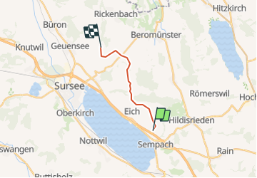
Tocht Andere activiteiten van 9,4 km beschikbaar op Luzern, Onbekend, Sempach. Deze tocht wordt voorgesteld door fritz.
Beschrijving
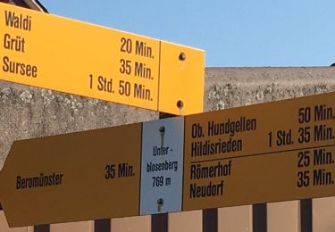
Die Anfahrt ist ab Sempach mit der rot gestrichelten Linie markiert. Sie fahren Richtung Vogelsang-Waldi-Rickenbach. ca. 1 km nach Waldi sehen Sie links die ehemaligen Käserei Holdern. Dort biegen Sie links ab und folgen den Holzwegweisern Richtung Diegenstal oder den kleinen Wegweisern "Bauer Fritz". Sie können auf Wunsch die Karte auch näher zoomen.
Plaatsbepaling
Opmerkingen
Wandeltochten in de omgeving
![Tocht Te voet Beromünster - Neudorf - Unter Blosenberg - Photo](https://media.geolcdn.com/t/375/260/a9e8306d-f111-4dfc-9c67-cc4e4df5163f.jpeg&format=jpg&maxdim=2)
![Te voet Te voet](https://static1.geolcdn.com/sitytour/trail-icons/100.png)
Te voet
![](/images/other/stat-length.png)
![](https://static1.geolcdn.com/siteimages/upload/files/16400158638029165_repeat_loop_refresh_sync_direction_icon.png)
![Tocht Te voet Nottwil - Sempachersee-Moosweg - Photo](https://media.geolcdn.com/t/375/260/5b43a39d-2789-497e-af40-998ef39b5ba7.jpeg&format=jpg&maxdim=2)
![Te voet Te voet](https://static1.geolcdn.com/sitytour/trail-icons/100.png)
Te voet
![](/images/other/stat-length.png)
![](https://static1.geolcdn.com/siteimages/upload/files/16400158638029165_repeat_loop_refresh_sync_direction_icon.png)
![Tocht Te voet Römerswil - Hildisrieden - Römerswil - Photo](https://media.geolcdn.com/t/375/260/0a4147b2-cbff-44df-a56a-c1941275f40c.jpeg&format=jpg&maxdim=2)
![Te voet Te voet](https://static1.geolcdn.com/sitytour/trail-icons/100.png)
Te voet
![](/images/other/stat-length.png)
![](https://static1.geolcdn.com/siteimages/upload/files/16400158638029165_repeat_loop_refresh_sync_direction_icon.png)
![Tocht Te voet Beromünster - Morentaler Wald - Blosenberg - Photo](https://media.geolcdn.com/t/375/260/a9e8306d-f111-4dfc-9c67-cc4e4df5163f.jpeg&format=jpg&maxdim=2)
![Te voet Te voet](https://static1.geolcdn.com/sitytour/trail-icons/100.png)
Te voet
![](/images/other/stat-length.png)
![](https://static1.geolcdn.com/siteimages/upload/files/16400158638029165_repeat_loop_refresh_sync_direction_icon.png)
![Tocht Te voet Beromünster - Waldhaus - Älmeringen -Gormund - Photo](https://media.geolcdn.com/t/375/260/c9cebd51-7d26-4f59-8a42-112d0a21e44a.jpeg&format=jpg&maxdim=2)
![Te voet Te voet](https://static1.geolcdn.com/sitytour/trail-icons/100.png)
Te voet
![](/images/other/stat-length.png)
![](https://static1.geolcdn.com/siteimages/upload/files/16400158638029165_repeat_loop_refresh_sync_direction_icon.png)
![Tocht Te voet Neuenkirch - Adelwil - Bärtiswil - Photo](https://media.geolcdn.com/t/375/260/d286582e-e630-4410-99ae-955497ecf71b.jpeg&format=jpg&maxdim=2)
![Te voet Te voet](https://static1.geolcdn.com/sitytour/trail-icons/100.png)
Te voet
![](/images/other/stat-length.png)
![](https://static1.geolcdn.com/siteimages/upload/files/16400158638029165_repeat_loop_refresh_sync_direction_icon.png)
![Tocht Te voet Nottwil - Nottwil - Sempach (Vogelwarte) - Photo](https://media.geolcdn.com/t/375/260/06c2aee0-d9ed-4bae-a21f-a68a34b0e075.jpeg&format=jpg&maxdim=2)
![Te voet Te voet](https://static1.geolcdn.com/sitytour/trail-icons/100.png)
Te voet
![](/images/other/stat-length.png)
![](https://static1.geolcdn.com/siteimages/upload/files/16400158638029165_repeat_loop_refresh_sync_direction_icon.png)
![Tocht Te voet Schenkon - Schenkon - Eich - Photo](https://media.geolcdn.com/t/375/260/274c9e7b-5c2d-4d8b-8988-66feb5aa3fce.jpeg&format=jpg&maxdim=2)
![Te voet Te voet](https://static1.geolcdn.com/sitytour/trail-icons/100.png)
Te voet
![](/images/other/stat-length.png)
![](https://static1.geolcdn.com/siteimages/upload/files/16400158638029165_repeat_loop_refresh_sync_direction_icon.png)
![Tocht Te voet Neuenkirch - Niklaus Wolf Weg - Photo](https://media.geolcdn.com/t/375/260/566428a6-7061-4778-a877-ae993341de8d.jpeg&format=jpg&maxdim=2)
![Te voet Te voet](https://static1.geolcdn.com/sitytour/trail-icons/100.png)
Te voet
![](/images/other/stat-length.png)
![](https://static1.geolcdn.com/siteimages/upload/files/16400158638029165_repeat_loop_refresh_sync_direction_icon.png)