![](/images/other/stat-length.png)
![Tocht Andere activiteiten Samedan - GR / muottas muragl - segantinihütte - alp languard - Photo](https://media.geolcdn.com/t/1900/400/ext.pjpeg?maxdim=2&url=https%3A%2F%2Fstatic1.geolcdn.com%2Fsiteimages%2Fupload%2Ffiles%2F1545311037marcheuse_200dpi.jpg)
GR / muottas muragl - segantinihütte - alp languard
denisewanderige
Gebruiker
![Lengte](/images/other/stat-length.png)
Lengte
9,9 km
![Max. hoogte](https://static1.geolcdn.com/siteimages/upload/files/1508320355ic_sort_altitude_max_24dp.png)
Max. hoogte
2747 m
![Positief hoogteverschil](https://static1.geolcdn.com/siteimages/upload/files/1508320355ic_sort_den_pos_24dp.png)
Positief hoogteverschil
676 m
![Km-Effort](/images/other/stat-length.png)
Km-Effort
19,3 km
![Min. hoogte](https://static1.geolcdn.com/siteimages/upload/files/1508320355ic_sort_altitude_min_24dp.png)
Min. hoogte
2308 m
![Negatief hoogteverschil](https://static1.geolcdn.com/siteimages/upload/files/1508320355ic_sort_den_neg_24dp.png)
Negatief hoogteverschil
814 m
![Boucle](https://static1.geolcdn.com/siteimages/upload/files/16400158638029165_repeat_loop_refresh_sync_direction_icon.png)
Boucle
Neen
Datum van aanmaak :
2014-12-11 00:00:00.0
Laatste wijziging :
2014-12-11 00:00:00.0
![Andere activiteiten](https://static1.geolcdn.com/sitytour/trail-icons/900.png)
--
Moeilijkheid : Onbekend
![Scan deze QR-code om de tocht te openen in de SityTrail-applicatie](https://capi.geolives.com/qq0zvz2zws4bq2lad0pu/sitytour/trails/19498/qr.png?size=200)
Gratisgps-wandelapplicatie
Over ons
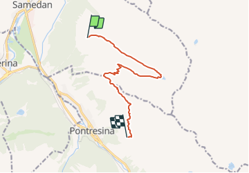
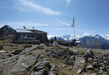
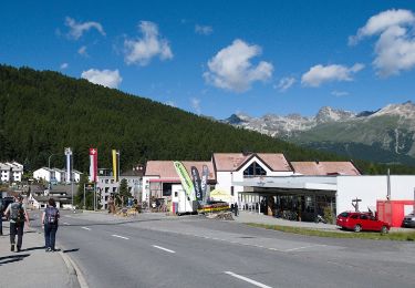
Tocht Andere activiteiten van 9,9 km beschikbaar op Graubünden, Maloja, Samedan. Deze tocht wordt voorgesteld door denisewanderige.
Beschrijving
Details (Wanderbeschrieb, Fotos, Dauer, Links, usw.) siehe unter:
http://www.wanderige.ch/wanderige_toure/2007/segantini/segantini.html
Plaatsbepaling
Land:
Switzerland
Regio :
Graubünden
Departement/Provincie :
Maloja
Gemeente :
Samedan
Locatie:
Unknown
Vertrek:(Dec)
Vertrek:(UTM)
569182 ; 5152403 (32T) N.
Opmerkingen
Wandeltochten in de omgeving
![Tocht Te voet Sankt Moritz - SEERUNDGANG - Photo](https://media.geolcdn.com/t/375/260/fb476387-3b2e-4236-b860-c8f411416028.jpeg&format=jpg&maxdim=2)
![Te voet Te voet](https://static1.geolcdn.com/sitytour/trail-icons/100.png)
SEERUNDGANG
Te voet
Gemakkelijk
Sankt Moritz,
Graubünden,
Maloja,
Switzerland
![](/images/other/stat-length.png)
4,3 km | 5,1 km-effort
1h 10min
![](https://static1.geolcdn.com/siteimages/upload/files/16400158638029165_repeat_loop_refresh_sync_direction_icon.png)
Ja
![Tocht Te voet Bever - Bever - Spinas (Alternativroute) - Photo](https://media.geolcdn.com/t/375/260/7e33e9bc-95dc-4fc4-81b2-c14c2c4df8b6.jpeg&format=jpg&maxdim=2)
![Te voet Te voet](https://static1.geolcdn.com/sitytour/trail-icons/100.png)
Bever - Spinas (Alternativroute)
Te voet
Gemakkelijk
Bever,
Graubünden,
Maloja,
Switzerland
![](/images/other/stat-length.png)
4,3 km | 6 km-effort
1h 22min
![](https://static1.geolcdn.com/siteimages/upload/files/16400158638029165_repeat_loop_refresh_sync_direction_icon.png)
Neen
![Tocht Te voet Bever - Spinas-Bever - Photo](https://media.geolcdn.com/t/375/260/7e33e9bc-95dc-4fc4-81b2-c14c2c4df8b6.jpeg&format=jpg&maxdim=2)
![Te voet Te voet](https://static1.geolcdn.com/sitytour/trail-icons/100.png)
Spinas-Bever
Te voet
Gemakkelijk
Bever,
Graubünden,
Maloja,
Switzerland
![](/images/other/stat-length.png)
4,2 km | 5,3 km-effort
1h 11min
![](https://static1.geolcdn.com/siteimages/upload/files/16400158638029165_repeat_loop_refresh_sync_direction_icon.png)
Neen
![Tocht Te voet Pontresina - Muottas Muragl - Unterer Schafberg - Photo](https://media.geolcdn.com/t/375/260/fdb48e21-1399-4e12-aef6-21c111ae9825.jpeg&format=jpg&maxdim=2)
![Te voet Te voet](https://static1.geolcdn.com/sitytour/trail-icons/100.png)
Muottas Muragl - Unterer Schafberg
Te voet
Gemakkelijk
Pontresina,
Graubünden,
Maloja,
Switzerland
![](/images/other/stat-length.png)
4,5 km | 7,3 km-effort
1h 39min
![](https://static1.geolcdn.com/siteimages/upload/files/16400158638029165_repeat_loop_refresh_sync_direction_icon.png)
Neen
![Tocht Te voet Samedan - Muottas Muragl - Chna. Segantini - Photo](https://media.geolcdn.com/t/375/260/d84cc500-2aaa-4cb6-8029-493b05a6f4f0.jpeg&format=jpg&maxdim=2)
![Te voet Te voet](https://static1.geolcdn.com/sitytour/trail-icons/100.png)
Muottas Muragl - Chna. Segantini
Te voet
Gemakkelijk
Samedan,
Graubünden,
Maloja,
Switzerland
![](/images/other/stat-length.png)
3,4 km | 5,8 km-effort
1h 18min
![](https://static1.geolcdn.com/siteimages/upload/files/16400158638029165_repeat_loop_refresh_sync_direction_icon.png)
Neen
![Tocht Te voet Pontresina - Puntraschigna - Roseg - Photo](https://media.geolcdn.com/t/375/260/228522e8-b30d-4ac8-8507-135e9cf1526f.jpeg&format=jpg&maxdim=2)
![Te voet Te voet](https://static1.geolcdn.com/sitytour/trail-icons/100.png)
Puntraschigna - Roseg
Te voet
Gemakkelijk
Pontresina,
Graubünden,
Maloja,
Switzerland
![](/images/other/stat-length.png)
6,7 km | 9,2 km-effort
2h 5min
![](https://static1.geolcdn.com/siteimages/upload/files/16400158638029165_repeat_loop_refresh_sync_direction_icon.png)
Neen
![Tocht Te voet Bever - Alp Spinas-Chamanna Jenatsch - Photo](https://media.geolcdn.com/t/375/260/7e33e9bc-95dc-4fc4-81b2-c14c2c4df8b6.jpeg&format=jpg&maxdim=2)
![Te voet Te voet](https://static1.geolcdn.com/sitytour/trail-icons/100.png)
Alp Spinas-Chamanna Jenatsch
Te voet
Medium
Bever,
Graubünden,
Maloja,
Switzerland
![](/images/other/stat-length.png)
12,1 km | 21 km-effort
4h 46min
![](https://static1.geolcdn.com/siteimages/upload/files/16400158638029165_repeat_loop_refresh_sync_direction_icon.png)
Neen
![Tocht Andere activiteiten Pontresina - y10_muottas_muragl - Photo](https://media.geolcdn.com/t/375/260/ext.jpg?maxdim=2&url=https%3A%2F%2Fstatic1.geolcdn.com%2Fsiteimages%2Fupload%2Ffiles%2F1545311037marcheuse_200dpi.jpg)
![Andere activiteiten Andere activiteiten](https://static1.geolcdn.com/sitytour/trail-icons/900.png)
y10_muottas_muragl
Andere activiteiten
Heel gemakkelijk
Pontresina,
Graubünden,
Maloja,
Switzerland
![](/images/other/stat-length.png)
11,7 km | 22 km-effort
5h 1min
![](https://static1.geolcdn.com/siteimages/upload/files/16400158638029165_repeat_loop_refresh_sync_direction_icon.png)
Neen
![Tocht Stappen Sankt Moritz - mtb04 - Photo](https://media.geolcdn.com/t/375/260/ext.jpg?maxdim=2&url=https%3A%2F%2Fstatic1.geolcdn.com%2Fsiteimages%2Fupload%2Ffiles%2F1553511878bg_sport_marche.png)
![Stappen Stappen](https://static1.geolcdn.com/sitytour/trail-icons/101.png)
mtb04
Stappen
Heel gemakkelijk
Sankt Moritz,
Graubünden,
Maloja,
Switzerland
![](/images/other/stat-length.png)
25 km | 39 km-effort
Onbekend
![](https://static1.geolcdn.com/siteimages/upload/files/16400158638029165_repeat_loop_refresh_sync_direction_icon.png)
Ja