![](/images/other/stat-length.png)
![Tocht Stappen Bech - Müllerthal Extra Trail C - Photo](https://media.geolcdn.com/t/1900/400/ext.pjpeg?maxdim=2&url=https%3A%2F%2Fstatic1.geolcdn.com%2Fsiteimages%2Fupload%2Ffiles%2F1553511878bg_sport_marche.png)
Müllerthal Extra Trail C
flip96
Gebruiker
![Lengte](/images/other/stat-length.png)
Lengte
9,9 km
![Max. hoogte](https://static1.geolcdn.com/siteimages/upload/files/1508320355ic_sort_altitude_max_24dp.png)
Max. hoogte
400 m
![Positief hoogteverschil](https://static1.geolcdn.com/siteimages/upload/files/1508320355ic_sort_den_pos_24dp.png)
Positief hoogteverschil
248 m
![Km-Effort](/images/other/stat-length.png)
Km-Effort
13,2 km
![Min. hoogte](https://static1.geolcdn.com/siteimages/upload/files/1508320355ic_sort_altitude_min_24dp.png)
Min. hoogte
304 m
![Negatief hoogteverschil](https://static1.geolcdn.com/siteimages/upload/files/1508320355ic_sort_den_neg_24dp.png)
Negatief hoogteverschil
247 m
![Boucle](https://static1.geolcdn.com/siteimages/upload/files/16400158638029165_repeat_loop_refresh_sync_direction_icon.png)
Boucle
Ja
Datum van aanmaak :
2014-12-10 00:00:00.0
Laatste wijziging :
2014-12-10 00:00:00.0
![Stappen](https://static1.geolcdn.com/sitytour/trail-icons/101.png)
2h50
Moeilijkheid : Gemakkelijk
![Scan deze QR-code om de tocht te openen in de SityTrail-applicatie](https://capi.geolives.com/qq0zvz2zws4bq2lad0pu/sitytour/trails/192153/qr.png?size=200)
Gratisgps-wandelapplicatie
Over ons
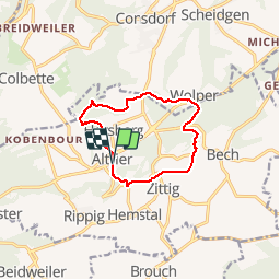
Tocht Stappen van 9,9 km beschikbaar op Onbekend, Canton Echternach, Bech. Deze tocht wordt voorgesteld door flip96.
Beschrijving
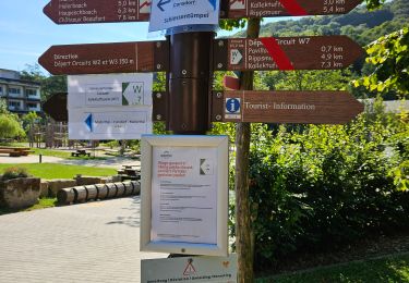
Müllerthal Extra Trail C 10km.
Gestart in Altrier waar parkeerplaats is aan kruising Op der Schanz met Heeschbregerwee.
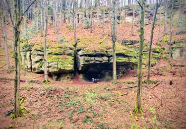
Mooie, eenvoudige wandeling.
Opmerkingen? flip96@home.nl
Plaatsbepaling
Land:
Luxembourg
Regio :
Onbekend
Departement/Provincie :
Canton Echternach
Gemeente :
Bech
Locatie:
Unknown
Vertrek:(Dec)
Vertrek:(UTM)
307547 ; 5514291 (32U) N.
Opmerkingen
Wandeltochten in de omgeving
![Tocht Stappen Consdorf - 2023-06-19_09h33m43_Sentier_local_-_C6 - Photo](https://media.geolcdn.com/t/375/260/1a93b691-9fc1-4ff8-ae1a-57fcf6e1418e.jpg&format=jpg&maxdim=2)
![Stappen Stappen](https://static1.geolcdn.com/sitytour/trail-icons/101.png)
2023-06-19_09h33m43_Sentier_local_-_C6
Stappen
Medium
(1)
Consdorf,
Onbekend,
Canton Echternach,
Luxembourg
![](/images/other/stat-length.png)
5,8 km | 7,3 km-effort
1h 39min
![](https://static1.geolcdn.com/siteimages/upload/files/16400158638029165_repeat_loop_refresh_sync_direction_icon.png)
Ja
![Tocht Stappen Consdorf - 2023-06-13_20h43m48_Sentier_local_-_C2 - Photo](https://media.geolcdn.com/t/375/260/0cc79ac2-8683-4672-970a-cfe76e408507.jpg&format=jpg&maxdim=2)
![Stappen Stappen](https://static1.geolcdn.com/sitytour/trail-icons/101.png)
2023-06-13_20h43m48_Sentier_local_-_C2
Stappen
Gemakkelijk
(1)
Consdorf,
Onbekend,
Canton Echternach,
Luxembourg
![](/images/other/stat-length.png)
4,2 km | 5,5 km-effort
1h 15min
![](https://static1.geolcdn.com/siteimages/upload/files/16400158638029165_repeat_loop_refresh_sync_direction_icon.png)
Ja
![Tocht Stappen Consdorf - 2023-06-13_20h03m09_Circuit_auto-pdestre_Consdorf_-_Mullerthal - Photo](https://media.geolcdn.com/t/375/260/43e83e22-9e28-4a45-bf58-3588aa9e8a2f.jpg&format=jpg&maxdim=2)
![Stappen Stappen](https://static1.geolcdn.com/sitytour/trail-icons/101.png)
2023-06-13_20h03m09_Circuit_auto-pdestre_Consdorf_-_Mullerthal
Stappen
Medium
(2)
Consdorf,
Onbekend,
Canton Echternach,
Luxembourg
![](/images/other/stat-length.png)
9 km | 12,3 km-effort
2h 48min
![](https://static1.geolcdn.com/siteimages/upload/files/16400158638029165_repeat_loop_refresh_sync_direction_icon.png)
Ja
![Tocht Stappen Waldbillig - Mullerthal randonnée magnifique - Photo](https://media.geolcdn.com/t/375/260/3f58fb00-23e0-4e5f-be44-94a05c44c601.jpg&format=jpg&maxdim=2)
![Stappen Stappen](https://static1.geolcdn.com/sitytour/trail-icons/101.png)
Mullerthal randonnée magnifique
Stappen
Moeilijk
(4)
Waldbillig,
Onbekend,
Canton Echternach,
Luxembourg
![](/images/other/stat-length.png)
9,3 km | 12,9 km-effort
4h 21min
![](https://static1.geolcdn.com/siteimages/upload/files/16400158638029165_repeat_loop_refresh_sync_direction_icon.png)
Ja
![Tocht Stappen Consdorf - 2023-06-21_17h04m10_Sentier_local_-_C1 (1) - Photo](https://media.geolcdn.com/t/375/260/67bec963-192a-46c1-a89d-070dac0d9ebc.jpg&format=jpg&maxdim=2)
![Stappen Stappen](https://static1.geolcdn.com/sitytour/trail-icons/101.png)
2023-06-21_17h04m10_Sentier_local_-_C1 (1)
Stappen
Gemakkelijk
(1)
Consdorf,
Onbekend,
Canton Echternach,
Luxembourg
![](/images/other/stat-length.png)
1,9 km | 2,5 km-effort
34min
![](https://static1.geolcdn.com/siteimages/upload/files/16400158638029165_repeat_loop_refresh_sync_direction_icon.png)
Ja
![Tocht Stappen Waldbillig - MÜLLERTHAL (Cascades) - Photo](https://media.geolcdn.com/t/375/260/ext.jpg?maxdim=2&url=https%3A%2F%2Fservices.sitytrail.com%2FGeolivesWS%2FDownloadMedia.ashx%3FTrailID%3D815203%26Media%3Dfix__20170822135510.jpg)
![Stappen Stappen](https://static1.geolcdn.com/sitytour/trail-icons/101.png)
MÜLLERTHAL (Cascades)
Stappen
Medium
(1)
Waldbillig,
Onbekend,
Canton Echternach,
Luxembourg
![](/images/other/stat-length.png)
10,2 km | 13,7 km-effort
3h 1min
![](https://static1.geolcdn.com/siteimages/upload/files/16400158638029165_repeat_loop_refresh_sync_direction_icon.png)
Ja
![Tocht Andere activiteiten Waldbillig - Luxemburg: Mullerthal - Consdorf - Mullerthal - Photo](https://media.geolcdn.com/t/375/260/ext.jpg?maxdim=2&url=https%3A%2F%2Fservices.sitytrail.com%2FGeolivesWS%2FDownloadMedia.ashx%3FTrailID%3D727411%26Media%3D20170405143630.jpg)
![Andere activiteiten Andere activiteiten](https://static1.geolcdn.com/sitytour/trail-icons/900.png)
Luxemburg: Mullerthal - Consdorf - Mullerthal
Andere activiteiten
Zeer moeilijk
(3)
Waldbillig,
Onbekend,
Canton Echternach,
Luxembourg
![](/images/other/stat-length.png)
11,5 km | 15,4 km-effort
4h 10min
![](https://static1.geolcdn.com/siteimages/upload/files/16400158638029165_repeat_loop_refresh_sync_direction_icon.png)
Ja
![Tocht Stappen Waldbillig - Müllerthal W7 par la déviation - Photo](https://media.geolcdn.com/t/375/260/8d10e05b-8c1b-4794-a2ae-2af84a59d337.jpg&format=jpg&maxdim=2)
![Stappen Stappen](https://static1.geolcdn.com/sitytour/trail-icons/101.png)
Müllerthal W7 par la déviation
Stappen
Medium
Waldbillig,
Onbekend,
Canton Echternach,
Luxembourg
![](/images/other/stat-length.png)
11,3 km | 14,8 km-effort
2h 46min
![](https://static1.geolcdn.com/siteimages/upload/files/16400158638029165_repeat_loop_refresh_sync_direction_icon.png)
Ja
![Tocht Stappen Junglinster - Itinérant Luxembourg Jour 3: Graulinster- Echternach - Photo](https://media.geolcdn.com/t/375/260/2c9e1c12-fb8f-4eb6-9b8a-8c6b5d5c7498.jpg&format=jpg&maxdim=2)
![Stappen Stappen](https://static1.geolcdn.com/sitytour/trail-icons/101.png)
Itinérant Luxembourg Jour 3: Graulinster- Echternach
Stappen
Zeer moeilijk
Junglinster,
Onbekend,
Canton Grevenmacher,
Luxembourg
![](/images/other/stat-length.png)
30 km | 37 km-effort
6h 51min
![](https://static1.geolcdn.com/siteimages/upload/files/16400158638029165_repeat_loop_refresh_sync_direction_icon.png)
Neen