![](/images/other/stat-length.png)
![Tocht Stappen Botsorhel - Sentiers buissonniers à Botsorhel - Photo](https://media.geolcdn.com/t/1900/400/ext.pjpeg?maxdim=2&url=https%3A%2F%2Fservices.sitytrail.com%2FGeolivesWS%2FDownloadMedia.ashx%3FTrailID%3D191648%26Media%3D15299_6.jpg)
Sentiers buissonniers à Botsorhel
tracegps
Gebruiker
![Lengte](/images/other/stat-length.png)
Lengte
14,2 km
![Max. hoogte](https://static1.geolcdn.com/siteimages/upload/files/1508320355ic_sort_altitude_max_24dp.png)
Max. hoogte
218 m
![Positief hoogteverschil](https://static1.geolcdn.com/siteimages/upload/files/1508320355ic_sort_den_pos_24dp.png)
Positief hoogteverschil
323 m
![Km-Effort](/images/other/stat-length.png)
Km-Effort
18,5 km
![Min. hoogte](https://static1.geolcdn.com/siteimages/upload/files/1508320355ic_sort_altitude_min_24dp.png)
Min. hoogte
124 m
![Negatief hoogteverschil](https://static1.geolcdn.com/siteimages/upload/files/1508320355ic_sort_den_neg_24dp.png)
Negatief hoogteverschil
323 m
![Boucle](https://static1.geolcdn.com/siteimages/upload/files/16400158638029165_repeat_loop_refresh_sync_direction_icon.png)
Boucle
Ja
Datum van aanmaak :
2014-12-10 00:00:00.0
Laatste wijziging :
2014-12-10 00:00:00.0
![Stappen](https://static1.geolcdn.com/sitytour/trail-icons/101.png)
4h30
Moeilijkheid : Moeilijk
![Scan deze QR-code om de tocht te openen in de SityTrail-applicatie](https://capi.geolives.com/qq0zvz2zws4bq2lad0pu/sitytour/trails/191648/qr.png?size=200)
Gratisgps-wandelapplicatie
Over ons
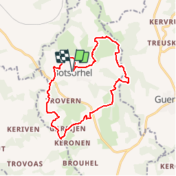
Tocht Stappen van 14,2 km beschikbaar op Bretagne, Finistère, Botsorhel. Deze tocht wordt voorgesteld door tracegps.
Beschrijving
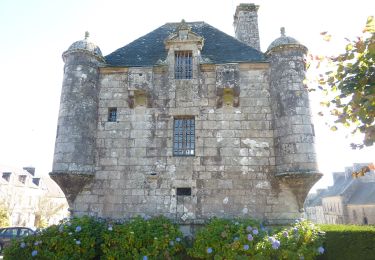
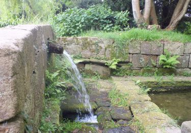
Départ de l'église Saint-Georges de Botsorhel. Le circuit emprunte des sentiers dans un terrain bosselé et verdoyant. Il passe à proximité du château de Keraël et des ruines d'un moulin.
Plaatsbepaling
Land:
France
Regio :
Bretagne
Departement/Provincie :
Finistère
Gemeente :
Botsorhel
Locatie:
Unknown
Vertrek:(Dec)
Vertrek:(UTM)
452621 ; 5375030 (30U) N.
Opmerkingen
Wandeltochten in de omgeving
![Tocht Te voet Guerlesquin - L'Étang du Guic - Photo](https://media.geolcdn.com/t/375/260/ext.jpg?maxdim=2&url=https%3A%2F%2Fmedia.geolcdn.com%2Ff%2Fe37d09e2-5e71-44c7-8599-762e549e8bd0.jpeg)
![Te voet Te voet](https://static1.geolcdn.com/sitytour/trail-icons/100.png)
L'Étang du Guic
Te voet
Medium
Guerlesquin,
Bretagne,
Finistère,
France
![](/images/other/stat-length.png)
15,9 km | 20 km-effort
4h 33min
![](https://static1.geolcdn.com/siteimages/upload/files/16400158638029165_repeat_loop_refresh_sync_direction_icon.png)
Ja
![Tocht Stappen Lannéanou - Tour de Lannéanou - Photo](https://media.geolcdn.com/t/375/260/ext.jpg?maxdim=2&url=https%3A%2F%2Fservices.sitytrail.com%2FGeolivesWS%2FDownloadMedia.ashx%3FTrailID%3D316914%26Media%3D16013_3.jpg)
![Stappen Stappen](https://static1.geolcdn.com/sitytour/trail-icons/101.png)
Tour de Lannéanou
Stappen
Moeilijk
Lannéanou,
Bretagne,
Finistère,
France
![](/images/other/stat-length.png)
14,8 km | 18,8 km-effort
3h 40min
![](https://static1.geolcdn.com/siteimages/upload/files/16400158638029165_repeat_loop_refresh_sync_direction_icon.png)
Ja
![Tocht Stappen Plouégat-Moysan - Ménez Meur - Plouégat - Photo](https://media.geolcdn.com/t/375/260/ext.jpg?maxdim=2&url=https%3A%2F%2Fservices.sitytrail.com%2FGeolivesWS%2FDownloadMedia.ashx%3FTrailID%3D172440%26Media%3D13788_1.jpg)
![Stappen Stappen](https://static1.geolcdn.com/sitytour/trail-icons/101.png)
Ménez Meur - Plouégat
Stappen
Medium
Plouégat-Moysan,
Bretagne,
Finistère,
France
![](/images/other/stat-length.png)
12,2 km | 15,2 km-effort
3h 30min
![](https://static1.geolcdn.com/siteimages/upload/files/16400158638029165_repeat_loop_refresh_sync_direction_icon.png)
Ja
![Tocht Stappen Botsorhel - 29_Botsorhel - Photo](https://media.geolcdn.com/t/375/260/ext.jpg?maxdim=2&url=https%3A%2F%2Fstatic1.geolcdn.com%2Fsiteimages%2Fupload%2Ffiles%2F1553511878bg_sport_marche.png)
![Stappen Stappen](https://static1.geolcdn.com/sitytour/trail-icons/101.png)
29_Botsorhel
Stappen
Medium
Botsorhel,
Bretagne,
Finistère,
France
![](/images/other/stat-length.png)
14,3 km | 18,6 km-effort
3h 22min
![](https://static1.geolcdn.com/siteimages/upload/files/16400158638029165_repeat_loop_refresh_sync_direction_icon.png)
Ja
![Tocht Te voet Botsorhel - Botshorel Morlaix - Photo](https://media.geolcdn.com/t/375/260/ext.jpg?maxdim=2&url=https%3A%2F%2Fstatic1.geolcdn.com%2Fsiteimages%2Fupload%2Ffiles%2F1545311037marcheuse_200dpi.jpg)
![Te voet Te voet](https://static1.geolcdn.com/sitytour/trail-icons/100.png)
Botshorel Morlaix
Te voet
Moeilijk
Botsorhel,
Bretagne,
Finistère,
France
![](/images/other/stat-length.png)
29 km | 35 km-effort
8h 3min
![](https://static1.geolcdn.com/siteimages/upload/files/16400158638029165_repeat_loop_refresh_sync_direction_icon.png)
Neen
![Tocht Te voet Botsorhel - 2022-04-02_21h02m45_SityTrail - 3150665 - et5xbotsorhelxmorlaix - Photo](https://media.geolcdn.com/t/375/260/ext.jpg?maxdim=2&url=https%3A%2F%2Fstatic1.geolcdn.com%2Fsiteimages%2Fupload%2Ffiles%2F1545311037marcheuse_200dpi.jpg)
![Te voet Te voet](https://static1.geolcdn.com/sitytour/trail-icons/100.png)
2022-04-02_21h02m45_SityTrail - 3150665 - et5xbotsorhelxmorlaix
Te voet
Moeilijk
Botsorhel,
Bretagne,
Finistère,
France
![](/images/other/stat-length.png)
30 km | 36 km-effort
8h 10min
![](https://static1.geolcdn.com/siteimages/upload/files/16400158638029165_repeat_loop_refresh_sync_direction_icon.png)
Neen
![Tocht Stappen Plouigneau - le ponthou - Photo](https://media.geolcdn.com/t/375/260/ext.jpg?maxdim=2&url=https%3A%2F%2Fstatic1.geolcdn.com%2Fsiteimages%2Fupload%2Ffiles%2F1553511878bg_sport_marche.png)
![Stappen Stappen](https://static1.geolcdn.com/sitytour/trail-icons/101.png)
le ponthou
Stappen
Heel gemakkelijk
Plouigneau,
Bretagne,
Finistère,
France
![](/images/other/stat-length.png)
7,6 km | 9,3 km-effort
2h 31min
![](https://static1.geolcdn.com/siteimages/upload/files/16400158638029165_repeat_loop_refresh_sync_direction_icon.png)
Neen
![Tocht Stappen Plouigneau - bourouguel broheon la boissiere etc... - Photo](https://media.geolcdn.com/t/375/260/ext.jpg?maxdim=2&url=https%3A%2F%2Fservices.sitytrail.com%2FGeolivesWS%2FDownloadMedia.ashx%3FTrailID%3D222651%26Media%3D20130922153632.jpg)
![Stappen Stappen](https://static1.geolcdn.com/sitytour/trail-icons/101.png)
bourouguel broheon la boissiere etc...
Stappen
Heel gemakkelijk
Plouigneau,
Bretagne,
Finistère,
France
![](/images/other/stat-length.png)
5,7 km | 6,8 km-effort
1h 51min
![](https://static1.geolcdn.com/siteimages/upload/files/16400158638029165_repeat_loop_refresh_sync_direction_icon.png)
Ja
![Tocht Fiets Plouigneau - velo bourouguel kermadeen++ - Photo](https://media.geolcdn.com/t/375/260/ext.jpg?maxdim=2&url=https%3A%2F%2Fstatic1.geolcdn.com%2Fsiteimages%2Fupload%2Ffiles%2F1524743154velo.jpg)
![Fiets Fiets](https://static1.geolcdn.com/sitytour/trail-icons/200.png)
velo bourouguel kermadeen++
Fiets
Heel gemakkelijk
Plouigneau,
Bretagne,
Finistère,
France
![](/images/other/stat-length.png)
5 km | 5,8 km-effort
38min
![](https://static1.geolcdn.com/siteimages/upload/files/16400158638029165_repeat_loop_refresh_sync_direction_icon.png)
Ja
tour de botsorhel