![](/images/other/stat-length.png)
![Tocht Mountainbike Baignes-Sainte-Radegonde - Les Cagouilles - Baignes Sainte Radegonde - Photo](https://media.geolcdn.com/t/1900/400/ext.pjpeg?maxdim=2&url=https%3A%2F%2Fservices.sitytrail.com%2FGeolivesWS%2FDownloadMedia.ashx%3FTrailID%3D191565%26Media%3D15184_1.jpg)
Les Cagouilles - Baignes Sainte Radegonde
tracegps
Gebruiker
![Lengte](/images/other/stat-length.png)
Lengte
35 km
![Max. hoogte](https://static1.geolcdn.com/siteimages/upload/files/1508320355ic_sort_altitude_max_24dp.png)
Max. hoogte
149 m
![Positief hoogteverschil](https://static1.geolcdn.com/siteimages/upload/files/1508320355ic_sort_den_pos_24dp.png)
Positief hoogteverschil
385 m
![Km-Effort](/images/other/stat-length.png)
Km-Effort
40 km
![Min. hoogte](https://static1.geolcdn.com/siteimages/upload/files/1508320355ic_sort_altitude_min_24dp.png)
Min. hoogte
64 m
![Negatief hoogteverschil](https://static1.geolcdn.com/siteimages/upload/files/1508320355ic_sort_den_neg_24dp.png)
Negatief hoogteverschil
383 m
![Boucle](https://static1.geolcdn.com/siteimages/upload/files/16400158638029165_repeat_loop_refresh_sync_direction_icon.png)
Boucle
Ja
Datum van aanmaak :
2014-12-10 00:00:00.0
Laatste wijziging :
2014-12-10 00:00:00.0
![Mountainbike](https://static1.geolcdn.com/sitytour/trail-icons/202.png)
3h00
Moeilijkheid : Medium
![Scan deze QR-code om de tocht te openen in de SityTrail-applicatie](https://capi.geolives.com/qq0zvz2zws4bq2lad0pu/sitytour/trails/191565/qr.png?size=200)
Gratisgps-wandelapplicatie
Over ons
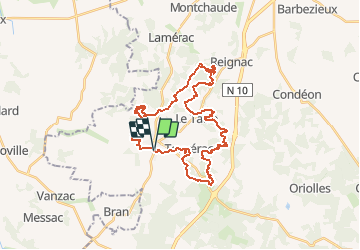
Tocht Mountainbike van 35 km beschikbaar op Nieuw-Aquitanië, Charente, Baignes-Sainte-Radegonde. Deze tocht wordt voorgesteld door tracegps.
Beschrijving
Circuit principalement en sous bois dont le profil est très varié et comporte des passages techniques. Départ au champs de l'abbaye tout prés de l'église de Baignes.
Plaatsbepaling
Land:
France
Regio :
Nieuw-Aquitanië
Departement/Provincie :
Charente
Gemeente :
Baignes-Sainte-Radegonde
Locatie:
Unknown
Vertrek:(Dec)
Vertrek:(UTM)
716448 ; 5028809 (30T) N.
Opmerkingen
Wandeltochten in de omgeving
![Tocht Stappen Touvérac - Touverac 16. 15 mai 2018 - Photo](https://media.geolcdn.com/t/375/260/ext.jpg?maxdim=2&url=https%3A%2F%2Fservices.sitytrail.com%2FGeolivesWS%2FDownloadMedia.ashx%3FTrailID%3D966721%26Media%3Dfix__20180515112606.jpg)
![Stappen Stappen](https://static1.geolcdn.com/sitytour/trail-icons/101.png)
Touverac 16. 15 mai 2018
Stappen
Heel gemakkelijk
Touvérac,
Nieuw-Aquitanië,
Charente,
France
![](/images/other/stat-length.png)
3,9 km | 4,8 km-effort
1h 2min
![](https://static1.geolcdn.com/siteimages/upload/files/16400158638029165_repeat_loop_refresh_sync_direction_icon.png)
Ja
![Tocht Mountainbike Baignes-Sainte-Radegonde - Les Cagouilles 50 km - Baignes Sainte Radegonde - Photo](https://media.geolcdn.com/t/375/260/ext.jpg?maxdim=2&url=https%3A%2F%2Fservices.sitytrail.com%2FGeolivesWS%2FDownloadMedia.ashx%3FTrailID%3D215113%26Media%3D15699_6.jpg)
![Mountainbike Mountainbike](https://static1.geolcdn.com/sitytour/trail-icons/202.png)
Les Cagouilles 50 km - Baignes Sainte Radegonde
Mountainbike
Medium
Baignes-Sainte-Radegonde,
Nieuw-Aquitanië,
Charente,
France
![](/images/other/stat-length.png)
48 km | 55 km-effort
4h 0min
![](https://static1.geolcdn.com/siteimages/upload/files/16400158638029165_repeat_loop_refresh_sync_direction_icon.png)
Ja
![Tocht Stappen Bran - Bran 13 - Photo](https://media.geolcdn.com/t/375/260/ext.jpg?maxdim=2&url=https%3A%2F%2Fstatic1.geolcdn.com%2Fsiteimages%2Fupload%2Ffiles%2F1553511878bg_sport_marche.png)
![Stappen Stappen](https://static1.geolcdn.com/sitytour/trail-icons/101.png)
Bran 13
Stappen
Medium
Bran,
Nieuw-Aquitanië,
Charente-Maritime,
France
![](/images/other/stat-length.png)
12,3 km | 14,5 km-effort
2h 52min
![](https://static1.geolcdn.com/siteimages/upload/files/16400158638029165_repeat_loop_refresh_sync_direction_icon.png)
Ja
![Tocht Stappen Bran - Bran 15km - Photo](https://media.geolcdn.com/t/375/260/ext.jpg?maxdim=2&url=https%3A%2F%2Fstatic1.geolcdn.com%2Fsiteimages%2Fupload%2Ffiles%2F1553511878bg_sport_marche.png)
![Stappen Stappen](https://static1.geolcdn.com/sitytour/trail-icons/101.png)
Bran 15km
Stappen
Medium
Bran,
Nieuw-Aquitanië,
Charente-Maritime,
France
![](/images/other/stat-length.png)
15,2 km | 17,6 km-effort
3h 20min
![](https://static1.geolcdn.com/siteimages/upload/files/16400158638029165_repeat_loop_refresh_sync_direction_icon.png)
Ja
![Tocht Stappen Baignes-Sainte-Radegonde - Baignes st Radegonde 13,8km - Photo](https://media.geolcdn.com/t/375/260/ext.jpg?maxdim=2&url=https%3A%2F%2Fstatic1.geolcdn.com%2Fsiteimages%2Fupload%2Ffiles%2F1553511878bg_sport_marche.png)
![Stappen Stappen](https://static1.geolcdn.com/sitytour/trail-icons/101.png)
Baignes st Radegonde 13,8km
Stappen
Gemakkelijk
Baignes-Sainte-Radegonde,
Nieuw-Aquitanië,
Charente,
France
![](/images/other/stat-length.png)
13,8 km | 15,6 km-effort
2h 58min
![](https://static1.geolcdn.com/siteimages/upload/files/16400158638029165_repeat_loop_refresh_sync_direction_icon.png)
Ja
![Tocht Stappen Bran - Bran 11km - Photo](https://media.geolcdn.com/t/375/260/ext.jpg?maxdim=2&url=https%3A%2F%2Fstatic1.geolcdn.com%2Fsiteimages%2Fupload%2Ffiles%2F1553511878bg_sport_marche.png)
![Stappen Stappen](https://static1.geolcdn.com/sitytour/trail-icons/101.png)
Bran 11km
Stappen
Heel gemakkelijk
Bran,
Nieuw-Aquitanië,
Charente-Maritime,
France
![](/images/other/stat-length.png)
10,8 km | 12,5 km-effort
2h 26min
![](https://static1.geolcdn.com/siteimages/upload/files/16400158638029165_repeat_loop_refresh_sync_direction_icon.png)
Ja
![Tocht Stappen Bran - Bran 14,6 km - Photo](https://media.geolcdn.com/t/375/260/ext.jpg?maxdim=2&url=https%3A%2F%2Fstatic1.geolcdn.com%2Fsiteimages%2Fupload%2Ffiles%2F1553511878bg_sport_marche.png)
![Stappen Stappen](https://static1.geolcdn.com/sitytour/trail-icons/101.png)
Bran 14,6 km
Stappen
Gemakkelijk
Bran,
Nieuw-Aquitanië,
Charente-Maritime,
France
![](/images/other/stat-length.png)
14,6 km | 16,6 km-effort
3h 11min
![](https://static1.geolcdn.com/siteimages/upload/files/16400158638029165_repeat_loop_refresh_sync_direction_icon.png)
Ja
![Tocht Noords wandelen Reignac - Reignac - Photo](https://media.geolcdn.com/t/375/260/ext.jpg?maxdim=2&url=https%3A%2F%2Fstatic1.geolcdn.com%2Fsiteimages%2Fupload%2Ffiles%2F1545311037marcheuse_200dpi.jpg)
![Noords wandelen Noords wandelen](https://static1.geolcdn.com/sitytour/trail-icons/102.png)
Reignac
Noords wandelen
Heel gemakkelijk
Reignac,
Nieuw-Aquitanië,
Charente,
France
![](/images/other/stat-length.png)
15,5 km | 17,9 km-effort
4h 23min
![](https://static1.geolcdn.com/siteimages/upload/files/16400158638029165_repeat_loop_refresh_sync_direction_icon.png)
Ja
![Tocht Stappen Touvérac - Touverac 11 km - Photo](https://media.geolcdn.com/t/375/260/ext.jpg?maxdim=2&url=https%3A%2F%2Fstatic1.geolcdn.com%2Fsiteimages%2Fupload%2Ffiles%2F1553511878bg_sport_marche.png)
![Stappen Stappen](https://static1.geolcdn.com/sitytour/trail-icons/101.png)
Touverac 11 km
Stappen
Gemakkelijk
Touvérac,
Nieuw-Aquitanië,
Charente,
France
![](/images/other/stat-length.png)
11 km | 12,6 km-effort
2h 54min
![](https://static1.geolcdn.com/siteimages/upload/files/16400158638029165_repeat_loop_refresh_sync_direction_icon.png)
Ja