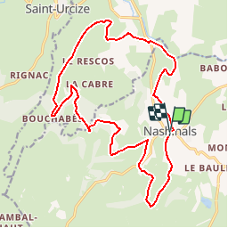
![](/images/other/stat-length.png)
![Tocht Mountainbike Nasbinals - Grande Traversée de l'Aubrac VTT 2013 - circuit 2 - Nasbinals - Photo](https://media.geolcdn.com/t/1900/400/ext.pjpeg?maxdim=2&url=https%3A%2F%2Fservices.sitytrail.com%2FGeolivesWS%2FDownloadMedia.ashx%3FTrailID%3D191560%26Media%3D15178_2.jpg)
Grande Traversée de l'Aubrac VTT 2013 - circuit 2 - Nasbinals
tracegps
Gebruiker
![Lengte](/images/other/stat-length.png)
![Max. hoogte](https://static1.geolcdn.com/siteimages/upload/files/1508320355ic_sort_altitude_max_24dp.png)
![Positief hoogteverschil](https://static1.geolcdn.com/siteimages/upload/files/1508320355ic_sort_den_pos_24dp.png)
![Km-Effort](/images/other/stat-length.png)
![Min. hoogte](https://static1.geolcdn.com/siteimages/upload/files/1508320355ic_sort_altitude_min_24dp.png)
![Negatief hoogteverschil](https://static1.geolcdn.com/siteimages/upload/files/1508320355ic_sort_den_neg_24dp.png)
![Boucle](https://static1.geolcdn.com/siteimages/upload/files/16400158638029165_repeat_loop_refresh_sync_direction_icon.png)
![Mountainbike](https://static1.geolcdn.com/sitytour/trail-icons/202.png)
2h00
Moeilijkheid : Medium
![Scan deze QR-code om de tocht te openen in de SityTrail-applicatie](https://capi.geolives.com/qq0zvz2zws4bq2lad0pu/sitytour/trails/191560/qr.png?size=200)
Gratisgps-wandelapplicatie
Over ons
Tocht Mountainbike van 21 km beschikbaar op Occitanië, Lozère, Nasbinals. Deze tocht wordt voorgesteld door tracegps.
Beschrijving
Le VTT est pratiqué depuis plus de 20 ans et il est temps d’organiser sur l’Aubrac une manifestation à ce sujet. Enfin ! Le Samedi 01 JUIN 2013 est la date choisie pour cette grande manifestation. Les organisateurs sont heureux de vous inviter à cette randonnée nommée G.T.A VTT (Grande traversée de l’AUBRAC en Vélo Tout Terrain) qui est prévue autant pour les familles que pour les vététistes aguerris. Il y a deux parcours d’environ 20 km et 40km avec un petit plus, une randonnée pédestre pour les accompagnants.( familles et enfants). L’avantage est que l’épreuve empreinte très peu de route et uniquement des chemins communaux et sentiers monotraces techniques. Nous pouvons d’ores et déjà confirmer qu’un Lot spécial sera offert au Club ou Association sportive qui sera le mieux représenté. Les commerçants et entreprises locales vont participer très largement à faire aboutir la GTA. Inscription à partir de 7h30 le jour de l’épreuve, départ libre sur parcours balisés, pour 2 boucles avec ravitaillement à mi-parcours, au cœur du village pour le 40km et en fin de parcours pour la boucle de 20km. Dénivelé de 350m positif pour le 20km et ± 1000mètres pour le 40km. Un lot souvenir offert à tous les participants. Possibilité de nettoyage des vélos à l’arrivée, restauration dans le village. Départ place du foirail avec parking conséquent. (Ce n’est pas une épreuve chronométrée cette année, nous demanderons aux participants de respecter le code de la route). Nous acceptons toutes vos critiques afin de faire évoluer cette manifestation et nous nous tenons prêt à répondre à vos interrogations. Sportivement à tous, rendez-le 01 juin ! Pour nous contacter vamm12 (at) orange.fr
Plaatsbepaling
Opmerkingen
Wandeltochten in de omgeving
![Tocht Stappen Marchastel - Rieutort lac san andeol cascade deroc - Photo](https://media.geolcdn.com/t/375/260/33c320b5-cb8a-49f6-87c9-e02583e6c71a.jpg&format=jpg&maxdim=2)
![Stappen Stappen](https://static1.geolcdn.com/sitytour/trail-icons/101.png)
Stappen
![](/images/other/stat-length.png)
![](https://static1.geolcdn.com/siteimages/upload/files/16400158638029165_repeat_loop_refresh_sync_direction_icon.png)
![Tocht Stappen Saint-Chély-d'Aubrac - Aubrac - St Côme d'Olt - Chemin de St-Jacques de Compostelle - Photo](https://media.geolcdn.com/t/375/260/ext.jpg?maxdim=2&url=https%3A%2F%2Fservices.sitytrail.com%2FGeolivesWS%2FDownloadMedia.ashx%3FTrailID%3D108743%26Media%3D1838_2.jpg)
![Stappen Stappen](https://static1.geolcdn.com/sitytour/trail-icons/101.png)
Stappen
![](/images/other/stat-length.png)
![](https://static1.geolcdn.com/siteimages/upload/files/16400158638029165_repeat_loop_refresh_sync_direction_icon.png)
![Tocht Stappen Nasbinals - Nasbinals Montorzier Aubrac GR65 - Photo](https://media.geolcdn.com/t/375/260/1ac3a438-86b6-472c-99e2-7da904ac9db5.jpg&format=jpg&maxdim=2)
![Stappen Stappen](https://static1.geolcdn.com/sitytour/trail-icons/101.png)
Stappen
![](/images/other/stat-length.png)
![](https://static1.geolcdn.com/siteimages/upload/files/16400158638029165_repeat_loop_refresh_sync_direction_icon.png)
![Tocht Stappen Saint-Chély-d'Aubrac - Mon chemin de St Guilhem étape 3 - Photo](https://media.geolcdn.com/t/375/260/decc6e0e-cc63-493a-98a1-a20926931e85.jpg&format=jpg&maxdim=2)
![Stappen Stappen](https://static1.geolcdn.com/sitytour/trail-icons/101.png)
Stappen
![](/images/other/stat-length.png)
![](https://static1.geolcdn.com/siteimages/upload/files/16400158638029165_repeat_loop_refresh_sync_direction_icon.png)
![Tocht Te voet Nasbinals - chemin de Saint-Jacques-de-Compostelle pour randonneurs avec animaux (chien, ane, cheval) ou VTT - Photo](https://media.geolcdn.com/t/375/260/ce1c8375-c87d-45df-90e9-7235318ed55e.jpeg&format=jpg&maxdim=2)
![Te voet Te voet](https://static1.geolcdn.com/sitytour/trail-icons/100.png)
Te voet
![](/images/other/stat-length.png)
![](https://static1.geolcdn.com/siteimages/upload/files/16400158638029165_repeat_loop_refresh_sync_direction_icon.png)
![Tocht Stappen Saint-Urcize - St Urcize Carbonade Goutal Recoules - Photo](https://media.geolcdn.com/t/375/260/d5696f6e-bd72-472a-8c47-6bfe1d54378a.jpg&format=jpg&maxdim=2)
![Stappen Stappen](https://static1.geolcdn.com/sitytour/trail-icons/101.png)
Stappen
![](/images/other/stat-length.png)
![](https://static1.geolcdn.com/siteimages/upload/files/16400158638029165_repeat_loop_refresh_sync_direction_icon.png)
![Tocht Stappen Recoules-d'Aubrac - Pont de Gourmier Grandval - Photo](https://media.geolcdn.com/t/375/260/ffa21da4-3882-4a5f-ba26-03b7d7246554.jpg&format=jpg&maxdim=2)
![Stappen Stappen](https://static1.geolcdn.com/sitytour/trail-icons/101.png)
Stappen
![](/images/other/stat-length.png)
![](https://static1.geolcdn.com/siteimages/upload/files/16400158638029165_repeat_loop_refresh_sync_direction_icon.png)
![Tocht Stappen Saint-Urcize - St urcize - Photo](https://media.geolcdn.com/t/375/260/84e5b137-319d-4d6f-808d-85721d4634b7.jpg&format=jpg&maxdim=2)
![Stappen Stappen](https://static1.geolcdn.com/sitytour/trail-icons/101.png)
Stappen
![](/images/other/stat-length.png)
![](https://static1.geolcdn.com/siteimages/upload/files/16400158638029165_repeat_loop_refresh_sync_direction_icon.png)
![Tocht Stappen Recoules-d'Aubrac - Au temps des fleurs et des genêts - Photo](https://media.geolcdn.com/t/375/260/5a185ad9-06d4-44d6-9906-03e9d4e1b2f0.jpg&format=jpg&maxdim=2)
![Stappen Stappen](https://static1.geolcdn.com/sitytour/trail-icons/101.png)
Stappen
![](/images/other/stat-length.png)
![](https://static1.geolcdn.com/siteimages/upload/files/16400158638029165_repeat_loop_refresh_sync_direction_icon.png)