![](/images/other/stat-length.png)
![Tocht Stappen Botmeur - Roc'h Bichourel - Botmeur - Photo](https://media.geolcdn.com/t/1900/400/ext.pjpeg?maxdim=2&url=https%3A%2F%2Fservices.sitytrail.com%2FGeolivesWS%2FDownloadMedia.ashx%3FTrailID%3D191436%26Media%3D15024_3.jpg)
Roc'h Bichourel - Botmeur
tracegps
Gebruiker
![Lengte](/images/other/stat-length.png)
Lengte
8,3 km
![Max. hoogte](https://static1.geolcdn.com/siteimages/upload/files/1508320355ic_sort_altitude_max_24dp.png)
Max. hoogte
358 m
![Positief hoogteverschil](https://static1.geolcdn.com/siteimages/upload/files/1508320355ic_sort_den_pos_24dp.png)
Positief hoogteverschil
146 m
![Km-Effort](/images/other/stat-length.png)
Km-Effort
10,2 km
![Min. hoogte](https://static1.geolcdn.com/siteimages/upload/files/1508320355ic_sort_altitude_min_24dp.png)
Min. hoogte
249 m
![Negatief hoogteverschil](https://static1.geolcdn.com/siteimages/upload/files/1508320355ic_sort_den_neg_24dp.png)
Negatief hoogteverschil
143 m
![Boucle](https://static1.geolcdn.com/siteimages/upload/files/16400158638029165_repeat_loop_refresh_sync_direction_icon.png)
Boucle
Ja
Datum van aanmaak :
2014-12-10 00:00:00.0
Laatste wijziging :
2014-12-10 00:00:00.0
![Stappen](https://static1.geolcdn.com/sitytour/trail-icons/101.png)
2h30
Moeilijkheid : Medium
![Scan deze QR-code om de tocht te openen in de SityTrail-applicatie](https://capi.geolives.com/qq0zvz2zws4bq2lad0pu/sitytour/trails/191436/qr.png?size=200)
Gratisgps-wandelapplicatie
Over ons
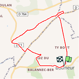
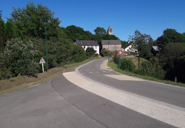
Tocht Stappen van 8,3 km beschikbaar op Bretagne, Finistère, Botmeur. Deze tocht wordt voorgesteld door tracegps.
Beschrijving
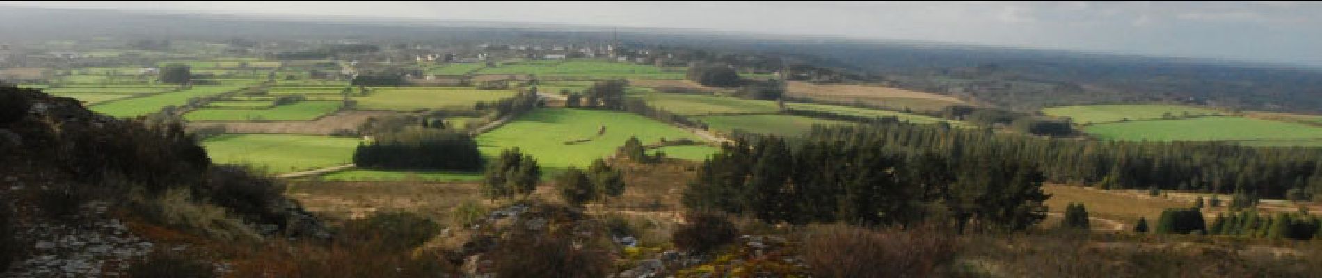
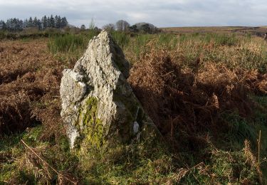
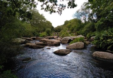
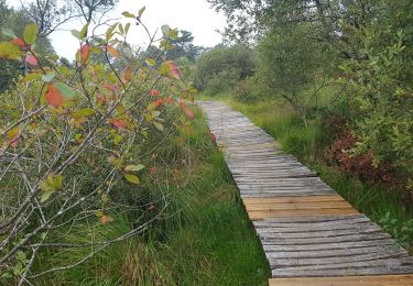
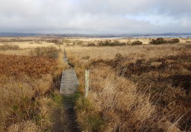
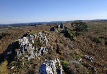
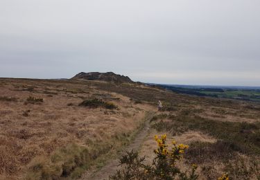
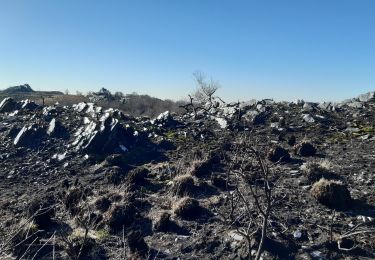
Un circuit au cœur des Monts d'Arrée. Au programme, les landes, les bruyères, les points de vues, les rochers de schiste...... pour cette rando.
Plaatsbepaling
Land:
France
Regio :
Bretagne
Departement/Provincie :
Finistère
Gemeente :
Botmeur
Locatie:
Unknown
Vertrek:(Dec)
Vertrek:(UTM)
432190 ; 5359324 (30U) N.
Opmerkingen
Wandeltochten in de omgeving
![Tocht Te voet Saint-Rivoal - Landes et Tourbières - Photo](https://media.geolcdn.com/t/375/260/c5b98d78-e599-4d6a-ae17-467d21882015.jpeg&format=jpg&maxdim=2)
![Te voet Te voet](https://static1.geolcdn.com/sitytour/trail-icons/100.png)
Landes et Tourbières
Te voet
Gemakkelijk
Saint-Rivoal,
Bretagne,
Finistère,
France
![](/images/other/stat-length.png)
11,8 km | 14,1 km-effort
3h 12min
![](https://static1.geolcdn.com/siteimages/upload/files/16400158638029165_repeat_loop_refresh_sync_direction_icon.png)
Neen
![Tocht Te voet Botmeur - Brasparts Circuit des landes et tourbières - Photo](https://media.geolcdn.com/t/375/260/98159458-f3c1-4612-bed6-39d858fe0671.jpeg&format=jpg&maxdim=2)
![Te voet Te voet](https://static1.geolcdn.com/sitytour/trail-icons/100.png)
Brasparts Circuit des landes et tourbières
Te voet
Gemakkelijk
Botmeur,
Bretagne,
Finistère,
France
![](/images/other/stat-length.png)
3,7 km | 4,2 km-effort
57min
![](https://static1.geolcdn.com/siteimages/upload/files/16400158638029165_repeat_loop_refresh_sync_direction_icon.png)
Neen
![Tocht Stappen Brennilis - BRENNILIS - Photo](https://media.geolcdn.com/t/375/260/6e50cc19-3f4b-431a-97d4-ac04ab141fcb.jpg&format=jpg&maxdim=2)
![Stappen Stappen](https://static1.geolcdn.com/sitytour/trail-icons/101.png)
![Tocht Stappen Brennilis - GR_37_EE_11_Brennilis_St-Rivoal_20200810 - Photo](https://media.geolcdn.com/t/375/260/0b8f7b53-5fb7-445b-b4ed-cfdc9fc70396.jpg&format=jpg&maxdim=2)
![Stappen Stappen](https://static1.geolcdn.com/sitytour/trail-icons/101.png)
GR_37_EE_11_Brennilis_St-Rivoal_20200810
Stappen
Gemakkelijk
Brennilis,
Bretagne,
Finistère,
France
![](/images/other/stat-length.png)
21 km | 25 km-effort
5h 49min
![](https://static1.geolcdn.com/siteimages/upload/files/16400158638029165_repeat_loop_refresh_sync_direction_icon.png)
Neen
![Tocht Stappen La Feuillée - La Feuillée - Huelgoat - Lac St Michel - Photo](https://media.geolcdn.com/t/375/260/ext.jpg?maxdim=2&url=https%3A%2F%2Fservices.sitytrail.com%2FGeolivesWS%2FDownloadMedia.ashx%3FTrailID%3D864600%26Media%3Dfix__20171119120434.jpg)
![Stappen Stappen](https://static1.geolcdn.com/sitytour/trail-icons/101.png)
La Feuillée - Huelgoat - Lac St Michel
Stappen
Medium
La Feuillée,
Bretagne,
Finistère,
France
![](/images/other/stat-length.png)
47 km | 56 km-effort
11h 3min
![](https://static1.geolcdn.com/siteimages/upload/files/16400158638029165_repeat_loop_refresh_sync_direction_icon.png)
Ja
![Tocht Stappen Commana - Circuit de la pierre bleue - Commana - Photo](https://media.geolcdn.com/t/375/260/ext.jpg?maxdim=2&url=https%3A%2F%2Fservices.sitytrail.com%2FGeolivesWS%2FDownloadMedia.ashx%3FTrailID%3D191397%26Media%3D14972_2.jpg)
![Stappen Stappen](https://static1.geolcdn.com/sitytour/trail-icons/101.png)
Circuit de la pierre bleue - Commana
Stappen
Medium
Commana,
Bretagne,
Finistère,
France
![](/images/other/stat-length.png)
15,7 km | 19,7 km-effort
4h 30min
![](https://static1.geolcdn.com/siteimages/upload/files/16400158638029165_repeat_loop_refresh_sync_direction_icon.png)
Ja
![Tocht Stappen La Feuillée - 2023-10-08 Roc'h trévezel - Roc'h ruz - Photo](https://media.geolcdn.com/t/375/260/d8895edc-d4c1-401b-9e6a-1edf2c8902a5.jpg&format=jpg&maxdim=2)
![Stappen Stappen](https://static1.geolcdn.com/sitytour/trail-icons/101.png)
2023-10-08 Roc'h trévezel - Roc'h ruz
Stappen
Heel gemakkelijk
La Feuillée,
Bretagne,
Finistère,
France
![](/images/other/stat-length.png)
6,3 km | 7,4 km-effort
1h 33min
![](https://static1.geolcdn.com/siteimages/upload/files/16400158638029165_repeat_loop_refresh_sync_direction_icon.png)
Ja
![Tocht Stappen La Feuillée - Roc'h 'n Roc'h - Photo](https://media.geolcdn.com/t/375/260/47c13971-e504-451a-b0a8-d2e15e402a97.jpg&format=jpg&maxdim=2)
![Stappen Stappen](https://static1.geolcdn.com/sitytour/trail-icons/101.png)
Roc'h 'n Roc'h
Stappen
Moeilijk
La Feuillée,
Bretagne,
Finistère,
France
![](/images/other/stat-length.png)
12,9 km | 15,5 km-effort
3h 14min
![](https://static1.geolcdn.com/siteimages/upload/files/16400158638029165_repeat_loop_refresh_sync_direction_icon.png)
Ja
![Tocht Stappen Commana - Maugau Bihan - Photo](https://media.geolcdn.com/t/375/260/0a2488ec-2659-438a-9aad-c108d3c772f9.jpg&format=jpg&maxdim=2)
![Stappen Stappen](https://static1.geolcdn.com/sitytour/trail-icons/101.png)
Maugau Bihan
Stappen
Medium
(1)
Commana,
Bretagne,
Finistère,
France
![](/images/other/stat-length.png)
8,9 km | 11,4 km-effort
2h 35min
![](https://static1.geolcdn.com/siteimages/upload/files/16400158638029165_repeat_loop_refresh_sync_direction_icon.png)
Ja