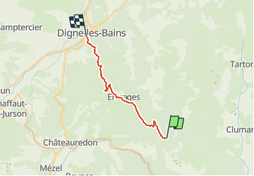
![](/images/other/stat-length.png)
![Tocht Paard Chaudon-Norante - La Voie Impériale (Etape 3 : Chaudon-Norante (La Clappe) - Digne-les-Bains) - Photo](https://media.geolcdn.com/t/1900/400/ext.pjpeg?maxdim=2&url=https%3A%2F%2Fservices.sitytrail.com%2FGeolivesWS%2FDownloadMedia.ashx%3FTrailID%3D191401%26Media%3D14974_6.jpg)
La Voie Impériale (Etape 3 : Chaudon-Norante (La Clappe) - Digne-les-Bains)
tracegps
Gebruiker
![Lengte](/images/other/stat-length.png)
![Max. hoogte](https://static1.geolcdn.com/siteimages/upload/files/1508320355ic_sort_altitude_max_24dp.png)
![Positief hoogteverschil](https://static1.geolcdn.com/siteimages/upload/files/1508320355ic_sort_den_pos_24dp.png)
![Km-Effort](/images/other/stat-length.png)
![Min. hoogte](https://static1.geolcdn.com/siteimages/upload/files/1508320355ic_sort_altitude_min_24dp.png)
![Negatief hoogteverschil](https://static1.geolcdn.com/siteimages/upload/files/1508320355ic_sort_den_neg_24dp.png)
![Boucle](https://static1.geolcdn.com/siteimages/upload/files/16400158638029165_repeat_loop_refresh_sync_direction_icon.png)
![Paard](https://static1.geolcdn.com/sitytour/trail-icons/300.png)
3h45
Moeilijkheid : Moeilijk
![Scan deze QR-code om de tocht te openen in de SityTrail-applicatie](https://capi.geolives.com/qq0zvz2zws4bq2lad0pu/sitytour/trails/191401/qr.png?size=200)
Gratisgps-wandelapplicatie
Over ons
Tocht Paard van 14 km beschikbaar op Provence-Alpes-Côte d'Azur, Alpes-de-Haute-Provence, Chaudon-Norante. Deze tocht wordt voorgesteld door tracegps.
Beschrijving
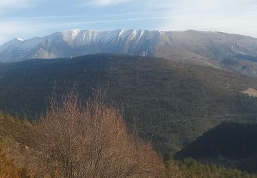
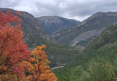
Le 26 février 1815, Napoléon quitte l’île d’Elbe, débarque à Golfe Juan le 1er mars et gagne Paris, avec ses hommes, le 20 mars 1815. Il traverse Castellane et Digne-les-Bains les 3 et 4 mars 1815. Ce cheminement historique a donné lieu à la création d'un itinéraire de randonnée thématique unique en France : la Voie Impériale, reliant Castellane et Digne-les-Bains sur une distance de 52 km. La randonnée qui peut s’effectuer à pied ou à cheval (cavalier confirmé), permet de traverser des paysages encore vierges et authentiques de la Haute Provence et de découvrir un patrimoine remarquable au fil des étapes. Retrouvez la voie Impériale sur le site de la Communauté de Communes du Moyen Verdon.
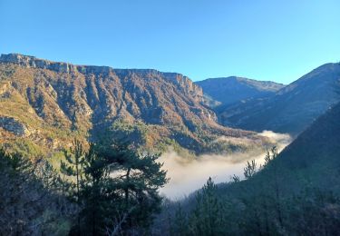
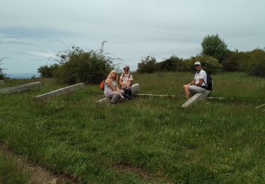
Plaatsbepaling
Opmerkingen
Wandeltochten in de omgeving
![Tocht Stappen Chaudon-Norante - BEYNES . chapelle S Étienne, Creisset o l - Photo](https://media.geolcdn.com/t/375/260/6778bf81-36d6-484d-aa67-aec9eedbcfb4.jpg&format=jpg&maxdim=2)
![Stappen Stappen](https://static1.geolcdn.com/sitytour/trail-icons/101.png)
Stappen
![](/images/other/stat-length.png)
![](https://static1.geolcdn.com/siteimages/upload/files/16400158638029165_repeat_loop_refresh_sync_direction_icon.png)
![Tocht Stappen Entrages - CHABRIERES Pas de l Ane Entrages Pas des Portes clubs navette - Photo](https://media.geolcdn.com/t/375/260/ext.jpg?maxdim=2&url=https%3A%2F%2Fstatic1.geolcdn.com%2Fsiteimages%2Fupload%2Ffiles%2F1553511878bg_sport_marche.png)
![Stappen Stappen](https://static1.geolcdn.com/sitytour/trail-icons/101.png)
Stappen
![](/images/other/stat-length.png)
![](https://static1.geolcdn.com/siteimages/upload/files/16400158638029165_repeat_loop_refresh_sync_direction_icon.png)
![Tocht Stappen Chaudon-Norante - ENTRAGES la Clappe départ ancienne carrière Gozzi - Photo](https://media.geolcdn.com/t/375/260/ext.jpg?maxdim=2&url=https%3A%2F%2Fstatic1.geolcdn.com%2Fsiteimages%2Fupload%2Ffiles%2F1553511878bg_sport_marche.png)
![Stappen Stappen](https://static1.geolcdn.com/sitytour/trail-icons/101.png)
Stappen
![](/images/other/stat-length.png)
![](https://static1.geolcdn.com/siteimages/upload/files/16400158638029165_repeat_loop_refresh_sync_direction_icon.png)
![Tocht Stappen Chaudon-Norante - 2024-12-06 Col des Chandres - Photo](https://media.geolcdn.com/t/375/260/18a1b1b7-1b8d-4060-baf7-b51223b32ca1.jpg&format=jpg&maxdim=2)
![Stappen Stappen](https://static1.geolcdn.com/sitytour/trail-icons/101.png)
Stappen
![](/images/other/stat-length.png)
![](https://static1.geolcdn.com/siteimages/upload/files/16400158638029165_repeat_loop_refresh_sync_direction_icon.png)
![Tocht Stappen Digne-les-Bains - ENTRAGES Tour et crête du Feston o s l - Photo](https://media.geolcdn.com/t/375/260/446f1e20-ab99-4ceb-a654-6accbeab3d1a.jpg&format=jpg&maxdim=2)
![Stappen Stappen](https://static1.geolcdn.com/sitytour/trail-icons/101.png)
Stappen
![](/images/other/stat-length.png)
![](https://static1.geolcdn.com/siteimages/upload/files/16400158638029165_repeat_loop_refresh_sync_direction_icon.png)
![Tocht Stappen Entrages - Tour du Cousson - Photo](https://media.geolcdn.com/t/375/260/bf25b231-7a44-4d48-84ac-a26de00331a4.jpg&format=jpg&maxdim=2)
![Stappen Stappen](https://static1.geolcdn.com/sitytour/trail-icons/101.png)
Stappen
![](/images/other/stat-length.png)
![](https://static1.geolcdn.com/siteimages/upload/files/16400158638029165_repeat_loop_refresh_sync_direction_icon.png)
![Tocht Stappen Clumanc - Clumanc les sauseries 18km 1000m - Photo](https://media.geolcdn.com/t/375/260/ab9a201d-663c-4764-ab07-78458febe485.jpg&format=jpg&maxdim=2)
![Stappen Stappen](https://static1.geolcdn.com/sitytour/trail-icons/101.png)
Stappen
![](/images/other/stat-length.png)
![](https://static1.geolcdn.com/siteimages/upload/files/16400158638029165_repeat_loop_refresh_sync_direction_icon.png)
![Tocht Stappen Entrages - Le Cousson 19.11.23 - Photo](https://media.geolcdn.com/t/375/260/e1d8c8d2-78a9-4959-b3ed-62d29b068506.jpg&format=jpg&maxdim=2)
![Stappen Stappen](https://static1.geolcdn.com/sitytour/trail-icons/101.png)
Stappen
![](/images/other/stat-length.png)
![](https://static1.geolcdn.com/siteimages/upload/files/16400158638029165_repeat_loop_refresh_sync_direction_icon.png)
![Tocht Stappen Chaudon-Norante - Le poil valbonnette - Photo](https://media.geolcdn.com/t/375/260/db2a5ebc-bf2a-4653-85bb-533a2fbaa7e5.jpg&format=jpg&maxdim=2)
![Stappen Stappen](https://static1.geolcdn.com/sitytour/trail-icons/101.png)
Stappen
![](/images/other/stat-length.png)
![](https://static1.geolcdn.com/siteimages/upload/files/16400158638029165_repeat_loop_refresh_sync_direction_icon.png)