![](/images/other/stat-length.png)
![Tocht Stappen Istres - Istres, à travers son histoire - Photo](https://media.geolcdn.com/t/1900/400/ext.pjpeg?maxdim=2&url=https%3A%2F%2Fservices.sitytrail.com%2FGeolivesWS%2FDownloadMedia.ashx%3FTrailID%3D191353%26Media%3D14917_6.jpg)
Istres, à travers son histoire
tracegps
Gebruiker
![Lengte](/images/other/stat-length.png)
![Max. hoogte](https://static1.geolcdn.com/siteimages/upload/files/1508320355ic_sort_altitude_max_24dp.png)
![Positief hoogteverschil](https://static1.geolcdn.com/siteimages/upload/files/1508320355ic_sort_den_pos_24dp.png)
![Km-Effort](/images/other/stat-length.png)
![Min. hoogte](https://static1.geolcdn.com/siteimages/upload/files/1508320355ic_sort_altitude_min_24dp.png)
![Negatief hoogteverschil](https://static1.geolcdn.com/siteimages/upload/files/1508320355ic_sort_den_neg_24dp.png)
![Boucle](https://static1.geolcdn.com/siteimages/upload/files/16400158638029165_repeat_loop_refresh_sync_direction_icon.png)
![Stappen](https://static1.geolcdn.com/sitytour/trail-icons/101.png)
1h00
Moeilijkheid : Gemakkelijk
![Scan deze QR-code om de tocht te openen in de SityTrail-applicatie](https://capi.geolives.com/qq0zvz2zws4bq2lad0pu/sitytour/trails/191353/qr.png?size=200)
Gratisgps-wandelapplicatie
Over ons
Tocht Stappen van 1,2 km beschikbaar op Provence-Alpes-Côte d'Azur, Bouches-du-Rhône, Istres. Deze tocht wordt voorgesteld door tracegps.
Beschrijving
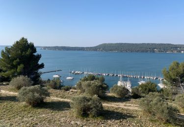
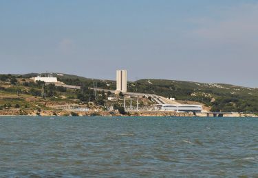
Circuit proposé par et au départ de l'Office de Tourisme d'Istres, 30 allée Jean Jaurès. Partez à la découverte du centre historique de la ville d'Istres. Du Portail d'Arles à l'église de Notre Dame de Beauvoir, arpentez les ruelles étroites et les facettes pittoresques du vieil Istres construit sur un banc calcaire abondant en huîtres fossilisées. Il s'agit d'une colline, dont la base forme un ovale d'environ 250 m sur 188 m, s'étendant du nord au sud, dominée par une éminence centrale de 30 m d'altitude. C'est un village perché sur un sommet rocheux, site caractéristique de lhabitat rural groupé méditerranéen. Les maisons se sont bâties à partir du château central selon un plan radio-concentrique. Ce lieu remplit d'histoires vous permettra de découvrir la ville d'Istres et d'avoir une vue de hauteur sur l'étang de l'Olivier et le jet d'eau le plus haut de France. Le temps du parcours dépend des visites des monuments et musées.
Plaatsbepaling
Opmerkingen
Wandeltochten in de omgeving
![Tocht Stappen Istres - Entre ville et nature - Istres - Photo](https://media.geolcdn.com/t/375/260/ext.jpg?maxdim=2&url=https%3A%2F%2Fservices.sitytrail.com%2FGeolivesWS%2FDownloadMedia.ashx%3FTrailID%3D191380%26Media%3D14948_6.jpg)
![Stappen Stappen](https://static1.geolcdn.com/sitytour/trail-icons/101.png)
Stappen
![](/images/other/stat-length.png)
![](https://static1.geolcdn.com/siteimages/upload/files/16400158638029165_repeat_loop_refresh_sync_direction_icon.png)
![Tocht Te voet Istres - Entre ville et nature (Istres) - Photo](https://media.geolcdn.com/t/375/260/c6b4632a-eacc-47f8-8cb4-22741d911e31.jpeg&format=jpg&maxdim=2)
![Te voet Te voet](https://static1.geolcdn.com/sitytour/trail-icons/100.png)
Te voet
![](/images/other/stat-length.png)
![](https://static1.geolcdn.com/siteimages/upload/files/16400158638029165_repeat_loop_refresh_sync_direction_icon.png)
![Tocht Stappen Istres - Miramas Istres GR 2013 ALLER - Photo](https://media.geolcdn.com/t/375/260/ext.jpg?maxdim=2&url=https%3A%2F%2Fstatic1.geolcdn.com%2Fsiteimages%2Fupload%2Ffiles%2F1553511878bg_sport_marche.png)
![Stappen Stappen](https://static1.geolcdn.com/sitytour/trail-icons/101.png)
Stappen
![](/images/other/stat-length.png)
![](https://static1.geolcdn.com/siteimages/upload/files/16400158638029165_repeat_loop_refresh_sync_direction_icon.png)
![Tocht Stappen Istres - Le Ranquet-Istres 30.11.24 - Photo](https://media.geolcdn.com/t/375/260/edae3387-dbd2-44f3-a355-b8e1e68c6a61.jpg&format=jpg&maxdim=2)
![Stappen Stappen](https://static1.geolcdn.com/sitytour/trail-icons/101.png)
Stappen
![](/images/other/stat-length.png)
![](https://static1.geolcdn.com/siteimages/upload/files/16400158638029165_repeat_loop_refresh_sync_direction_icon.png)
![Tocht Stappen Saint-Chamas - St Chamas la Touloubre - Photo](https://media.geolcdn.com/t/375/260/f9f7571a-d63b-4c1d-b704-b5de87e678de.jpg&format=jpg&maxdim=2)
![Stappen Stappen](https://static1.geolcdn.com/sitytour/trail-icons/101.png)
Stappen
![](/images/other/stat-length.png)
![](https://static1.geolcdn.com/siteimages/upload/files/16400158638029165_repeat_loop_refresh_sync_direction_icon.png)
![Tocht Stappen Istres - Martigues entre les étangs de Citis et Lavalduc - Photo](https://media.geolcdn.com/t/375/260/3676fb10-77ad-438e-9273-065789ad9a3e.jpg&format=jpg&maxdim=2)
![Stappen Stappen](https://static1.geolcdn.com/sitytour/trail-icons/101.png)
Stappen
![](/images/other/stat-length.png)
![](https://static1.geolcdn.com/siteimages/upload/files/16400158638029165_repeat_loop_refresh_sync_direction_icon.png)
![Tocht Stappen Saint-Chamas - St chamas - Photo](https://media.geolcdn.com/t/375/260/4cbc1327-bf0c-4677-b2ac-6b2dc9c3ea9b.jpg&format=jpg&maxdim=2)
![Stappen Stappen](https://static1.geolcdn.com/sitytour/trail-icons/101.png)
Stappen
![](/images/other/stat-length.png)
![](https://static1.geolcdn.com/siteimages/upload/files/16400158638029165_repeat_loop_refresh_sync_direction_icon.png)
![Tocht Te voet Saint-Chamas - La petite Camargue - Photo](https://media.geolcdn.com/t/375/260/a1645164-0975-4adb-8824-f0171283f613.jpeg&format=jpg&maxdim=2)
![Te voet Te voet](https://static1.geolcdn.com/sitytour/trail-icons/100.png)
Te voet
![](/images/other/stat-length.png)
![](https://static1.geolcdn.com/siteimages/upload/files/16400158638029165_repeat_loop_refresh_sync_direction_icon.png)
![Tocht Stappen Berre-l'Étang - St Chamas variante patrimoine - Photo](https://media.geolcdn.com/t/375/260/9d09f0ff-03c0-4c52-a69c-b23e93dcf329.jpg&format=jpg&maxdim=2)
![Stappen Stappen](https://static1.geolcdn.com/sitytour/trail-icons/101.png)
Stappen
![](/images/other/stat-length.png)
![](https://static1.geolcdn.com/siteimages/upload/files/16400158638029165_repeat_loop_refresh_sync_direction_icon.png)