![](/images/other/stat-length.png)
![Tocht Lopen Le Rove - Fort de Figuerolles - Le Rove - Photo](https://media.geolcdn.com/t/1900/400/ext.pjpeg?maxdim=2&url=https%3A%2F%2Fservices.sitytrail.com%2FGeolivesWS%2FDownloadMedia.ashx%3FTrailID%3D191339%26Media%3D14897_1.jpg)
Fort de Figuerolles - Le Rove
tracegps
Gebruiker
![Lengte](/images/other/stat-length.png)
![Max. hoogte](https://static1.geolcdn.com/siteimages/upload/files/1508320355ic_sort_altitude_max_24dp.png)
![Positief hoogteverschil](https://static1.geolcdn.com/siteimages/upload/files/1508320355ic_sort_den_pos_24dp.png)
![Km-Effort](/images/other/stat-length.png)
![Min. hoogte](https://static1.geolcdn.com/siteimages/upload/files/1508320355ic_sort_altitude_min_24dp.png)
![Negatief hoogteverschil](https://static1.geolcdn.com/siteimages/upload/files/1508320355ic_sort_den_neg_24dp.png)
![Boucle](https://static1.geolcdn.com/siteimages/upload/files/16400158638029165_repeat_loop_refresh_sync_direction_icon.png)
![Lopen](https://static1.geolcdn.com/sitytour/trail-icons/103.png)
1h19
Moeilijkheid : Moeilijk
![Scan deze QR-code om de tocht te openen in de SityTrail-applicatie](https://capi.geolives.com/qq0zvz2zws4bq2lad0pu/sitytour/trails/191339/qr.png?size=200)
Gratisgps-wandelapplicatie
Over ons
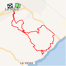
Tocht Lopen van 10,3 km beschikbaar op Provence-Alpes-Côte d'Azur, Bouches-du-Rhône, Le Rove. Deze tocht wordt voorgesteld door tracegps.
Beschrijving
Je vous propose d'attaquer maintenant la Chaîne de l'Estaque. Ce premier jogging nous emmène découvrir les ruines du Fort de Figuerolles avec en prime un superbe point de vue sur les îles du Frioul. De Marseille il faut prendre l'Autoroute du Littoral A 55, sortir au Rove, prendre la D 568 qui remonte le Vallon du Douard. Au rond point à l'entrée du Rove ne pas aller dans le centre ville. Le départ se fait à quelques mètres du petit centre commercial du Rove situé sur la D 568 juste au niveau du Chemin des Esclades. La remontée est parfois rude, ce qui malgré la distance modeste me le fait classer en "difficile".
Plaatsbepaling
Opmerkingen
Wandeltochten in de omgeving
![Tocht Stappen Le Rove - Calanque de la Vesse - Niolon la Vesse - Photo](https://media.geolcdn.com/t/375/260/ext.jpg?maxdim=2&url=https%3A%2F%2Fservices.sitytrail.com%2FGeolivesWS%2FDownloadMedia.ashx%3FTrailID%3D173014%26Media%3D14517_3.jpg)
![Stappen Stappen](https://static1.geolcdn.com/sitytour/trail-icons/101.png)
Stappen
![](/images/other/stat-length.png)
![](https://static1.geolcdn.com/siteimages/upload/files/16400158638029165_repeat_loop_refresh_sync_direction_icon.png)
![Tocht Stappen Marseille - Marseille Estaque à Redonne - Photo](https://media.geolcdn.com/t/375/260/340207fd-a5d2-463a-a208-d159b4a5061b.jpg&format=jpg&maxdim=2)
![Stappen Stappen](https://static1.geolcdn.com/sitytour/trail-icons/101.png)
Stappen
![](/images/other/stat-length.png)
![](https://static1.geolcdn.com/siteimages/upload/files/16400158638029165_repeat_loop_refresh_sync_direction_icon.png)
![Tocht Stappen Le Rove - Côté bleue - Photo](https://media.geolcdn.com/t/375/260/fb6332a1-2d00-4409-b098-eb5bb9797d34.jpg&format=jpg&maxdim=2)
![Stappen Stappen](https://static1.geolcdn.com/sitytour/trail-icons/101.png)
Stappen
![](/images/other/stat-length.png)
![](https://static1.geolcdn.com/siteimages/upload/files/16400158638029165_repeat_loop_refresh_sync_direction_icon.png)
![Tocht Te voet Ensuès-la-Redonne - Grand Sentier de la Côte Bleue - Photo](https://media.geolcdn.com/t/375/260/e6d2f765-bb75-419b-b14b-35c0d85ab7e2.jpeg&format=jpg&maxdim=2)
![Te voet Te voet](https://static1.geolcdn.com/sitytour/trail-icons/100.png)
Te voet
![](/images/other/stat-length.png)
![](https://static1.geolcdn.com/siteimages/upload/files/16400158638029165_repeat_loop_refresh_sync_direction_icon.png)
![Tocht Te voet Le Rove - Le fort de Niolon - Photo](https://media.geolcdn.com/t/375/260/93364f75-dc6d-4cba-b606-eb4abcda53d9.jpeg&format=jpg&maxdim=2)
![Te voet Te voet](https://static1.geolcdn.com/sitytour/trail-icons/100.png)
Te voet
![](/images/other/stat-length.png)
![](https://static1.geolcdn.com/siteimages/upload/files/16400158638029165_repeat_loop_refresh_sync_direction_icon.png)
![Tocht Stappen Le Rove - de Niolon à l'Erévine - Photo](https://media.geolcdn.com/t/375/260/4bb4e4f1-8064-4508-97a7-6fadcd44a858.jpg&format=jpg&maxdim=2)
![Stappen Stappen](https://static1.geolcdn.com/sitytour/trail-icons/101.png)
Stappen
![](/images/other/stat-length.png)
![](https://static1.geolcdn.com/siteimages/upload/files/16400158638029165_repeat_loop_refresh_sync_direction_icon.png)
![Tocht Stappen Le Rove - Cote bleue - Photo](https://media.geolcdn.com/t/375/260/ext.jpg?maxdim=2&url=https%3A%2F%2Fservices.sitytrail.com%2FGeolivesWS%2FDownloadMedia.ashx%3FTrailID%3D1137457%26Media%3Dfix__20190421151733.jpg)
![Stappen Stappen](https://static1.geolcdn.com/sitytour/trail-icons/101.png)
Stappen
![](/images/other/stat-length.png)
![](https://static1.geolcdn.com/siteimages/upload/files/16400158638029165_repeat_loop_refresh_sync_direction_icon.png)
![Tocht Stappen Le Rove - le Rove - Photo](https://media.geolcdn.com/t/375/260/a57a04ed-8c7b-414d-b81a-6cd022e3b570.jpeg&format=jpg&maxdim=2)
![Stappen Stappen](https://static1.geolcdn.com/sitytour/trail-icons/101.png)
Stappen
![](/images/other/stat-length.png)
![](https://static1.geolcdn.com/siteimages/upload/files/16400158638029165_repeat_loop_refresh_sync_direction_icon.png)
![Tocht Stappen Marseille - Sausset les Pins - Marseille - Photo](https://media.geolcdn.com/t/375/260/ext.jpg?maxdim=2&url=https%3A%2F%2Fstatic1.geolcdn.com%2Fsiteimages%2Fupload%2Ffiles%2F1553511878bg_sport_marche.png)
![Stappen Stappen](https://static1.geolcdn.com/sitytour/trail-icons/101.png)
Stappen
![](/images/other/stat-length.png)
![](https://static1.geolcdn.com/siteimages/upload/files/16400158638029165_repeat_loop_refresh_sync_direction_icon.png)