Tocht Fiets Villefort - Villefort Aubenas - Photo

Villefort Aubenas

 biollay
biollay

Gebruiker

© OpenStreetMap contributors
Lengte
Lengte
103 km
Max. hoogte
Max. hoogte
1196 m
Positief hoogteverschil
2538 m
Km-Effort
Km-Effort  
138 km
Min. hoogte
Min. hoogte
268 m
Negatief hoogteverschil
2897 m
Boucle
Boucle
Neen
Datum van aanmaak :
2019-06-29 13:11:38.671
Laatste wijziging :
2019-06-29 13:11:43.175

(0 Bericht)

Fiets
Fiets
4h56
Moeilijkheid : Medium

Scan deze QR-code om de tocht te openen in de SityTrail-applicatie

Gratisgps-wandelapplicatie

Logo SityTrail SityTrail

IGN / Geografische instituten

SityTrail uit de App Store downloaden SityTrail uit Google Play downloaden

Logo SityTrail SityTrail World

De wereld gaat voor u open

SityTrail uit de App Store downloaden SityTrail uit Google Play downloaden SityTrail op Huawei AppGallery downloaden

Over ons

Tocht Fiets van 103 km beschikbaar op Occitanië, Lozère, Villefort. Deze tocht wordt voorgesteld door biollay.

Beschrijving

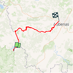
Petites routes de l'ardèche à vélo

Hoogteprofiel

Plaatsbepaling

Land:
France
Regio :
Occitanië
Departement/Provincie :
Lozère
Gemeente :
Villefort
Locatie:
Unknown
Vertrek:(Dec)
Vertrek:(UTM)
574264 ; 4920354 (31T) N.

Wandeltochten in de omgeving

Tocht Stappen Pied-de-Borne - GRP Tour du Chassezac en 2 jours - Photo
Stappen
GUIDE
nadinebondoux

Stappen

Moeilijk
Pied-de-Borne, Occitanië, Lozère, France
25 km | 36 km-effort
6h 50min
Neen
Tocht Te voet Malons-et-Elze - GR 44 - Photo
Te voet
PRO

Te voet

Gemakkelijk
Malons-et-Elze, Occitanië, Gard, France
4,8 km | 6,4 km-effort
1h 26min
Neen
Tocht Stappen Ponteils-et-Brésis - Nord haute Vallee de la Cèze - Photo
Stappen
GUIDE
nadinebondoux

Stappen

Moeilijk
Ponteils-et-Brésis, Occitanië, Gard, France
23 km | 34 km-effort
6h 50min
Ja
Tocht Stappen Ponteils-et-Brésis - Bour a es - Photo
Stappen
GUIDE
Roger Philippe Wallez

Stappen

Zeer moeilijk
Ponteils-et-Brésis, Occitanië, Gard, France
24 km | 36 km-effort
7h 37min
Ja
Tocht Stappen Pied-de-Borne - Le tour du Chassezac  - Photo
Stappen
GUIDE
Roger Philippe Wallez

Stappen

Zeer moeilijk
Pied-de-Borne, Occitanië, Lozère, France
49 km | 72 km-effort
37h 28min
Ja
Tocht Stappen Pied-de-Borne - Le tour du chassezac - Photo
Stappen
GUIDE
Roger Philippe Wallez

Stappen

Zeer moeilijk
Pied-de-Borne, Occitanië, Lozère, France
49 km | 72 km-effort
16h 34min
Ja
Tocht Stappen Pourcharesses - tour du lac de Villefort et chapelle Saint Loup.  - Photo
Stappen
dcharbonnier

Stappen

Gemakkelijk
Pourcharesses, Occitanië, Lozère, France
9 km | 12,8 km-effort
3h 53min
Neen
Tocht Stappen Villefort - Tour du lac de villefort  - Photo
Stappen
Gegetop

Stappen

Gemakkelijk
Villefort, Occitanië, Lozère, France
8,1 km | 11,6 km-effort
2h 6min
Ja
Tocht Stappen Villefort - Lac Villefort la Garde Guerin, lac de Villefort.(31-05-2020) - Photo
Stappen
jesusmarieclaire

Stappen

Medium
(1)
Villefort, Occitanië, Lozère, France
15,1 km | 21 km-effort
4h 26min
Ja


Sluiten
Mijn abonnementen