![](/images/other/stat-length.png)
![Tocht Wintersport Val-de-Charmey - La Berra - Photo](https://media.geolcdn.com/t/1900/400/ext.pjpeg?maxdim=2&url=https%3A%2F%2Fstatic1.geolcdn.com%2Fsiteimages%2Fupload%2Ffiles%2F1524743153ski.jpg)
La Berra
Marginal
Gebruiker
![Lengte](/images/other/stat-length.png)
Lengte
27 km
![Max. hoogte](https://static1.geolcdn.com/siteimages/upload/files/1508320355ic_sort_altitude_max_24dp.png)
Max. hoogte
1676 m
![Positief hoogteverschil](https://static1.geolcdn.com/siteimages/upload/files/1508320355ic_sort_den_pos_24dp.png)
Positief hoogteverschil
1277 m
![Km-Effort](/images/other/stat-length.png)
Km-Effort
44 km
![Min. hoogte](https://static1.geolcdn.com/siteimages/upload/files/1508320355ic_sort_altitude_min_24dp.png)
Min. hoogte
888 m
![Negatief hoogteverschil](https://static1.geolcdn.com/siteimages/upload/files/1508320355ic_sort_den_neg_24dp.png)
Negatief hoogteverschil
1273 m
![Boucle](https://static1.geolcdn.com/siteimages/upload/files/16400158638029165_repeat_loop_refresh_sync_direction_icon.png)
Boucle
Ja
Datum van aanmaak :
2014-12-11 00:00:00.0
Laatste wijziging :
2014-12-11 00:00:00.0
![Wintersport](https://static1.geolcdn.com/sitytour/trail-icons/500.png)
--
Moeilijkheid : Onbekend
![Scan deze QR-code om de tocht te openen in de SityTrail-applicatie](https://capi.geolives.com/qq0zvz2zws4bq2lad0pu/sitytour/trails/18845/qr.png?size=200)
Gratisgps-wandelapplicatie
Over ons
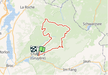
Tocht Wintersport van 27 km beschikbaar op Fribourg/Freiburg, District de la Gruyère, Val-de-Charmey. Deze tocht wordt voorgesteld door Marginal.
Beschrijving
Depuis Charmey, "échauffement" jusqu''à la Valsainte avant la montée de la Berra. Descente puis montée vers les dents vertes interrompue pour descendre par un petit chemin direction Charmey.
Plaatsbepaling
Land:
Switzerland
Regio :
Fribourg/Freiburg
Departement/Provincie :
District de la Gruyère
Gemeente :
Val-de-Charmey
Locatie:
Unknown
Vertrek:(Dec)
Vertrek:(UTM)
359428 ; 5164538 (32T) N.
Opmerkingen
Wandeltochten in de omgeving
![Tocht Noords wandelen Val-de-Charmey - Treek charmey au lac noir. - Photo](https://media.geolcdn.com/t/375/260/c3daf44f-29a6-4be1-822b-7f9c2cadf768.jpg&format=jpg&maxdim=2)
![Noords wandelen Noords wandelen](https://static1.geolcdn.com/sitytour/trail-icons/102.png)
Treek charmey au lac noir.
Noords wandelen
Gemakkelijk
Val-de-Charmey,
Fribourg/Freiburg,
District de la Gruyère,
Switzerland
![](/images/other/stat-length.png)
21 km | 33 km-effort
5h 4min
![](https://static1.geolcdn.com/siteimages/upload/files/16400158638029165_repeat_loop_refresh_sync_direction_icon.png)
Ja
![Tocht Mountainbike Val-de-Charmey - La Berra - Photo](https://media.geolcdn.com/t/375/260/ext.jpg?maxdim=2&url=https%3A%2F%2Fstatic1.geolcdn.com%2Fsiteimages%2Fupload%2Ffiles%2F1524743154velo.jpg)
![Mountainbike Mountainbike](https://static1.geolcdn.com/sitytour/trail-icons/202.png)
La Berra
Mountainbike
Heel gemakkelijk
Val-de-Charmey,
Fribourg/Freiburg,
District de la Gruyère,
Switzerland
![](/images/other/stat-length.png)
30 km | 44 km-effort
10h 0min
![](https://static1.geolcdn.com/siteimages/upload/files/16400158638029165_repeat_loop_refresh_sync_direction_icon.png)
Ja
![Tocht Stappen Val-de-Charmey - Charmey: Tolle Rundsichten von Vounetse - Photo](https://media.geolcdn.com/t/375/260/ext.jpg?maxdim=2&url=https%3A%2F%2Fstatic1.geolcdn.com%2Fsiteimages%2Fupload%2Ffiles%2F1553511878bg_sport_marche.png)
![Stappen Stappen](https://static1.geolcdn.com/sitytour/trail-icons/101.png)
Charmey: Tolle Rundsichten von Vounetse
Stappen
Heel gemakkelijk
Val-de-Charmey,
Fribourg/Freiburg,
District de la Gruyère,
Switzerland
![](/images/other/stat-length.png)
7,4 km | 17 km-effort
Onbekend
![](https://static1.geolcdn.com/siteimages/upload/files/16400158638029165_repeat_loop_refresh_sync_direction_icon.png)
Neen
![Tocht Mountainbike Val-de-Charmey - Bike32902 - Photo](https://media.geolcdn.com/t/375/260/ext.jpg?maxdim=2&url=https%3A%2F%2Fstatic1.geolcdn.com%2Fsiteimages%2Fupload%2Ffiles%2F1524743154velo.jpg)
![Mountainbike Mountainbike](https://static1.geolcdn.com/sitytour/trail-icons/202.png)
Bike32902
Mountainbike
Heel gemakkelijk
Val-de-Charmey,
Fribourg/Freiburg,
District de la Gruyère,
Switzerland
![](/images/other/stat-length.png)
21 km | 31 km-effort
Onbekend
![](https://static1.geolcdn.com/siteimages/upload/files/16400158638029165_repeat_loop_refresh_sync_direction_icon.png)
Ja
![Tocht Andere activiteiten Val-de-Charmey - w10_04_gruyere - Photo](https://media.geolcdn.com/t/375/260/ext.jpg?maxdim=2&url=https%3A%2F%2Fstatic1.geolcdn.com%2Fsiteimages%2Fupload%2Ffiles%2F1545311037marcheuse_200dpi.jpg)
![Andere activiteiten Andere activiteiten](https://static1.geolcdn.com/sitytour/trail-icons/900.png)
w10_04_gruyere
Andere activiteiten
Heel gemakkelijk
Val-de-Charmey,
Fribourg/Freiburg,
District de la Gruyère,
Switzerland
![](/images/other/stat-length.png)
10,8 km | 14,8 km-effort
3h 53min
![](https://static1.geolcdn.com/siteimages/upload/files/16400158638029165_repeat_loop_refresh_sync_direction_icon.png)
Neen
![Tocht Stappen Val-de-Charmey - Charmey - La Valsainte 26.06.18 - Photo](https://media.geolcdn.com/t/375/260/ext.jpg?maxdim=2&url=https%3A%2F%2Fservices.sitytrail.com%2FGeolivesWS%2FDownloadMedia.ashx%3FTrailID%3D994107%26Media%3D92dc41ad-9397-4a09-9ba0-6ccf73d6d981.jpg)
![Stappen Stappen](https://static1.geolcdn.com/sitytour/trail-icons/101.png)
Charmey - La Valsainte 26.06.18
Stappen
Gemakkelijk
Val-de-Charmey,
Fribourg/Freiburg,
District de la Gruyère,
Switzerland
![](/images/other/stat-length.png)
11,6 km | 15,7 km-effort
3h 21min
![](https://static1.geolcdn.com/siteimages/upload/files/16400158638029165_repeat_loop_refresh_sync_direction_icon.png)
Ja
![Tocht Stappen Val-de-Charmey - Charmey René - Photo](https://media.geolcdn.com/t/375/260/ext.jpg?maxdim=2&url=https%3A%2F%2Fstatic1.geolcdn.com%2Fsiteimages%2Fupload%2Ffiles%2F1553511878bg_sport_marche.png)
![Stappen Stappen](https://static1.geolcdn.com/sitytour/trail-icons/101.png)
Charmey René
Stappen
Gemakkelijk
Val-de-Charmey,
Fribourg/Freiburg,
District de la Gruyère,
Switzerland
![](/images/other/stat-length.png)
6,4 km | 9,2 km-effort
1h 56min
![](https://static1.geolcdn.com/siteimages/upload/files/16400158638029165_repeat_loop_refresh_sync_direction_icon.png)
Ja
![Tocht Stappen Broc - Gorges de la Jogne, lac de Montsalvens circuit 07.04.17 - Photo](https://media.geolcdn.com/t/375/260/ext.jpg?maxdim=2&url=https%3A%2F%2Fservices.sitytrail.com%2FGeolivesWS%2FDownloadMedia.ashx%3FTrailID%3D728333%26Media%3D6d1987d7-f8ac-4d38-94c7-1c3fdbb4f749.jpg)
![Stappen Stappen](https://static1.geolcdn.com/sitytour/trail-icons/101.png)
Gorges de la Jogne, lac de Montsalvens circuit 07.04.17
Stappen
Medium
Broc,
Fribourg/Freiburg,
District de la Gruyère,
Switzerland
![](/images/other/stat-length.png)
12,6 km | 19 km-effort
4h 17min
![](https://static1.geolcdn.com/siteimages/upload/files/16400158638029165_repeat_loop_refresh_sync_direction_icon.png)
Ja
![Tocht Stappen Corbières - Corbières-Impart-Le Ruz-Hauteville - Photo](https://media.geolcdn.com/t/375/260/ext.jpg?maxdim=2&url=https%3A%2F%2Fstatic1.geolcdn.com%2Fsiteimages%2Fupload%2Ffiles%2F1553511878bg_sport_marche.png)
![Stappen Stappen](https://static1.geolcdn.com/sitytour/trail-icons/101.png)
Corbières-Impart-Le Ruz-Hauteville
Stappen
Medium
Corbières,
Fribourg/Freiburg,
District de la Gruyère,
Switzerland
![](/images/other/stat-length.png)
7,8 km | 10,8 km-effort
2h 27min
![](https://static1.geolcdn.com/siteimages/upload/files/16400158638029165_repeat_loop_refresh_sync_direction_icon.png)
Ja