![](/images/other/stat-length.png)
![Tocht Andere activiteiten Orsières - Col des Ecandies - Photo](https://media.geolcdn.com/t/1900/400/ext.pjpeg?maxdim=2&url=https%3A%2F%2Fstatic1.geolcdn.com%2Fsiteimages%2Fupload%2Ffiles%2F1545311037marcheuse_200dpi.jpg)
Col des Ecandies
pnoth
Gebruiker
![Lengte](/images/other/stat-length.png)
Lengte
5,6 km
![Max. hoogte](https://static1.geolcdn.com/siteimages/upload/files/1508320355ic_sort_altitude_max_24dp.png)
Max. hoogte
2792 m
![Positief hoogteverschil](https://static1.geolcdn.com/siteimages/upload/files/1508320355ic_sort_den_pos_24dp.png)
Positief hoogteverschil
1156 m
![Km-Effort](/images/other/stat-length.png)
Km-Effort
17,2 km
![Min. hoogte](https://static1.geolcdn.com/siteimages/upload/files/1508320355ic_sort_altitude_min_24dp.png)
Min. hoogte
1633 m
![Negatief hoogteverschil](https://static1.geolcdn.com/siteimages/upload/files/1508320355ic_sort_den_neg_24dp.png)
Negatief hoogteverschil
5 m
![Boucle](https://static1.geolcdn.com/siteimages/upload/files/16400158638029165_repeat_loop_refresh_sync_direction_icon.png)
Boucle
Neen
Datum van aanmaak :
2014-12-11 00:00:00.0
Laatste wijziging :
2014-12-11 00:00:00.0
![Andere activiteiten](https://static1.geolcdn.com/sitytour/trail-icons/900.png)
--
Moeilijkheid : Onbekend
![Scan deze QR-code om de tocht te openen in de SityTrail-applicatie](https://capi.geolives.com/qq0zvz2zws4bq2lad0pu/sitytour/trails/18714/qr.png?size=200)
Gratisgps-wandelapplicatie
Over ons
Tocht Andere activiteiten van 5,6 km beschikbaar op Valais/Wallis, Entremont, Orsières. Deze tocht wordt voorgesteld door pnoth.
Beschrijving
English: http://www.noth.ch/h0136_e.html
Français: http://www.noth.ch/h0136_f.html
Deutsch: http://www.noth.ch/h0136_d.html
Plaatsbepaling
Land:
Switzerland
Regio :
Valais/Wallis
Departement/Provincie :
Entremont
Gemeente :
Orsières
Locatie:
Unknown
Vertrek:(Dec)
Vertrek:(UTM)
352447 ; 5099112 (32T) N.
Opmerkingen
Wandeltochten in de omgeving
![Tocht Te voet Orsières - Chemins pédestre de montagne, commune d'Orsières - Photo](https://media.geolcdn.com/t/375/260/6dfeee0d-887b-4c9c-aefd-3dcd0ea22569.jpeg&format=jpg&maxdim=2)
![Te voet Te voet](https://static1.geolcdn.com/sitytour/trail-icons/100.png)
Chemins pédestre de montagne, commune d'Orsières
Te voet
Gemakkelijk
Orsières,
Valais/Wallis,
Entremont,
Switzerland
![](/images/other/stat-length.png)
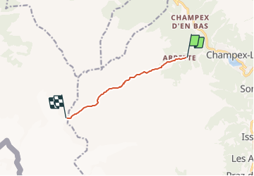
5,6 km | 8,8 km-effort
1h 59min
![](https://static1.geolcdn.com/siteimages/upload/files/16400158638029165_repeat_loop_refresh_sync_direction_icon.png)
Neen
![Tocht Te voet Orsières - sentier du Devin - Photo](https://media.geolcdn.com/t/375/260/1486fc85-352e-404e-b600-0f3d7bac1924.jpeg&format=jpg&maxdim=2)
![Te voet Te voet](https://static1.geolcdn.com/sitytour/trail-icons/100.png)
sentier du Devin
Te voet
Gemakkelijk
Orsières,
Valais/Wallis,
Entremont,
Switzerland
![](/images/other/stat-length.png)
3,9 km | 6,7 km-effort
1h 31min
![](https://static1.geolcdn.com/siteimages/upload/files/16400158638029165_repeat_loop_refresh_sync_direction_icon.png)
Ja
![Tocht Te voet Orsières - Chemins pédestre, commune d'Orsières - Photo](https://media.geolcdn.com/t/375/260/70edd484-9073-4e02-96d0-3d17425bab34.jpeg&format=jpg&maxdim=2)
![Te voet Te voet](https://static1.geolcdn.com/sitytour/trail-icons/100.png)
Chemins pédestre, commune d'Orsières
Te voet
Gemakkelijk
Orsières,
Valais/Wallis,
Entremont,
Switzerland
![](/images/other/stat-length.png)
5,4 km | 14,1 km-effort
3h 12min
![](https://static1.geolcdn.com/siteimages/upload/files/16400158638029165_repeat_loop_refresh_sync_direction_icon.png)
Neen
![Tocht Te voet Bovernier - Chemins pédestre de montagne, région Entremont - Photo](https://media.geolcdn.com/t/375/260/8965cd81-5f88-4628-9726-209c4b98c789.jpeg&format=jpg&maxdim=2)
![Te voet Te voet](https://static1.geolcdn.com/sitytour/trail-icons/100.png)
Chemins pédestre de montagne, région Entremont
Te voet
Medium
Bovernier,
Valais/Wallis,
Martigny,
Switzerland
![](/images/other/stat-length.png)
6,9 km | 22 km-effort
4h 54min
![](https://static1.geolcdn.com/siteimages/upload/files/16400158638029165_repeat_loop_refresh_sync_direction_icon.png)
Neen
![Tocht Te voet Orsières - Raccard du blé - Photo](https://media.geolcdn.com/t/375/260/e3af305e-4edc-4919-bcad-22d8b69ac232.jpeg&format=jpg&maxdim=2)
![Te voet Te voet](https://static1.geolcdn.com/sitytour/trail-icons/100.png)
Raccard du blé
Te voet
Gemakkelijk
Orsières,
Valais/Wallis,
Entremont,
Switzerland
![](/images/other/stat-length.png)
7,9 km | 13,7 km-effort
3h 6min
![](https://static1.geolcdn.com/siteimages/upload/files/16400158638029165_repeat_loop_refresh_sync_direction_icon.png)
Ja
![Tocht Stappen Orsières - TMB 08 - Relais d'Arpette -> Trient - Photo](https://media.geolcdn.com/t/375/260/879d1358-40ae-4393-aa0f-3cd2dbd6e081.jpg&format=jpg&maxdim=2)
![Stappen Stappen](https://static1.geolcdn.com/sitytour/trail-icons/101.png)
TMB 08 - Relais d'Arpette -> Trient
Stappen
Moeilijk
Orsières,
Valais/Wallis,
Entremont,
Switzerland
![](/images/other/stat-length.png)
17 km | 28 km-effort
6h 39min
![](https://static1.geolcdn.com/siteimages/upload/files/16400158638029165_repeat_loop_refresh_sync_direction_icon.png)
Neen
![Tocht Sneeuwschoenen Orsières - Champex Lac - La Breya - Champex Lac - Photo](https://media.geolcdn.com/t/375/260/6555df26-5e72-41d3-9ea4-2761199f667f.jpg&format=jpg&maxdim=2)
![Sneeuwschoenen Sneeuwschoenen](https://static1.geolcdn.com/sitytour/trail-icons/504.png)
Champex Lac - La Breya - Champex Lac
Sneeuwschoenen
Medium
Orsières,
Valais/Wallis,
Entremont,
Switzerland
![](/images/other/stat-length.png)
8,8 km | 18,2 km-effort
3h 1min
![](https://static1.geolcdn.com/siteimages/upload/files/16400158638029165_repeat_loop_refresh_sync_direction_icon.png)
Ja
![Tocht Stappen Orsières - CMX ZRMT Étape 2 Champex Cabane de Mille - Photo](https://media.geolcdn.com/t/375/260/ext.jpg?maxdim=2&url=https%3A%2F%2Fservices.sitytrail.com%2FGeolivesWS%2FDownloadMedia.ashx%3FTrailID%3D635928%26Media%3Dfix__20160914135625.jpg)
![Stappen Stappen](https://static1.geolcdn.com/sitytour/trail-icons/101.png)
CMX ZRMT Étape 2 Champex Cabane de Mille
Stappen
Medium
Orsières,
Valais/Wallis,
Entremont,
Switzerland
![](/images/other/stat-length.png)
17,9 km | 38 km-effort
7h 15min
![](https://static1.geolcdn.com/siteimages/upload/files/16400158638029165_repeat_loop_refresh_sync_direction_icon.png)
Neen
![Tocht Stappen Orsières - TMB day 5 - Photo](https://media.geolcdn.com/t/375/260/ext.jpg?maxdim=2&url=https%3A%2F%2Fservices.sitytrail.com%2FGeolivesWS%2FDownloadMedia.ashx%3FTrailID%3D477598%26Media%3D393e1b86-eaa0-4b2d-a1d7-a6d5bce0c2e5.jpg)
![Stappen Stappen](https://static1.geolcdn.com/sitytour/trail-icons/101.png)
TMB day 5
Stappen
Medium
Orsières,
Valais/Wallis,
Entremont,
Switzerland
![](/images/other/stat-length.png)
16,7 km | 28 km-effort
6h 15min
![](https://static1.geolcdn.com/siteimages/upload/files/16400158638029165_repeat_loop_refresh_sync_direction_icon.png)
Neen