![](/images/other/stat-length.png)
![Tocht Andere activiteiten Villeneuve-de-la-Raho - Villeneuve de la Raho - Photo](https://media.geolcdn.com/t/1900/400/ext.pjpeg?maxdim=2&url=https%3A%2F%2Fservices.sitytrail.com%2FGeolivesWS%2FDownloadMedia.ashx%3FTrailID%3D186503%26Media%3D20130421095712.jpg)
Villeneuve de la Raho
perittel
Gebruiker
![Lengte](/images/other/stat-length.png)
Lengte
16,1 km
![Max. hoogte](https://static1.geolcdn.com/siteimages/upload/files/1508320355ic_sort_altitude_max_24dp.png)
Max. hoogte
40 m
![Positief hoogteverschil](https://static1.geolcdn.com/siteimages/upload/files/1508320355ic_sort_den_pos_24dp.png)
Positief hoogteverschil
118 m
![Km-Effort](/images/other/stat-length.png)
Km-Effort
17,6 km
![Min. hoogte](https://static1.geolcdn.com/siteimages/upload/files/1508320355ic_sort_altitude_min_24dp.png)
Min. hoogte
6 m
![Negatief hoogteverschil](https://static1.geolcdn.com/siteimages/upload/files/1508320355ic_sort_den_neg_24dp.png)
Negatief hoogteverschil
117 m
![Boucle](https://static1.geolcdn.com/siteimages/upload/files/16400158638029165_repeat_loop_refresh_sync_direction_icon.png)
Boucle
Ja
Datum van aanmaak :
2014-12-10 00:00:00.0
Laatste wijziging :
2014-12-10 00:00:00.0
![Andere activiteiten](https://static1.geolcdn.com/sitytour/trail-icons/900.png)
3h48
Moeilijkheid : Gemakkelijk
![Scan deze QR-code om de tocht te openen in de SityTrail-applicatie](https://capi.geolives.com/qq0zvz2zws4bq2lad0pu/sitytour/trails/186503/qr.png?size=200)
Gratisgps-wandelapplicatie
Over ons
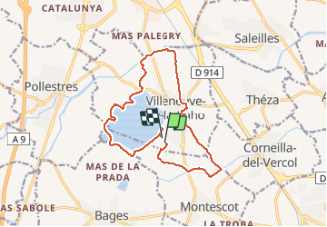
Tocht Andere activiteiten van 16,1 km beschikbaar op Occitanië, Pyrénées-Orientales, Villeneuve-de-la-Raho. Deze tocht wordt voorgesteld door perittel.
Beschrijving
Circuit de 16 km autour de Villeneuve de la Raho,proposé lors de la fête de la Randonnée 2013.
Plaatsbepaling
Land:
France
Regio :
Occitanië
Departement/Provincie :
Pyrénées-Orientales
Gemeente :
Villeneuve-de-la-Raho
Locatie:
Unknown
Vertrek:(Dec)
Vertrek:(UTM)
492955 ; 4719349 (31T) N.
Opmerkingen
Wandeltochten in de omgeving
![Tocht Quad Montescot - Villeneuve-de-la-Raho-Collioure (Septembre/Juin) - Photo](https://media.geolcdn.com/t/375/260/4ff70784-96c3-45ae-a310-36bc0ac2c85e.jpg&format=jpg&maxdim=2)
![Quad Quad](https://static1.geolcdn.com/sitytour/trail-icons/404.png)
Villeneuve-de-la-Raho-Collioure (Septembre/Juin)
Quad
Medium
(1)
Montescot,
Occitanië,
Pyrénées-Orientales,
France
![](/images/other/stat-length.png)
33 km | 40 km-effort
1h 45min
![](https://static1.geolcdn.com/siteimages/upload/files/16400158638029165_repeat_loop_refresh_sync_direction_icon.png)
Neen
![Tocht Stappen Montescot - 66 VILLENEUVE-DE-LA-RAHO grand tour du lac en Sens horaire - Photo](https://media.geolcdn.com/t/375/260/ext.jpg?maxdim=2&url=https%3A%2F%2Fservices.sitytrail.com%2FGeolivesWS%2FDownloadMedia.ashx%3FTrailID%3D526864%26Media%3D20160209171243.jpg)
![Stappen Stappen](https://static1.geolcdn.com/sitytour/trail-icons/101.png)
66 VILLENEUVE-DE-LA-RAHO grand tour du lac en Sens horaire
Stappen
Gemakkelijk
(1)
Montescot,
Occitanië,
Pyrénées-Orientales,
France
![](/images/other/stat-length.png)
6,7 km | 7,5 km-effort
1h 4min
![](https://static1.geolcdn.com/siteimages/upload/files/16400158638029165_repeat_loop_refresh_sync_direction_icon.png)
Ja
![Tocht Stappen Théza - 66 THEZA - CORNEILLA-DEL-VERCOL - Photo](https://media.geolcdn.com/t/375/260/ext.jpg?maxdim=2&url=https%3A%2F%2Fservices.sitytrail.com%2FGeolivesWS%2FDownloadMedia.ashx%3FTrailID%3D460837%26Media%3D20150818162338.jpg)
![Stappen Stappen](https://static1.geolcdn.com/sitytour/trail-icons/101.png)
66 THEZA - CORNEILLA-DEL-VERCOL
Stappen
Gemakkelijk
(2)
Théza,
Occitanië,
Pyrénées-Orientales,
France
![](/images/other/stat-length.png)
7 km | 7,5 km-effort
1h 8min
![](https://static1.geolcdn.com/siteimages/upload/files/16400158638029165_repeat_loop_refresh_sync_direction_icon.png)
Ja
![Tocht Stappen Saint-Jean-Lasseille - ST-JEAN-LASSEILLE 66 - terroirs des Aspres - Photo](https://media.geolcdn.com/t/375/260/ext.jpg?maxdim=2&url=https%3A%2F%2Fservices.sitytrail.com%2FGeolivesWS%2FDownloadMedia.ashx%3FTrailID%3D419934%26Media%3D20150512183916.jpg)
![Stappen Stappen](https://static1.geolcdn.com/sitytour/trail-icons/101.png)
ST-JEAN-LASSEILLE 66 - terroirs des Aspres
Stappen
Gemakkelijk
(1)
Saint-Jean-Lasseille,
Occitanië,
Pyrénées-Orientales,
France
![](/images/other/stat-length.png)
12,2 km | 14,3 km-effort
2h 6min
![](https://static1.geolcdn.com/siteimages/upload/files/16400158638029165_repeat_loop_refresh_sync_direction_icon.png)
Ja
![Tocht Stappen Villeneuve-de-la-Raho - 66 VILLENEUVE-DE-LA-RAHO - grand tour périphérique du lac par les lignes de crêtes - Photo](https://media.geolcdn.com/t/375/260/ext.jpg?maxdim=2&url=https%3A%2F%2Fstatic1.geolcdn.com%2Fsiteimages%2Fupload%2Ffiles%2F1553511878bg_sport_marche.png)
![Stappen Stappen](https://static1.geolcdn.com/sitytour/trail-icons/101.png)
66 VILLENEUVE-DE-LA-RAHO - grand tour périphérique du lac par les lignes de c...
Stappen
Gemakkelijk
(2)
Villeneuve-de-la-Raho,
Occitanië,
Pyrénées-Orientales,
France
![](/images/other/stat-length.png)
10 km | 11,5 km-effort
1h 44min
![](https://static1.geolcdn.com/siteimages/upload/files/16400158638029165_repeat_loop_refresh_sync_direction_icon.png)
Ja
![Tocht Stappen Saleilles - 66 SALEILLES - St-NAZAIRE, entre FOSSEILLE et REART - Photo](https://media.geolcdn.com/t/375/260/ext.jpg?maxdim=2&url=https%3A%2F%2Fstatic1.geolcdn.com%2Fsiteimages%2Fupload%2Ffiles%2F1553511878bg_sport_marche.png)
![Stappen Stappen](https://static1.geolcdn.com/sitytour/trail-icons/101.png)
66 SALEILLES - St-NAZAIRE, entre FOSSEILLE et REART
Stappen
Gemakkelijk
(1)
Saleilles,
Occitanië,
Pyrénées-Orientales,
France
![](/images/other/stat-length.png)
7,3 km | 7,7 km-effort
1h 8min
![](https://static1.geolcdn.com/siteimages/upload/files/16400158638029165_repeat_loop_refresh_sync_direction_icon.png)
Ja
![Tocht Stappen Saint-Nazaire - Soleil les mas guillemet - Photo](https://media.geolcdn.com/t/375/260/4435fc64-1ecd-43d7-8117-3a18aa9126a8.jpg&format=jpg&maxdim=2)
![Stappen Stappen](https://static1.geolcdn.com/sitytour/trail-icons/101.png)
Soleil les mas guillemet
Stappen
Medium
Saint-Nazaire,
Occitanië,
Pyrénées-Orientales,
France
![](/images/other/stat-length.png)
8,3 km | 8,7 km-effort
2h 52min
![](https://static1.geolcdn.com/siteimages/upload/files/16400158638029165_repeat_loop_refresh_sync_direction_icon.png)
Ja
![Tocht Stappen Saint-Nazaire - m'as d allo - Photo](https://media.geolcdn.com/t/375/260/df30209d-6615-45d8-a096-cf7c9cd8efda.jpg&format=jpg&maxdim=2)
![Stappen Stappen](https://static1.geolcdn.com/sitytour/trail-icons/101.png)
m'as d allo
Stappen
Medium
Saint-Nazaire,
Occitanië,
Pyrénées-Orientales,
France
![](/images/other/stat-length.png)
8,5 km | 9,2 km-effort
2h 51min
![](https://static1.geolcdn.com/siteimages/upload/files/16400158638029165_repeat_loop_refresh_sync_direction_icon.png)
Ja
![Tocht Quad Villeneuve-de-la-Raho - Villeneuve-de-la-Raho-Collioure(Juillet-Aout) - Photo](https://media.geolcdn.com/t/375/260/94b9111a-30bb-4d36-9ee6-84d7d83dae26.jpg&format=jpg&maxdim=2)
![Quad Quad](https://static1.geolcdn.com/sitytour/trail-icons/404.png)
Villeneuve-de-la-Raho-Collioure(Juillet-Aout)
Quad
Heel gemakkelijk
(1)
Villeneuve-de-la-Raho,
Occitanië,
Pyrénées-Orientales,
France
![](/images/other/stat-length.png)
39 km | 44 km-effort
1h 40min
![](https://static1.geolcdn.com/siteimages/upload/files/16400158638029165_repeat_loop_refresh_sync_direction_icon.png)
Neen