![](/images/other/stat-length.png)
![Tocht Andere activiteiten Vouvry - Cornettes de Bise (2''432 m) - par la Suisse - Photo](https://media.geolcdn.com/t/1900/400/ext.pjpeg?maxdim=2&url=https%3A%2F%2Fstatic1.geolcdn.com%2Fsiteimages%2Fupload%2Ffiles%2F1545311037marcheuse_200dpi.jpg)
Cornettes de Bise (2''432 m) - par la Suisse
Romrando
Gebruiker
![Lengte](/images/other/stat-length.png)
![Max. hoogte](https://static1.geolcdn.com/siteimages/upload/files/1508320355ic_sort_altitude_max_24dp.png)
![Positief hoogteverschil](https://static1.geolcdn.com/siteimages/upload/files/1508320355ic_sort_den_pos_24dp.png)
![Km-Effort](/images/other/stat-length.png)
![Min. hoogte](https://static1.geolcdn.com/siteimages/upload/files/1508320355ic_sort_altitude_min_24dp.png)
![Negatief hoogteverschil](https://static1.geolcdn.com/siteimages/upload/files/1508320355ic_sort_den_neg_24dp.png)
![Boucle](https://static1.geolcdn.com/siteimages/upload/files/16400158638029165_repeat_loop_refresh_sync_direction_icon.png)
![Andere activiteiten](https://static1.geolcdn.com/sitytour/trail-icons/900.png)
--
Moeilijkheid : Onbekend
![Scan deze QR-code om de tocht te openen in de SityTrail-applicatie](https://capi.geolives.com/qq0zvz2zws4bq2lad0pu/sitytour/trails/18516/qr.png?size=200)
Gratisgps-wandelapplicatie
Over ons
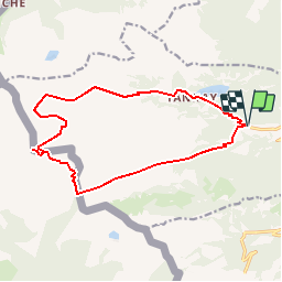
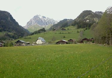
Tocht Andere activiteiten van 15,2 km beschikbaar op Valais/Wallis, Monthey, Vouvry. Deze tocht wordt voorgesteld door Romrando.
Beschrijving
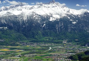
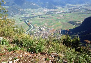
Itinéraire sans difficultés mais varié et contrasté.
En voiture par Vouvry gagner "Le Flon" au pied du lac Tanay et parquer la voiture au début de la route réservée au 4X4.
Suivre une petite route goudronnée vers l''W puis remonter toute la vallée le long d''une route à 4x4 jusqu''à l''alpage du "Coeur". De là gagner directement le col de Verne.
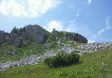
Remonter la bute vers le N pour gagner deux petits chalets (La Calaz) puis traverser à flanc vers la gauche pour remonter ensuite vers un petit col.
De là gagner le sommet en suivant le versant sud. (Attention toutefois par brouillard - nombreuses traces et falaises abruptes versant nord)
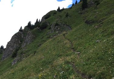
Redescendre au petit col puis prendre à gauche, direction WNW (attention aux fausses traces qui plongent directement et dangereusement dans la pente !) et suivre horizontalement une petite sente qui traverse des pentes très raide (dangereux en cas de névé tardif) pour rejoindre une grande combe.
De là un sentier balisé vers le NNE vous amène par quelques ressauts vers l''alpage de l''Au puis par une route caillouteuse rejoindre vers l''E le lac Tanay.
On rejoint alors le point de départ par la route.
Logement possible au lac Tanay http://www.isatis.ch/lactaney.html
Plaatsbepaling
Opmerkingen
Wandeltochten in de omgeving
![Tocht Stappen La Chapelle-d'Abondance - Le Linleu 2093 m, depuis Sevan-devant - Photo](https://media.geolcdn.com/t/375/260/ext.jpg?maxdim=2&url=https%3A%2F%2Fservices.sitytrail.com%2FGeolivesWS%2FDownloadMedia.ashx%3FTrailID%3D215118%26Media%3D15702_1.jpg)
![Stappen Stappen](https://static1.geolcdn.com/sitytour/trail-icons/101.png)
Stappen
![](/images/other/stat-length.png)
![](https://static1.geolcdn.com/siteimages/upload/files/16400158638029165_repeat_loop_refresh_sync_direction_icon.png)
![Tocht Te voet Vouvry - Miex-Lac Tanay (via Prélagine) - Photo](https://media.geolcdn.com/t/375/260/c59c9fa1-00dd-4194-9bdd-60bf51ceb886.jpeg&format=jpg&maxdim=2)
![Te voet Te voet](https://static1.geolcdn.com/sitytour/trail-icons/100.png)
Te voet
![](/images/other/stat-length.png)
![](https://static1.geolcdn.com/siteimages/upload/files/16400158638029165_repeat_loop_refresh_sync_direction_icon.png)
![Tocht Te voet Vionnaz - Torgon village - Chalet de Blancsex - Photo](https://media.geolcdn.com/t/375/260/d3e7664f-c0e4-4060-bc02-bdc516796cd2.jpeg&format=jpg&maxdim=2)
![Te voet Te voet](https://static1.geolcdn.com/sitytour/trail-icons/100.png)
Te voet
![](/images/other/stat-length.png)
![](https://static1.geolcdn.com/siteimages/upload/files/16400158638029165_repeat_loop_refresh_sync_direction_icon.png)
![Tocht Te voet Vionnaz - Torgon village - Dravers - Photo](https://media.geolcdn.com/t/375/260/d3e7664f-c0e4-4060-bc02-bdc516796cd2.jpeg&format=jpg&maxdim=2)
![Te voet Te voet](https://static1.geolcdn.com/sitytour/trail-icons/100.png)
Te voet
![](/images/other/stat-length.png)
![](https://static1.geolcdn.com/siteimages/upload/files/16400158638029165_repeat_loop_refresh_sync_direction_icon.png)
![Tocht Stappen Vouvry - Lac Tanay - Photo](https://media.geolcdn.com/t/375/260/ext.jpg?maxdim=2&url=https%3A%2F%2Fservices.sitytrail.com%2FGeolivesWS%2FDownloadMedia.ashx%3FTrailID%3D473755%26Media%3D20150920155631.jpg)
![Stappen Stappen](https://static1.geolcdn.com/sitytour/trail-icons/101.png)
Stappen
![](/images/other/stat-length.png)
![](https://static1.geolcdn.com/siteimages/upload/files/16400158638029165_repeat_loop_refresh_sync_direction_icon.png)
![Tocht Andere activiteiten La Chapelle-d'Abondance - chapelle d abondance Trebentaz chapelle d abondance - Photo](https://media.geolcdn.com/t/375/260/ext.jpg?maxdim=2&url=https%3A%2F%2Fservices.sitytrail.com%2FGeolivesWS%2FDownloadMedia.ashx%3FTrailID%3D461655%26Media%3D20150820144951.jpg)
![Andere activiteiten Andere activiteiten](https://static1.geolcdn.com/sitytour/trail-icons/900.png)
Andere activiteiten
![](/images/other/stat-length.png)
![](https://static1.geolcdn.com/siteimages/upload/files/16400158638029165_repeat_loop_refresh_sync_direction_icon.png)
![Tocht Stappen La Chapelle-d'Abondance - Plainr de Joux - Photo](https://media.geolcdn.com/t/375/260/ext.jpg?maxdim=2&url=https%3A%2F%2Fservices.sitytrail.com%2FGeolivesWS%2FDownloadMedia.ashx%3FTrailID%3D303791%26Media%3Dfix__20140520164950.jpg)
![Stappen Stappen](https://static1.geolcdn.com/sitytour/trail-icons/101.png)
Stappen
![](/images/other/stat-length.png)
![](https://static1.geolcdn.com/siteimages/upload/files/16400158638029165_repeat_loop_refresh_sync_direction_icon.png)
![Tocht Andere activiteiten La Chapelle-d'Abondance - savalenaz - Photo](https://media.geolcdn.com/t/375/260/ext.jpg?maxdim=2&url=https%3A%2F%2Fservices.sitytrail.com%2FGeolivesWS%2FDownloadMedia.ashx%3FTrailID%3D144221%26Media%3D20120802142554.jpeg)
![Andere activiteiten Andere activiteiten](https://static1.geolcdn.com/sitytour/trail-icons/900.png)
Andere activiteiten
![](/images/other/stat-length.png)
![](https://static1.geolcdn.com/siteimages/upload/files/16400158638029165_repeat_loop_refresh_sync_direction_icon.png)
![Tocht Mountainbike Port-Valais - st gingolf - Photo](https://media.geolcdn.com/t/375/260/85720ac9-ad9a-4743-9daa-6024b8efa637.jpg&format=jpg&maxdim=2)
![Mountainbike Mountainbike](https://static1.geolcdn.com/sitytour/trail-icons/202.png)
Mountainbike
![](/images/other/stat-length.png)
![](https://static1.geolcdn.com/siteimages/upload/files/16400158638029165_repeat_loop_refresh_sync_direction_icon.png)