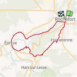
![](/images/other/stat-length.png)
![Tocht Stappen Rochefort - Natuur - De resurgentie van Eprave - Rochefort - Photo](https://media.geolcdn.com/t/1900/400/ext.pjpeg?maxdim=2&url=https%3A%2F%2Fservices.sitytrail.com%2FGeolivesWS%2FDownloadMedia.ashx%3FTrailID%3D183884%26Media%3D24990c63-64d5-49da-ab2b-14d425e0f53c.jpg)
Natuur - De resurgentie van Eprave - Rochefort
Maison du Tourisme Famenne - Ardenne Ourthe & Lesse
Randonnées de la Maison du Tourisme Famenne - Ardenne Ourthe & Lesse PRO
![Lengte](/images/other/stat-length.png)
![Max. hoogte](https://static1.geolcdn.com/siteimages/upload/files/1508320355ic_sort_altitude_max_24dp.png)
![Positief hoogteverschil](https://static1.geolcdn.com/siteimages/upload/files/1508320355ic_sort_den_pos_24dp.png)
![Km-Effort](/images/other/stat-length.png)
![Min. hoogte](https://static1.geolcdn.com/siteimages/upload/files/1508320355ic_sort_altitude_min_24dp.png)
![Negatief hoogteverschil](https://static1.geolcdn.com/siteimages/upload/files/1508320355ic_sort_den_neg_24dp.png)
![Boucle](https://static1.geolcdn.com/siteimages/upload/files/16400158638029165_repeat_loop_refresh_sync_direction_icon.png)
![Stappen](https://static1.geolcdn.com/sitytour/trail-icons/101.png)
3h46
Moeilijkheid : Moeilijk
![Scan deze QR-code om de tocht te openen in de SityTrail-applicatie](https://capi.geolives.com/qq0zvz2zws4bq2lad0pu/sitytour/trails/183884/qr.png?size=200)
Gratisgps-wandelapplicatie
Over ons
Tocht Stappen van 14,1 km beschikbaar op Wallonië, Namen, Rochefort. Deze tocht wordt voorgesteld door Maison du Tourisme Famenne - Ardenne Ourthe & Lesse.
Beschrijving
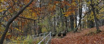
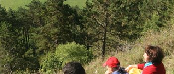
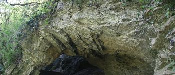
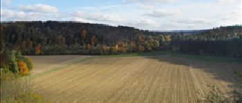
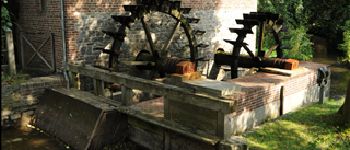
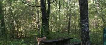
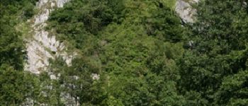
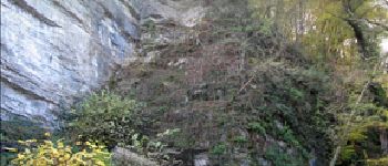
Mooie wandeling van ongeveer 14km op ontdekking van onze natuurpracht met beeldschone panorama’s zoals de Belvédère en de Resurgentie van Eprave, maar ook een brede scala aan erfgoedparels.
POI's
Plaatsbepaling
Opmerkingen
Wandeltochten in de omgeving
![Tocht Stappen Rochefort - Havrenne en de Sint-Remy Abdij - Roadbook Famenne-Ardennen - Photo](https://media.geolcdn.com/t/375/260/ext.jpg?maxdim=2&url=https%3A%2F%2Fservices.sitytrail.com%2FGeolivesWS%2FDownloadMedia.ashx%3FTrailID%3D215623%26Media%3Db529a95c-404d-4caa-9c09-6087624067bf.tif)
![Stappen Stappen](https://static1.geolcdn.com/sitytour/trail-icons/101.png)
Stappen
![](/images/other/stat-length.png)
![](https://static1.geolcdn.com/siteimages/upload/files/16400158638029165_repeat_loop_refresh_sync_direction_icon.png)
![Tocht Stappen Rochefort - Natuur - het panoramra van de Belvédère in Han-sur-Lesse - Photo](https://media.geolcdn.com/t/375/260/ext.jpg?maxdim=2&url=https%3A%2F%2Fservices.sitytrail.com%2FGeolivesWS%2FDownloadMedia.ashx%3FTrailID%3D193579%26Media%3D5797bc56-5327-4c2b-b581-d88d672bf775.jpg)
![Stappen Stappen](https://static1.geolcdn.com/sitytour/trail-icons/101.png)
Stappen
![](/images/other/stat-length.png)
![](https://static1.geolcdn.com/siteimages/upload/files/16400158638029165_repeat_loop_refresh_sync_direction_icon.png)
![Tocht Motor Rochefort - Autorit - Erfgoed : kerken, kapellen en abdijen - Rochefort - Photo](https://media.geolcdn.com/t/375/260/ext.jpg?maxdim=2&url=https%3A%2F%2Fservices.sitytrail.com%2FGeolivesWS%2FDownloadMedia.ashx%3FTrailID%3D153103%26Media%3D05603f1b-9f7c-481f-bc84-6cc819555dbb.jpg)
![Motor Motor](https://static1.geolcdn.com/sitytour/trail-icons/400.png)
Motor
![](/images/other/stat-length.png)
![](https://static1.geolcdn.com/siteimages/upload/files/16400158638029165_repeat_loop_refresh_sync_direction_icon.png)
![Tocht Stappen Rochefort - RB-Na-07 Raccourci - Ronde au pays des grottes - Photo](https://media.geolcdn.com/t/375/260/ext.jpg?maxdim=2&url=https%3A%2F%2Fservices.sitytrail.com%2FGeolivesWS%2FDownloadMedia.ashx%3FTrailID%3D213757%26Media%3D27dc9085-0323-4669-9df4-56be0512bfe6.jpg)
![Stappen Stappen](https://static1.geolcdn.com/sitytour/trail-icons/101.png)
Stappen
![](/images/other/stat-length.png)
![](https://static1.geolcdn.com/siteimages/upload/files/16400158638029165_repeat_loop_refresh_sync_direction_icon.png)
![Tocht Stappen Rochefort - Natuur - Ontdekkingswandeling in Han-sur-Lesse - Photo](https://media.geolcdn.com/t/375/260/ext.jpg?maxdim=2&url=https%3A%2F%2Fservices.sitytrail.com%2FGeolivesWS%2FDownloadMedia.ashx%3FTrailID%3D148989%26Media%3D3c202c2f-ee01-4903-bd25-24913ec8637b.jpg)
![Stappen Stappen](https://static1.geolcdn.com/sitytour/trail-icons/101.png)
Stappen
![](/images/other/stat-length.png)
![](https://static1.geolcdn.com/siteimages/upload/files/16400158638029165_repeat_loop_refresh_sync_direction_icon.png)
![Stappen Stappen](https://static1.geolcdn.com/sitytour/trail-icons/101.png)
Stappen
![](/images/other/stat-length.png)
![](https://static1.geolcdn.com/siteimages/upload/files/16400158638029165_repeat_loop_refresh_sync_direction_icon.png)
![Tocht Motor Rochefort - Roadbook met de wagen of motor - Circuit streekgebonden smaken - Photo](https://media.geolcdn.com/t/375/260/ext.jpg?maxdim=2&url=https%3A%2F%2Fservices.sitytrail.com%2FGeolivesWS%2FDownloadMedia.ashx%3FTrailID%3D428715%26Media%3Dff47641a-75c9-4285-926b-b7008d6e40b8.png)
![Motor Motor](https://static1.geolcdn.com/sitytour/trail-icons/400.png)
Motor
![](/images/other/stat-length.png)
![](https://static1.geolcdn.com/siteimages/upload/files/16400158638029165_repeat_loop_refresh_sync_direction_icon.png)
![Tocht Stappen Nassogne - Forrières/Lesterny - Promenade Saint-Martin (NG 08) - Photo](https://media.geolcdn.com/t/375/260/ext.jpg?maxdim=2&url=https%3A%2F%2Fservices.sitytrail.com%2FGeolivesWS%2FDownloadMedia.ashx%3FTrailID%3D334477%26Media%3Dba77daec-7d1b-4594-8484-87260d6142b8.jpg)
![Stappen Stappen](https://static1.geolcdn.com/sitytour/trail-icons/101.png)
Stappen
![](/images/other/stat-length.png)
![](https://static1.geolcdn.com/siteimages/upload/files/16400158638029165_repeat_loop_refresh_sync_direction_icon.png)
![Tocht Stappen Nassogne - Forrières - Promenade de Cocher (NG 07) - Photo](https://media.geolcdn.com/t/375/260/ext.jpg?maxdim=2&url=https%3A%2F%2Fservices.sitytrail.com%2FGeolivesWS%2FDownloadMedia.ashx%3FTrailID%3D334476%26Media%3D562f483c-8c06-4d7b-aecf-2f9a32b3894e.jpg)
![Stappen Stappen](https://static1.geolcdn.com/sitytour/trail-icons/101.png)
Stappen
![](/images/other/stat-length.png)
![](https://static1.geolcdn.com/siteimages/upload/files/16400158638029165_repeat_loop_refresh_sync_direction_icon.png)
balade faite de 12km de bitume sur 14. dommage
beetje saai
Informatief en zeer duidelijk
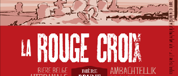
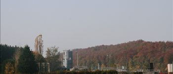
Balade sympa au début. Quelques beaux points de vue et sites intéressants. Mais les 6 derniers km sur la route, sans aménagement pour piétons donc long et dangereux, avec pour seul panorama un moulin, une station d'épuration (véridique) et la nationale tout le long, le tout sans prévenir et sans possibilité de raccourci...
ludique
Rochefort
4
roche
Première partie très sympa mais les 6 derniers km se font sur route et à découvert. Dur dur par très beau temps.