![](/images/other/stat-length.png)
![Tocht Andere activiteiten Andermatt - SCA-00-Sentier culturel des Alpes - Est - Photo](https://media.geolcdn.com/t/1900/400/ext.pjpeg?maxdim=2&url=https%3A%2F%2Fstatic1.geolcdn.com%2Fsiteimages%2Fupload%2Ffiles%2F1545311037marcheuse_200dpi.jpg)
SCA-00-Sentier culturel des Alpes - Est
Dgubler
Gebruiker
![Lengte](/images/other/stat-length.png)
Lengte
214 km
![Max. hoogte](https://static1.geolcdn.com/siteimages/upload/files/1508320355ic_sort_altitude_max_24dp.png)
Max. hoogte
2764 m
![Positief hoogteverschil](https://static1.geolcdn.com/siteimages/upload/files/1508320355ic_sort_den_pos_24dp.png)
Positief hoogteverschil
21709 m
![Km-Effort](/images/other/stat-length.png)
Km-Effort
504 km
![Min. hoogte](https://static1.geolcdn.com/siteimages/upload/files/1508320355ic_sort_altitude_min_24dp.png)
Min. hoogte
560 m
![Negatief hoogteverschil](https://static1.geolcdn.com/siteimages/upload/files/1508320355ic_sort_den_neg_24dp.png)
Negatief hoogteverschil
21969 m
![Boucle](https://static1.geolcdn.com/siteimages/upload/files/16400158638029165_repeat_loop_refresh_sync_direction_icon.png)
Boucle
Neen
Datum van aanmaak :
2014-12-11 00:00:00.0
Laatste wijziging :
2014-12-11 00:00:00.0
![Andere activiteiten](https://static1.geolcdn.com/sitytour/trail-icons/900.png)
--
Moeilijkheid : Onbekend
![Scan deze QR-code om de tocht te openen in de SityTrail-applicatie](https://capi.geolives.com/qq0zvz2zws4bq2lad0pu/sitytour/trails/18123/qr.png?size=200)
Gratisgps-wandelapplicatie
Over ons
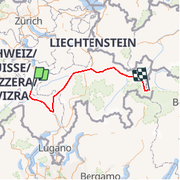
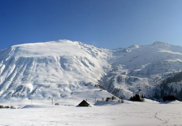
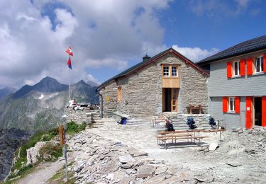
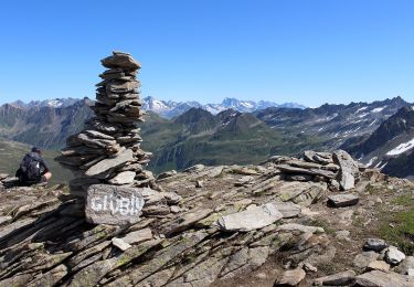
Tocht Andere activiteiten van 214 km beschikbaar op Uri, Korporation Ursern, Andermatt. Deze tocht wordt voorgesteld door Dgubler.
Beschrijving
Le Sentier culturel des Alpes (une initiative des Amis de la Nature, www.amisdelanature.ch), moitié orientale, d''Andermatt à Müstair.
The Eastern half of the Swiss Alps Cultural Trail, from Andermatt to Müstair.
Plaatsbepaling
Land:
Switzerland
Regio :
Uri
Departement/Provincie :
Korporation Ursern
Gemeente :
Andermatt
Locatie:
Unknown
Vertrek:(Dec)
Vertrek:(UTM)
469298 ; 5164430 (32T) N.
Opmerkingen
Wandeltochten in de omgeving
![Tocht Te voet Andermatt - Kräuterlehrpfad Mur - Photo](https://media.geolcdn.com/t/375/260/23ebdf3d-6550-42a3-bdcb-791aa1e419ea.jpeg&format=jpg&maxdim=2)
![Te voet Te voet](https://static1.geolcdn.com/sitytour/trail-icons/100.png)
Kräuterlehrpfad Mur
Te voet
Gemakkelijk
Andermatt,
Uri,
Korporation Ursern,
Switzerland
![](/images/other/stat-length.png)
7,6 km | 10,5 km-effort
2h 23min
![](https://static1.geolcdn.com/siteimages/upload/files/16400158638029165_repeat_loop_refresh_sync_direction_icon.png)
Neen
![Tocht Te voet Andermatt - Blumen- und Lawinenlehrpfad Chilchenberg - Photo](https://media.geolcdn.com/t/375/260/23ebdf3d-6550-42a3-bdcb-791aa1e419ea.jpeg&format=jpg&maxdim=2)
![Te voet Te voet](https://static1.geolcdn.com/sitytour/trail-icons/100.png)
Blumen- und Lawinenlehrpfad Chilchenberg
Te voet
Gemakkelijk
Andermatt,
Uri,
Korporation Ursern,
Switzerland
![](/images/other/stat-length.png)
3,9 km | 8,4 km-effort
1h 54min
![](https://static1.geolcdn.com/siteimages/upload/files/16400158638029165_repeat_loop_refresh_sync_direction_icon.png)
Neen
![Tocht Te voet Andermatt - Schöni - Pazolalücke - Photo](https://media.geolcdn.com/t/375/260/d1617093-8655-46c4-9467-a0f549651cea.jpeg&format=jpg&maxdim=2)
![Te voet Te voet](https://static1.geolcdn.com/sitytour/trail-icons/100.png)
Schöni - Pazolalücke
Te voet
Gemakkelijk
Andermatt,
Uri,
Korporation Ursern,
Switzerland
![](/images/other/stat-length.png)
3,7 km | 10,3 km-effort
2h 20min
![](https://static1.geolcdn.com/siteimages/upload/files/16400158638029165_repeat_loop_refresh_sync_direction_icon.png)
Neen
![Tocht Te voet Andermatt - Stöckli - Steglaui Riental - Photo](https://media.geolcdn.com/t/375/260/18a6a89b-b2db-4bc5-bdbd-b09a3baf89d4.jpeg&format=jpg&maxdim=2)
![Te voet Te voet](https://static1.geolcdn.com/sitytour/trail-icons/100.png)
Stöckli - Steglaui Riental
Te voet
Gemakkelijk
Andermatt,
Uri,
Korporation Ursern,
Switzerland
![](/images/other/stat-length.png)
6,7 km | 11,2 km-effort
2h 33min
![](https://static1.geolcdn.com/siteimages/upload/files/16400158638029165_repeat_loop_refresh_sync_direction_icon.png)
Neen
![Tocht Te voet Andermatt - Golfrundweg - Photo](https://media.geolcdn.com/t/375/260/89334e40-d25e-499c-90c6-7d30e1b20946.jpeg&format=jpg&maxdim=2)
![Te voet Te voet](https://static1.geolcdn.com/sitytour/trail-icons/100.png)
Golfrundweg
Te voet
Gemakkelijk
Andermatt,
Uri,
Korporation Ursern,
Switzerland
![](/images/other/stat-length.png)
5,6 km | 7,2 km-effort
1h 38min
![](https://static1.geolcdn.com/siteimages/upload/files/16400158638029165_repeat_loop_refresh_sync_direction_icon.png)
Ja
![Tocht Te voet Andermatt - Vermigel - Capanna Cadlimo - Photo](https://media.geolcdn.com/t/375/260/55e4726d-a963-4121-9825-2227d492a520.jpeg&format=jpg&maxdim=2)
![Te voet Te voet](https://static1.geolcdn.com/sitytour/trail-icons/100.png)
Vermigel - Capanna Cadlimo
Te voet
Gemakkelijk
Andermatt,
Uri,
Korporation Ursern,
Switzerland
![](/images/other/stat-length.png)
7,4 km | 17,6 km-effort
4h 0min
![](https://static1.geolcdn.com/siteimages/upload/files/16400158638029165_repeat_loop_refresh_sync_direction_icon.png)
Neen
![Tocht Te voet Andermatt - Lago della Sella - Sunnsbühl - Photo](https://media.geolcdn.com/t/375/260/8dfbce18-3c5b-4b83-9802-71ce5e04d009.jpeg&format=jpg&maxdim=2)
![Te voet Te voet](https://static1.geolcdn.com/sitytour/trail-icons/100.png)
Lago della Sella - Sunnsbühl
Te voet
Gemakkelijk
Andermatt,
Uri,
Korporation Ursern,
Switzerland
![](/images/other/stat-length.png)
5 km | 12,4 km-effort
2h 48min
![](https://static1.geolcdn.com/siteimages/upload/files/16400158638029165_repeat_loop_refresh_sync_direction_icon.png)
Neen
![Tocht Te voet Andermatt - Ursener Höhenweg - Photo](https://media.geolcdn.com/t/375/260/f7b36a6e-ed2a-4f4f-9e56-9c6f30267693.jpeg&format=jpg&maxdim=2)
![Te voet Te voet](https://static1.geolcdn.com/sitytour/trail-icons/100.png)
Ursener Höhenweg
Te voet
Medium
Andermatt,
Uri,
Korporation Ursern,
Switzerland
![](/images/other/stat-length.png)
13,9 km | 26 km-effort
5h 49min
![](https://static1.geolcdn.com/siteimages/upload/files/16400158638029165_repeat_loop_refresh_sync_direction_icon.png)
Neen
![Tocht Te voet Andermatt - Andermatt - Vermigel - Photo](https://media.geolcdn.com/t/375/260/ext.jpg?maxdim=2&url=https%3A%2F%2Fstatic1.geolcdn.com%2Fsiteimages%2Fupload%2Ffiles%2F1545311037marcheuse_200dpi.jpg)
![Te voet Te voet](https://static1.geolcdn.com/sitytour/trail-icons/100.png)
Andermatt - Vermigel
Te voet
Gemakkelijk
Andermatt,
Uri,
Korporation Ursern,
Switzerland
![](/images/other/stat-length.png)
5,5 km | 10,1 km-effort
2h 17min
![](https://static1.geolcdn.com/siteimages/upload/files/16400158638029165_repeat_loop_refresh_sync_direction_icon.png)
Neen