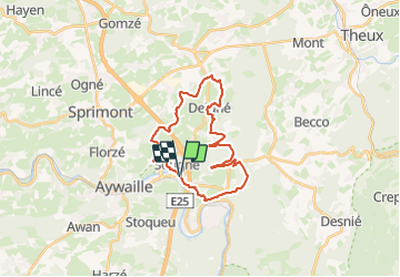
![](/images/other/stat-length.png)
![Tocht Stappen Aywaille - RB-Lg-12 - De Sougné-Remouchamps à Deigné et retour - Photo](https://media.geolcdn.com/t/1900/400/ext.pjpeg?maxdim=2&url=https%3A%2F%2Fservices.sitytrail.com%2FGeolivesWS%2FDownloadMedia.ashx%3FTrailID%3D179570%26Media%3D1074d230-2da3-49cf-8210-a5f6b46fd870.jpg)
RB-Lg-12 - De Sougné-Remouchamps à Deigné et retour
GR Rando
Randonnez sur et autour des GR ® wallons (Sentiers de Grande Randonnée). PRO
![Lengte](/images/other/stat-length.png)
![Max. hoogte](https://static1.geolcdn.com/siteimages/upload/files/1508320355ic_sort_altitude_max_24dp.png)
![Positief hoogteverschil](https://static1.geolcdn.com/siteimages/upload/files/1508320355ic_sort_den_pos_24dp.png)
![Km-Effort](/images/other/stat-length.png)
![Min. hoogte](https://static1.geolcdn.com/siteimages/upload/files/1508320355ic_sort_altitude_min_24dp.png)
![Negatief hoogteverschil](https://static1.geolcdn.com/siteimages/upload/files/1508320355ic_sort_den_neg_24dp.png)
![Boucle](https://static1.geolcdn.com/siteimages/upload/files/16400158638029165_repeat_loop_refresh_sync_direction_icon.png)
![Stappen](https://static1.geolcdn.com/sitytour/trail-icons/101.png)
7h39
Moeilijkheid : Moeilijk
![Scan deze QR-code om de tocht te openen in de SityTrail-applicatie](https://capi.geolives.com/qq0zvz2zws4bq2lad0pu/sitytour/trails/179570/qr.png?size=200)
Gratisgps-wandelapplicatie
Over ons
Tocht Stappen van 24 km beschikbaar op Wallonië, Luik, Aywaille. Deze tocht wordt voorgesteld door GR Rando.
Beschrijving
Remouchamps – La Porallée – ruisseau de Gervôvâ – Petite Mainire – Deigné – Adzeux – Hot’champs – Plâye – Sécheval – Remouchamps
Cartographie et documentation
Carte IGN au 1 : 20 000, 49/3-4 « Aywaille – Spa ».
Carte IGN des promenades pédestres, VTT et équestres, au 1 : 25 000 : « Aywaille,
Sougné-Remouchamps, Harzé, Deigné ».
Peuvent aussi apporter des renseignements utiles sur la région traversée, les topoguides
:
GR 571 « Vallées de Légendes ( Amblève – Salm – Lienne) » et GR 576 « Tour du
Condroz Liégeois (Huy – Hamoir – Remouchamps – Esneux – Huy) ».
Où se désaltérer et se restaurer :
Un restaurant à Deigné. Restaurants et cafés en grand nombre à Remouchamps et
à Aywaille.
Plaatsbepaling
Opmerkingen
Wandeltochten in de omgeving
![Tocht Stappen Aywaille - aywaille . florzé . martinrive . septroux . aywaille - Photo](https://media.geolcdn.com/t/375/260/8275975a-b8e8-47c1-9fb9-0580e1d080c9.jpg&format=jpg&maxdim=2)
![Stappen Stappen](https://static1.geolcdn.com/sitytour/trail-icons/101.png)
Stappen
![](/images/other/stat-length.png)
![](https://static1.geolcdn.com/siteimages/upload/files/16400158638029165_repeat_loop_refresh_sync_direction_icon.png)
![Tocht Stappen Aywaille - Petite remontée du Ninglispo - Photo](https://media.geolcdn.com/t/375/260/ext.jpg?maxdim=2&url=https%3A%2F%2Fservices.sitytrail.com%2FGeolivesWS%2FDownloadMedia.ashx%3FTrailID%3D536482%26Media%3D20160311161707.jpg)
![Stappen Stappen](https://static1.geolcdn.com/sitytour/trail-icons/101.png)
Stappen
![](/images/other/stat-length.png)
![](https://static1.geolcdn.com/siteimages/upload/files/16400158638029165_repeat_loop_refresh_sync_direction_icon.png)
![Tocht Stappen Aywaille - RB-LG-12 - Raccourci 2 - Photo](https://media.geolcdn.com/t/375/260/ext.jpg?maxdim=2&url=https%3A%2F%2Fservices.sitytrail.com%2FGeolivesWS%2FDownloadMedia.ashx%3FTrailID%3D209433%26Media%3D1f1ef83d-c0c7-4521-b15a-02c5e9e7c1f1.jpg)
![Stappen Stappen](https://static1.geolcdn.com/sitytour/trail-icons/101.png)
Stappen
![](/images/other/stat-length.png)
![](https://static1.geolcdn.com/siteimages/upload/files/16400158638029165_repeat_loop_refresh_sync_direction_icon.png)
![Tocht Stappen Aywaille - RB-Lg-15 - À la porte de l’Ardenne - Photo](https://media.geolcdn.com/t/375/260/ext.jpg?maxdim=2&url=https%3A%2F%2Fservices.sitytrail.com%2FGeolivesWS%2FDownloadMedia.ashx%3FTrailID%3D179573%26Media%3D790acd11-a9eb-4644-bdd3-c1540608bba1.jpg)
![Stappen Stappen](https://static1.geolcdn.com/sitytour/trail-icons/101.png)
Stappen
![](/images/other/stat-length.png)
![](https://static1.geolcdn.com/siteimages/upload/files/16400158638029165_repeat_loop_refresh_sync_direction_icon.png)
![Tocht Stappen Aywaille - 2021-04-23_12h03m48_1081 - Photo](https://media.geolcdn.com/t/375/260/fc604b5e-e950-4941-952b-ecd138cbf420.jpg&format=jpg&maxdim=2)
![Stappen Stappen](https://static1.geolcdn.com/sitytour/trail-icons/101.png)
Stappen
![](/images/other/stat-length.png)
![](https://static1.geolcdn.com/siteimages/upload/files/16400158638029165_repeat_loop_refresh_sync_direction_icon.png)
![Tocht Stappen Aywaille - 2021-02-21_16h28m36_1382 - Photo](https://media.geolcdn.com/t/375/260/73151627-72a6-4506-ac77-59fc8213a179.jpg&format=jpg&maxdim=2)
![Stappen Stappen](https://static1.geolcdn.com/sitytour/trail-icons/101.png)
Stappen
![](/images/other/stat-length.png)
![](https://static1.geolcdn.com/siteimages/upload/files/16400158638029165_repeat_loop_refresh_sync_direction_icon.png)
![Tocht Stappen Aywaille - aywaille . martinrive . awan . croix septroux . aywaille - Photo](https://media.geolcdn.com/t/375/260/ext.jpg?maxdim=2&url=https%3A%2F%2Fservices.sitytrail.com%2FGeolivesWS%2FDownloadMedia.ashx%3FTrailID%3D975360%26Media%3Dfix__20180528111338.jpg)
![Stappen Stappen](https://static1.geolcdn.com/sitytour/trail-icons/101.png)
Stappen
![](/images/other/stat-length.png)
![](https://static1.geolcdn.com/siteimages/upload/files/16400158638029165_repeat_loop_refresh_sync_direction_icon.png)
![Tocht Stappen Aywaille - RB-Lg-12 - Raccourci 1 - Photo](https://media.geolcdn.com/t/375/260/ext.jpg?maxdim=2&url=https%3A%2F%2Fservices.sitytrail.com%2FGeolivesWS%2FDownloadMedia.ashx%3FTrailID%3D209432%26Media%3D1074d230-2da3-49cf-8210-a5f6b46fd870.jpg)
![Stappen Stappen](https://static1.geolcdn.com/sitytour/trail-icons/101.png)
Stappen
![](/images/other/stat-length.png)
![](https://static1.geolcdn.com/siteimages/upload/files/16400158638029165_repeat_loop_refresh_sync_direction_icon.png)
![Tocht Stappen Aywaille - autour de Dieupart et Sougné sur les deux versants - Photo](https://media.geolcdn.com/t/375/260/6d29ace5-68d4-4c82-acad-a3ea752ffd24.jpg&format=jpg&maxdim=2)
![Stappen Stappen](https://static1.geolcdn.com/sitytour/trail-icons/101.png)
Stappen
![](/images/other/stat-length.png)
![](https://static1.geolcdn.com/siteimages/upload/files/16400158638029165_repeat_loop_refresh_sync_direction_icon.png)
Heel mooie wandeling. Bedankt!
belle rando