![](/images/other/stat-length.png)
![Tocht Stappen Bozouls - Trou de Bozouls - Photo](https://media.geolcdn.com/t/1900/400/ext.pjpeg?maxdim=2&url=https%3A%2F%2Fstatic1.geolcdn.com%2Fsiteimages%2Fupload%2Ffiles%2F1553511878bg_sport_marche.png)
Trou de Bozouls
jmpu
Gebruiker
![Lengte](/images/other/stat-length.png)
![Max. hoogte](https://static1.geolcdn.com/siteimages/upload/files/1508320355ic_sort_altitude_max_24dp.png)
![Positief hoogteverschil](https://static1.geolcdn.com/siteimages/upload/files/1508320355ic_sort_den_pos_24dp.png)
![Km-Effort](/images/other/stat-length.png)
![Min. hoogte](https://static1.geolcdn.com/siteimages/upload/files/1508320355ic_sort_altitude_min_24dp.png)
![Negatief hoogteverschil](https://static1.geolcdn.com/siteimages/upload/files/1508320355ic_sort_den_neg_24dp.png)
![Boucle](https://static1.geolcdn.com/siteimages/upload/files/16400158638029165_repeat_loop_refresh_sync_direction_icon.png)
![Stappen](https://static1.geolcdn.com/sitytour/trail-icons/101.png)
4h15
Moeilijkheid : Gemakkelijk
![Scan deze QR-code om de tocht te openen in de SityTrail-applicatie](https://capi.geolives.com/qq0zvz2zws4bq2lad0pu/sitytour/trails/178750/qr.png?size=200)
Gratisgps-wandelapplicatie
Over ons
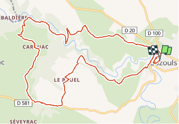
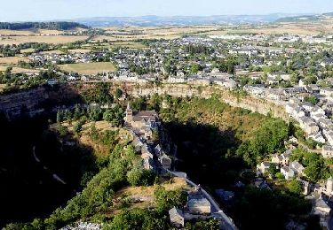
Tocht Stappen van 14,5 km beschikbaar op Occitanië, Aveyron, Bozouls. Deze tocht wordt voorgesteld door jmpu.
Beschrijving
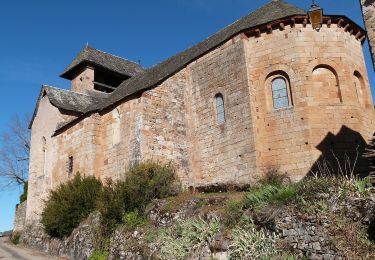
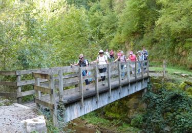
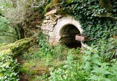
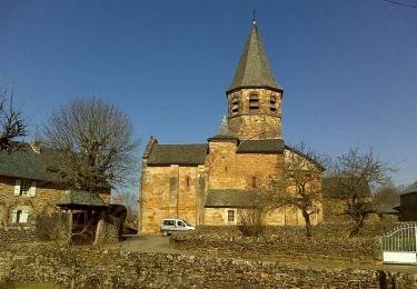
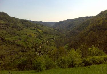
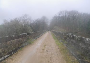
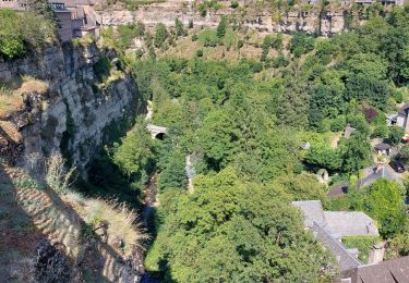
Départ du village BOZOULS (devant l'office de tourisme) descendre sur la gauche jusqu'au fond du "Trou". remonter de l'autre côté en passant devant l'église Ste Fauste. Continuer par le village Le BRUEL, ensuite CARCUAC. Virer à droite, rejoindre dans la Vallée, le pont enjambant la rivière Le Dourdou, remonter l'autre versant pour rejoindre SENTELS et continuer jusqu'à BOZOULS, en admirant sur la droite son superbe site "Le trou de Bozouls".
Plaatsbepaling
Opmerkingen
Wandeltochten in de omgeving
![Tocht Te voet Bozouls - De Bozouls à Rodelle - Photo](https://media.geolcdn.com/t/375/260/66d69220-9bbc-4663-b00f-c4b699fabe9e.jpeg&format=jpg&maxdim=2)
![Te voet Te voet](https://static1.geolcdn.com/sitytour/trail-icons/100.png)
Te voet
![](/images/other/stat-length.png)
![](https://static1.geolcdn.com/siteimages/upload/files/16400158638029165_repeat_loop_refresh_sync_direction_icon.png)
![Stappen Stappen](https://static1.geolcdn.com/sitytour/trail-icons/101.png)
Stappen
![](/images/other/stat-length.png)
![](https://static1.geolcdn.com/siteimages/upload/files/16400158638029165_repeat_loop_refresh_sync_direction_icon.png)
![Tocht Te voet Bozouls - BARRIAC / CARCUAC - Photo](https://media.geolcdn.com/t/375/260/bc0beb3d-ff65-476a-9036-ac117c703050.jpg&format=jpg&maxdim=2)
![Te voet Te voet](https://static1.geolcdn.com/sitytour/trail-icons/100.png)
Te voet
![](/images/other/stat-length.png)
![](https://static1.geolcdn.com/siteimages/upload/files/16400158638029165_repeat_loop_refresh_sync_direction_icon.png)
![Tocht Stappen Bozouls - Horizons et Clochers du Rouergue - Gillorgues - Photo](https://media.geolcdn.com/t/375/260/ext.jpg?maxdim=2&url=https%3A%2F%2Fservices.sitytrail.com%2FGeolivesWS%2FDownloadMedia.ashx%3FTrailID%3D118794%26Media%3D13001_3.jpg)
![Stappen Stappen](https://static1.geolcdn.com/sitytour/trail-icons/101.png)
Stappen
![](/images/other/stat-length.png)
![](https://static1.geolcdn.com/siteimages/upload/files/16400158638029165_repeat_loop_refresh_sync_direction_icon.png)
![Tocht Stappen Bozouls - De Barriac à Rodelle - Photo](https://media.geolcdn.com/t/375/260/ext.jpg?maxdim=2&url=https%3A%2F%2Fservices.sitytrail.com%2FGeolivesWS%2FDownloadMedia.ashx%3FTrailID%3D106448%26Media%3D10959_6.jpg)
![Stappen Stappen](https://static1.geolcdn.com/sitytour/trail-icons/101.png)
Stappen
![](/images/other/stat-length.png)
![](https://static1.geolcdn.com/siteimages/upload/files/16400158638029165_repeat_loop_refresh_sync_direction_icon.png)
![Tocht Mountainbike Bozouls - Roquelaure au départ de Bozouls - Photo](https://media.geolcdn.com/t/375/260/ext.jpg?maxdim=2&url=https%3A%2F%2Fservices.sitytrail.com%2FGeolivesWS%2FDownloadMedia.ashx%3FTrailID%3D106345%26Media%3D10807_4.jpg)
![Mountainbike Mountainbike](https://static1.geolcdn.com/sitytour/trail-icons/202.png)
Mountainbike
![](/images/other/stat-length.png)
![](https://static1.geolcdn.com/siteimages/upload/files/16400158638029165_repeat_loop_refresh_sync_direction_icon.png)
![Tocht Stappen Bozouls - Bozouls - Photo](https://media.geolcdn.com/t/375/260/10ed50db-8a0d-4207-a992-84c05341f3f1.jpg&format=jpg&maxdim=2)
![Stappen Stappen](https://static1.geolcdn.com/sitytour/trail-icons/101.png)
![Tocht Stappen Bozouls - Le tour du trou de Bizoul - Photo](https://media.geolcdn.com/t/375/260/4e72b031-faa1-4a85-a141-a5a945a90b8d.jpg&format=jpg&maxdim=2)
![Stappen Stappen](https://static1.geolcdn.com/sitytour/trail-icons/101.png)
Stappen
![](/images/other/stat-length.png)
![](https://static1.geolcdn.com/siteimages/upload/files/16400158638029165_repeat_loop_refresh_sync_direction_icon.png)
![Tocht Stappen Bozouls - Le site géologique de Bozouls - Photo](https://media.geolcdn.com/t/375/260/233a96fc-16b9-4e34-989d-cf9dd41d925a.jpg&format=jpg&maxdim=2)
![Stappen Stappen](https://static1.geolcdn.com/sitytour/trail-icons/101.png)
Stappen
![](/images/other/stat-length.png)
![](https://static1.geolcdn.com/siteimages/upload/files/16400158638029165_repeat_loop_refresh_sync_direction_icon.png)
sympa, surtout le début, après c'est un peu plat.
Très bonne app je l utilise à chaque village que je visite pour voir les ballades. Merci