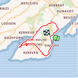
![](/images/other/stat-length.png)
![Tocht Stappen Plougastel-Daoulas - Boucle Tinduff - Four à Chaux - Photo](https://media.geolcdn.com/t/1900/400/ext.pjpeg?maxdim=2&url=https%3A%2F%2Fstatic1.geolcdn.com%2Fsiteimages%2Fupload%2Ffiles%2F1553511878bg_sport_marche.png)
Boucle Tinduff - Four à Chaux
Balades en Finistère
Promenez-vous au bout du monde !
![Lengte](/images/other/stat-length.png)
![Max. hoogte](https://static1.geolcdn.com/siteimages/upload/files/1508320355ic_sort_altitude_max_24dp.png)
![Positief hoogteverschil](https://static1.geolcdn.com/siteimages/upload/files/1508320355ic_sort_den_pos_24dp.png)
![Km-Effort](/images/other/stat-length.png)
![Min. hoogte](https://static1.geolcdn.com/siteimages/upload/files/1508320355ic_sort_altitude_min_24dp.png)
![Negatief hoogteverschil](https://static1.geolcdn.com/siteimages/upload/files/1508320355ic_sort_den_neg_24dp.png)
![Boucle](https://static1.geolcdn.com/siteimages/upload/files/16400158638029165_repeat_loop_refresh_sync_direction_icon.png)
![Stappen](https://static1.geolcdn.com/sitytour/trail-icons/101.png)
2h57
Moeilijkheid : Onbekend
![Scan deze QR-code om de tocht te openen in de SityTrail-applicatie](https://capi.geolives.com/qq0zvz2zws4bq2lad0pu/sitytour/trails/174873/qr.png?size=200)
Gratisgps-wandelapplicatie
Over ons
Tocht Stappen van 12,2 km beschikbaar op Bretagne, Finistère, Plougastel-Daoulas. Deze tocht wordt voorgesteld door Balades en Finistère.
Beschrijving
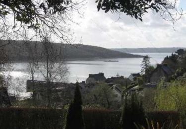
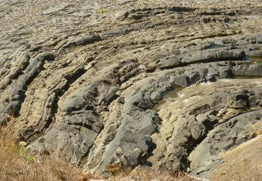
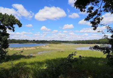
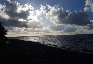
Au départ du petit port du Tinduff en passant par le four à Chaux au font de l'anse de l'Auberlac'h, vous profiterez des magnifiques paysages de la partie sud de la presqu'ile de Plougastel et de la rade de Brest
Plaatsbepaling
Opmerkingen
Wandeltochten in de omgeving
![Tocht Stappen Plougastel-Daoulas - Du Port de Lauberlac'h au Port du Caro - Photo](https://media.geolcdn.com/t/375/260/ext.jpg?maxdim=2&url=https%3A%2F%2Fservices.sitytrail.com%2FGeolivesWS%2FDownloadMedia.ashx%3FTrailID%3D109169%26Media%3D3212_1.jpg)
![Stappen Stappen](https://static1.geolcdn.com/sitytour/trail-icons/101.png)
Stappen
![](/images/other/stat-length.png)
![](https://static1.geolcdn.com/siteimages/upload/files/16400158638029165_repeat_loop_refresh_sync_direction_icon.png)
![Tocht Stappen Loperhet - LOPERHET - Photo](https://media.geolcdn.com/t/375/260/ec144ad2-2340-45b2-bcaa-5bedd5f31e25.jpg&format=jpg&maxdim=2)
![Stappen Stappen](https://static1.geolcdn.com/sitytour/trail-icons/101.png)
![Tocht Stappen Plougastel-Daoulas - circuit des chapelles à Plougastel - Photo](https://media.geolcdn.com/t/375/260/0f9e3fda-215f-431d-99b3-c9760e4eab78.jpg&format=jpg&maxdim=2)
![Stappen Stappen](https://static1.geolcdn.com/sitytour/trail-icons/101.png)
Stappen
![](/images/other/stat-length.png)
![](https://static1.geolcdn.com/siteimages/upload/files/16400158638029165_repeat_loop_refresh_sync_direction_icon.png)
![Tocht Stappen Plougastel-Daoulas - LOPERHET - Photo](https://media.geolcdn.com/t/375/260/d8291e88-a4dd-4120-98c4-dfa35d2cb0a1.jpg&format=jpg&maxdim=2)
![Stappen Stappen](https://static1.geolcdn.com/sitytour/trail-icons/101.png)
Stappen
![](/images/other/stat-length.png)
![](https://static1.geolcdn.com/siteimages/upload/files/16400158638029165_repeat_loop_refresh_sync_direction_icon.png)
![Tocht Te voet Logonna-Daoulas - Sentier Côtier - Photo](https://media.geolcdn.com/t/375/260/5cd226de-ab15-485c-ad56-76bdfb355d74.jpeg&format=jpg&maxdim=2)
![Te voet Te voet](https://static1.geolcdn.com/sitytour/trail-icons/100.png)
Te voet
![](/images/other/stat-length.png)
![](https://static1.geolcdn.com/siteimages/upload/files/16400158638029165_repeat_loop_refresh_sync_direction_icon.png)
![Tocht Stappen Logonna-Daoulas - Circuit de l'anse de Pen Foul. Logona. 06/07/20 - Photo](https://media.geolcdn.com/t/375/260/1dda4c52-fb47-4e06-aa03-a8ba7d97f79b.jpg&format=jpg&maxdim=2)
![Stappen Stappen](https://static1.geolcdn.com/sitytour/trail-icons/101.png)
Stappen
![](/images/other/stat-length.png)
![](https://static1.geolcdn.com/siteimages/upload/files/16400158638029165_repeat_loop_refresh_sync_direction_icon.png)
![Tocht Te voet Plougastel-Daoulas - Presqu’île de plougastel - Photo](https://media.geolcdn.com/t/375/260/ext.jpg?maxdim=2&url=https%3A%2F%2Fstatic1.geolcdn.com%2Fsiteimages%2Fupload%2Ffiles%2F1545311037marcheuse_200dpi.jpg)
![Te voet Te voet](https://static1.geolcdn.com/sitytour/trail-icons/100.png)
Te voet
![](/images/other/stat-length.png)
![](https://static1.geolcdn.com/siteimages/upload/files/16400158638029165_repeat_loop_refresh_sync_direction_icon.png)
![Tocht Stappen Logonna-Daoulas - porsisquin - bendy - Photo](https://media.geolcdn.com/t/375/260/9455fabc-a700-4621-a2e8-9ca572efd395.jpg&format=jpg&maxdim=2)
![Stappen Stappen](https://static1.geolcdn.com/sitytour/trail-icons/101.png)
Stappen
![](/images/other/stat-length.png)
![](https://static1.geolcdn.com/siteimages/upload/files/16400158638029165_repeat_loop_refresh_sync_direction_icon.png)
![Tocht Stappen Plougastel-Daoulas - PR Tour Kernisi - Le Caro - Saint Christine - Photo](https://media.geolcdn.com/t/375/260/ext.jpg?maxdim=2&url=https%3A%2F%2Fservices.sitytrail.com%2FGeolivesWS%2FDownloadMedia.ashx%3FTrailID%3D956411%26Media%3Dfix__20180430193220.jpg)
![Stappen Stappen](https://static1.geolcdn.com/sitytour/trail-icons/101.png)
Stappen
![](/images/other/stat-length.png)
![](https://static1.geolcdn.com/siteimages/upload/files/16400158638029165_repeat_loop_refresh_sync_direction_icon.png)
Très chouette